
Honghe Hani Titian and the stepped slopes of Yuanyang
Published on 09/19/2026 at 22:48 | Editorial responsibility: Rafael Müller, Editor-in-Chief AD HOC NEWS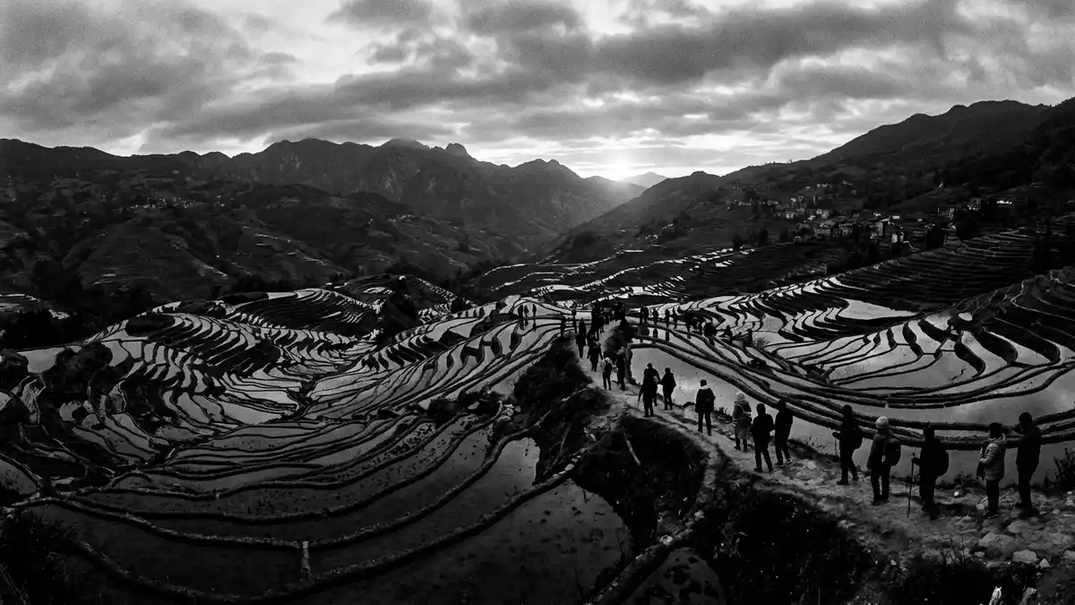
Honghe Hani Titian in Yuanyang is part of the Cultural Landscape of Honghe Hani Rice Terraces, a band of stepped fields cut into the southern slopes of the Ailao Mountains in Yunnan, China. The terraces form a World Heritage cultural site inscribed by UNESCO in 2013, where hillside rice fields, forest and Hani villages occupy different levels of the same mountain landscape.
Terraces, mountains and river: a layered landscape
The core of Honghe Hani Titian stretches across terrain in southern Yunnan where terraces descend from forested ridges towards the Hong River in long sweeps of earth and water. The UNESCO property covers 16,603 hectares in this region, defining a cultural landscape where rice paddies appear as thin bands that follow the contours of the Ailao slopes.16,603 hectares in Southern Yunnan On the hillsides around Yuanyang the terraces sit below belts of woodland, so that the upper slopes carry forest and the lower slopes carry fields.
Standing above Honghe Hani Titian, the stepped pattern of the terraces can be traced down to the banks of the Hong River, where the mountain flank meets the valley floor.terraces that cascade down the slopes The south-facing slopes of the Ailao Mountains in Yuanyang create a broad amphitheatre of fields, and the terraces lie in bands so closely spaced that individual plots form part of a single hillside system rather than isolated paddies.south-facing slopes of the Ailao Mountains
Hani communities and a long-lived terrace system
Honghe Hani Titian is closely linked with the Hani people, an officially recognised ethnic group in China whose farming villages and terraces share the same mountainsides. Over more than a millennium, Hani communities have developed hillside fields where water is guided from higher ground to irrigate terraces built across steep slopes.developed over the past 1300 years Within Yuanyang County, rice paddies, woodland and settlements are arranged in vertical zones, with forests on the upper slopes, villages on intermediate shelves and terrace fields occupying the lower bands of the mountains.
The terrace landscape extends beyond Yuanyang into other counties of Honghe Hani and Yi Autonomous Prefecture, but Yuanyang holds one of the most concentrated areas of steep terraces. The overall Hani Rice Terraces system covers tens of thousands of hectares across counties including Honghe, Yuanyang, Lvchun and Jinping, forming a large agricultural region where hillside farming has been maintained for generations.spread in four counties Within the UNESCO property boundary, terrace fields, water channels and village clusters together make up the cultural landscape recognised on the World Heritage List.Cultural Landscape of Honghe Hani Rice Terraces
Honghe Hani Titian within Yuanyang and Yunnan
Geographically, Honghe Hani Titian lies in Yuanyang County in Honghe Hani and Yi Autonomous Prefecture, in the south of Yunnan Province in China.Yuanyang County in Honghe Hani and Yi Autonomous Prefecture The terrace fields occupy south-facing slopes of the Ailao Mountains above the Hong River, forming a band of cultivation that tracks the natural rise and fall of the terrain. Within Yuanyang, Honghe Hani Titian is associated with several scenic areas and village groups where terraces layer down towards valley streams.
Yunnan itself is a province in south-west China known for its varied mountains and river systems, and the Honghe Hani Rice Terraces sit within that wider landscape as a hillside farming region rather than a single compact field. The nominated World Heritage property and its buffer zone lie in Yuanyang County, where the terrace pattern is among the most developed and closely arranged parts of the Hani Rice Terraces system.nominated area and buffer zone in Yuanyang county From vantage points around Yuanyang town, bands of terraces can be seen stepping down towards the Hong River, with forest and settlement marking contrasting stripes on the mountain slopes.
Visiting Honghe Hani Titian: what travellers from Western Europe should know
- Honghe Hani Titian lies in Yuanyang County in Honghe Hani and Yi Autonomous Prefecture in the south of Yunnan, China. Access to the terrace areas is by road from other parts of the province, including routes that lead towards Yuanyang and the hillside town of Xinjie.
- The terrace landscape occupies steep slopes on the south side of the Ailao Mountains, and approaches to viewpoints and village areas can involve walking along paths on gradients and stairways between terrace levels.
- The wider Honghe Hani Rice Terraces region extends across mountainous countryside, and the terrace bands around Yuanyang are spread over different valleys and hillsides rather than concentrated in a single, flat site.
- The official language is Chinese and the currency is the renminbi (yuan).
- Entry requirements depend on your nationality; UK travellers can check the FCDO travel advice at gov.uk/foreign-travel-advice, Irish travellers the Department of Foreign Affairs at ireland.ie.
Searching for Honghe Hani Titian on social platforms
These links open searches for Honghe Hani Titian on each platform.
Frequently asked questions about Honghe Hani Titian
Where is Honghe Hani Titian located?
Honghe Hani Titian is in Yuanyang County in Honghe Hani and Yi Autonomous Prefecture, in the south of Yunnan Province in China, on the southern slopes of the Ailao Mountains above the Hong River.
What can visitors expect to see at Honghe Hani Titian?
Visitors encounter a hillside farming landscape where rice terraces step down mountain slopes in closely spaced bands, with villages and forest occupying other levels of the terrain.
What makes Honghe Hani Titian distinctive among terrace landscapes?
Honghe Hani Titian forms part of a World Heritage cultural landscape recognised by UNESCO, combining extensive terrace fields, a long-established Hani farming system and a clearly layered arrangement of forest, settlement and irrigated slopes.


