
Honghe Hani Titian and the terraced mountains of Yuanyang
Published on 08/22/2026 at 23:05 | Editorial responsibility: Rafael Müller, Editor-in-Chief AD HOC NEWS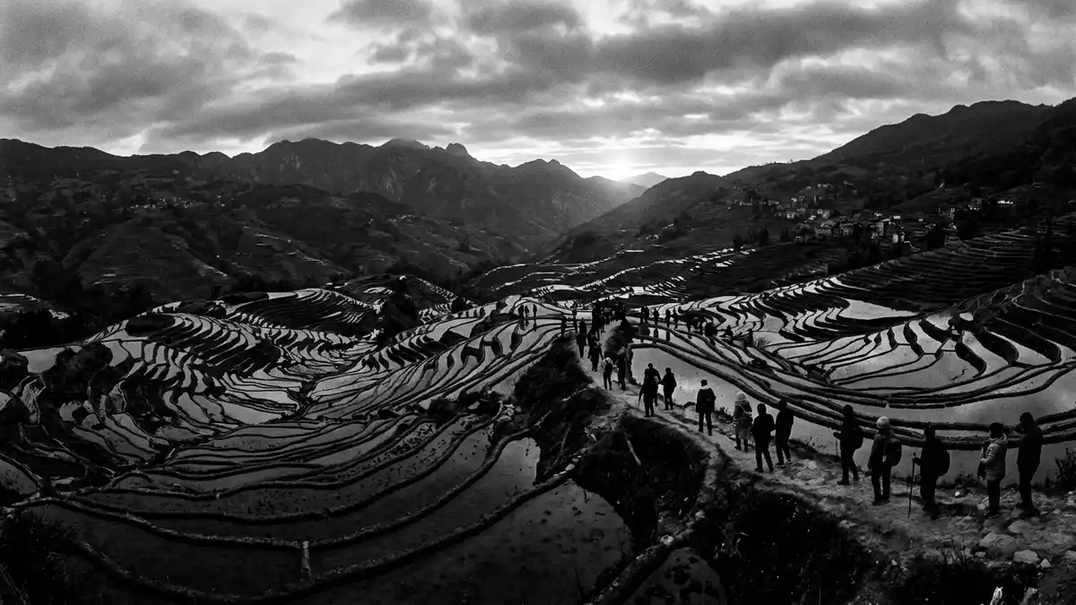
Honghe Hani Titian is the name given to the sweeping rice terraces carved into the slopes above the Hong River in Yuanyang, southern Yunnan, an immense cultural landscape created by Hani communities over many generations. The terraces form the core of the Honghe Hani Rice Terraces, a site recognised as a cultural landscape on the UNESCO World Heritage List in 2013, and stretch across mountainous terrain where villages, forests, fields and water channels sit closely together in a single, layered system.
Terraced mountains above the Hong River
The Honghe Hani Rice Terraces occupy the south-facing slopes of the Ailao Mountains, descending towards the Hong River in a dense pattern of stepped fields that follow the natural curves of the terrain.The terraces are located in Yuanyang County in Honghe Prefecture, in the south of Yunnan Province. Across the wider landscape they extend through several counties, but Yuanyang holds the area many travellers encounter first, with extensive terraced slopes surrounding villages such as Nansha, Xinjie and Niujiaozhai.
The UNESCO inscription defines a property of 16,603 hectares in southern Yunnan, where terraces cascade down the Ailao slopes to the banks of the Hong River in long, continuous sweeps of earth and water.The Cultural Landscape of Honghe Hani Rice Terraces is described as a State Priority Protected Site under Chinese law. Within that protected area, hillsides are systematically cut into agricultural levels that follow the contours of the mountainside, creating thousands of individual fields that together form the visual impression of Honghe Hani Titian.
A long history of water, earth and rice
The terraces in Yuanyang are traditionally dated to an origin around the thirteenth century, representing more than a thousand years of agricultural adaptation to a steep, humid mountain environment.Sources describe a history spanning roughly 1,200 years, in which Hani communities shaped the slopes into fields that could hold water for rice cultivation. Over generations, the terraces and their irrigation channels have been extended, repaired and reshaped, so that the landscape visitors see now is the result of cumulative work rather than a single period of construction.
Water management is fundamental to Honghe Hani Titian.Descriptions of the rice terraces emphasise a complex system of channels carrying water from forested hilltops down to the fields, using gravity to distribute flow across the slopes. At higher elevations, forest areas feed springs and streams; below them sit villages built on more stable ground; beneath the houses the terraces begin, and below the terraces the river system collects the water again. This vertical sequence of forest, village, terraces and river is one of the defining patterns of the Honghe Hani Rice Terraces landscape.
Villages, viewpoints and seasonal landscapes
Honghe Hani Titian is closely tied to the villages embedded among the terraces, where Hani and other ethnic communities live in houses constructed with locally available earth and brick, with roofs suited to a humid subtropical climate.Accounts of the cultural landscape highlight around eighty villages within the broader World Heritage area, many on ridges or spurs between terraced slopes. The daily movement between houses, fields and forest forms part of the landscape’s character, and from high vantage points visitors can see paths, minor tracks and small roads crossing the terraces.
Several named terrace areas have become established viewpoints in Yuanyang, each with its own configuration of fields and valley views. Bada, Laohuzui and Duoyishu are frequently cited as large terrace concentrations, with broad sweeps of fields and clusters of villages around them.Descriptions of Yuanyang speak of these three areas as the main zones for viewing terraces, set at different elevations and orientations. Across the year, the appearance of Honghe Hani Titian changes as fields are flooded, planted, grown and harvested, creating sequences of mirrored surfaces, green rice plants and later dry earth depending on the agricultural cycle.
Visiting Honghe Hani Titian: what travellers from Western Europe should know
- Honghe Hani Titian lies in Yuanyang County in southern Yunnan, in the Honghe Hani and Yi Autonomous Prefecture; access commonly begins from Kunming by road towards Yuanyang and the hillside town of Xinjie.
- The terraces occupy steep mountain slopes, and visiting viewpoints or village paths involves walking on gradients and stairways, with uneven earth surfaces and steps cut into the hillside.
- Yuanyang sits in a subtropical, highland climate zone, and the terraced landscape reflects marked seasonal changes in water levels and vegetation.
- The official language is Chinese and the currency is the renminbi (yuan).
- Entry requirements depend on your nationality; UK travellers can check the FCDO travel advice at gov.uk/foreign-travel-advice, Irish travellers the Department of Foreign Affairs at ireland.ie.
Searching for Honghe Hani Titian on social platforms
These links open searches for Honghe Hani Titian on each platform.
Frequently asked questions about Honghe Hani Titian
Where is Honghe Hani Titian?
Honghe Hani Titian refers to the rice terraces on the southern slopes of the Ailao Mountains in Yuanyang County, in the Honghe Hani and Yi Autonomous Prefecture of Yunnan, China.
What should travellers expect on a visit?
Travellers encounter terraced slopes descending towards the Hong River, with village areas among the fields and viewpoints looking across a wide agricultural landscape shaped over centuries.
What makes Honghe Hani Titian distinctive among rice terraces?
The landscape combines forest, villages, terraces and river in a continuous vertical sequence, with an extensive, long-established system of water channels feeding thousands of stepped fields on steep mountain slopes.


