
Trolltunga, the horizontal rock ledge above Ringedalsvatnet
Published on 09/18/2026 at 19:12 | Editorial responsibility: Rafael Müller, Editor-in-Chief AD HOC NEWS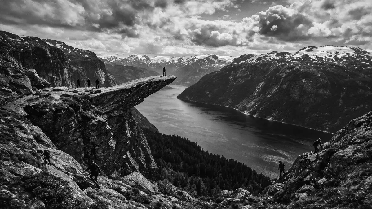
Trolltunga is a horizontal rock ledge of ancient bedrock in Ullensvang, rising high above Ringedalsvatnet in western Norway’s Hardanger region and forming a natural balcony over the lake and surrounding mountains.
A tongue of rock above a glacial lake
The name Trolltunga translates as “the troll’s tongue” in Norwegian and refers to the way the narrow slab of rock projects from the mountainside, resembling a tongue extending over the valley.The name TrolltungaThe ledge belongs to Ullensvang municipality in Vestland county, in the inland mountains behind the Hardangerfjord coastline of western Norway.Ullensvang municipality in Vestland
Trolltunga sits more than 1,100 m (around 3,600 ft) above sea level on a high plateau of bare rock and scattered pools, with its outer edge suspended several hundred metres above the long, narrow lake Ringedalsvatnet.over 1,100 m above sea levelThe cliff is part of a wider upland area shaped by glacial ice during the last Ice Age, where moving ice and meltwater carved wide valleys and left behind rounded summits and scoured rock surfaces across the Hardanger region.shaped by glacial ice
Ancient bedrock and Hardangervidda landscapes
The rock platform of Trolltunga forms part of the mountains above Ringedalsvatnet, where ancient bedrock is exposed in slabs and ridges with patches of vegetation in hollows and on gentler slopes.a horizontal cliff ledge of ancient bedrockThe wider plateau links towards Hardangervidda, the extensive upland area of southern Norway known for its rounded summits, glacier-shaped basins and broad, open high country crossed by lakes and streams.the wider Hardangervidda area
The rock tongue itself is a slab of hard stone protruding from the mountain wall above the north side of Ringedalsvatnet, ending in a flat surface where the bedrock tapers towards the valley.juts horizontally out from the mountainGlacial activity scraped away material from the surrounding cliff and left the projecting platform exposed, so the ledge now hangs freely over the water with sheer drops to the lake and steep rock walls framing the view along the valley.glaciers carved this rock platform
Approach routes and the high plateau hike
Trolltunga lies inland from the Hardangerfjord near the town of Odda and the village of Tyssedal, in the mountainous part of Ullensvang where roads and hydroelectric installations reach into steep valleys.near the town of Odda and TyssedalThe standard approach starts from Skjeggedal above Tyssedal, where a road climbs from the valley and a marked mountain path continues towards the plateau and the cliff ledge.starting point for the Trolltunga hike
From Skjeggedal the route gains height on steep sections near the line of the former Mågelibanen funicular and then crosses high ground of rock slabs, hollows and small lakes towards the cliff above Ringedalsvatnet.climbs steeply then crosses open plateausThe path is long and demanding on the legs, with repeated short ascents and descents across undulating ridges, and reaches the narrow tongue of rock as a final viewpoint before turning back across the same mountain landscape to the valley trailhead.round-trip hike from Skjeggedal
Visiting Trolltunga: what travellers from Western Europe should know
- Trolltunga is situated in Ullensvang municipality in Vestland, in the inland mountains behind the Hardangerfjord coastline of western Norway, with the main road access through Tyssedal near Odda.
- The standard hiking route begins in Skjeggedal above Tyssedal, climbing steeply near the old Mågelibanen line before continuing across a long high plateau of bare rock, small lakes and undulating ridges.
- The terrain on the plateau is rocky and uneven, with sections of stone slabs, boggy ground and short steep climbs, and the final approach to the cliff ledge runs close to sheer drops above Ringedalsvatnet.
- Trolltunga stands at more than 1,100 m (around 3,600 ft) above sea level and several hundred metres above the lake, so weather, visibility and temperature on the plateau can differ markedly from the fjord valley below.
- The official language is Norwegian and the currency is the Norwegian krone; entry requirements depend on your nationality, UK travellers can check the FCDO travel advice at gov.uk/foreign-travel-advice, Irish travellers the Department of Foreign Affairs at ireland.ie.
Searching for Trolltunga on social platforms
These links open searches for Trolltunga on each platform.Frequently asked questions about Trolltunga
Where is Trolltunga?
Trolltunga is in Ullensvang municipality in Vestland county in western Norway, in the inland mountains above Ringedalsvatnet near Odda and Tyssedal.
What should travellers expect on a visit to Trolltunga?
Travellers encounter a long mountain hike across rocky plateau terrain to reach a narrow slab of bedrock projecting high above a glacial lake, with steep drops near the viewpoint.
What makes Trolltunga distinctive among Norwegian mountain viewpoints?
Trolltunga is distinguished by its horizontal tongue of rock jutting from a sheer cliff wall hundreds of metres above Ringedalsvatnet, creating a flat natural ledge above open air.


