

Trolltunga, Norway’s horizontal cliff above Ringedalsvatnet
Published on 09/01/2026 at 17:00 | Editorial responsibility: Rafael Müller, Editor-in-Chief AD HOC NEWS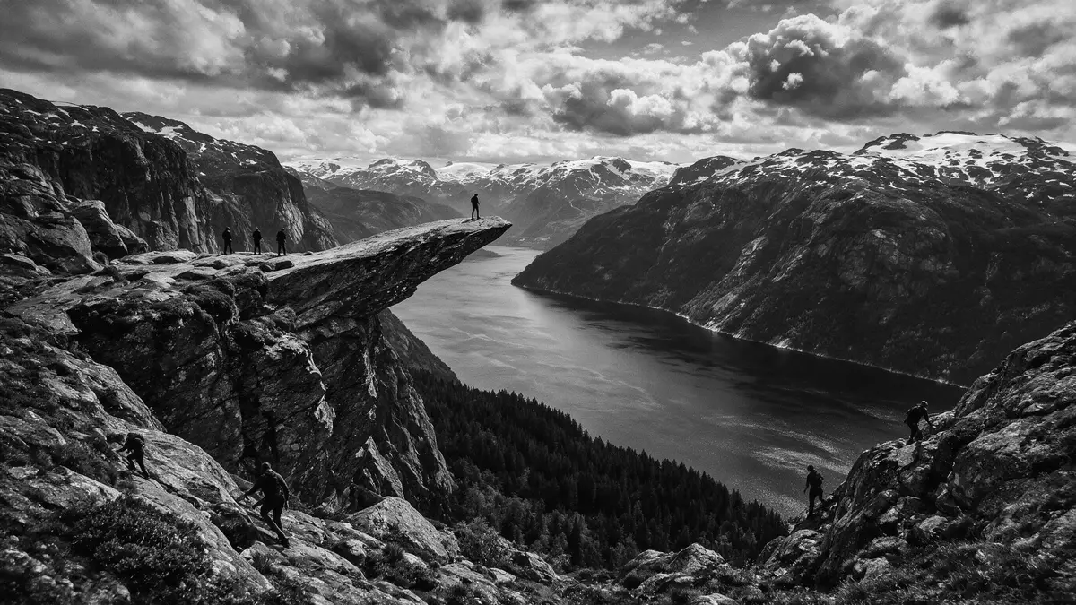
Trolltunga is a horizontal cliff ledge of ancient bedrock in Ullensvang, rising high above Ringedalsvatnet in western Norway’s Hardanger region and forming a striking natural balcony over the lake and surrounding mountains.
A cliff like a tongue above Ringedalsvatnet
Seen from the plateau, Trolltunga appears as a long, narrow slab projecting out from the mountain wall, with its outer edge hanging directly over the valley and the long waters of Ringedalsvatnet below. The rock formation sits in Ullensvang municipality in Vestland county, in the inland mountains behind the Hardangerfjord coastline of western Norway.Ullensvang municipality in Vestland The ledge lies at an elevation of over 1,100 m (around 3,600 ft) above sea level, suspended several hundred metres above the surface of Ringedalsvatnet, which stretches below as a long, narrow lake framed by steep slopes.over 1,100 m above sea level
The name translates as “Troll’s Tongue” in Norwegian and reflects the way the rock juts horizontally from the cliff face, resembling a tongue extending into the air above the valley. Around the ledge, the landscape shows clear traces of glacial carving, with rounded summits, scoured rock surfaces and a valley shaped by ice and meltwater that left Ringedalsvatnet as a long basin flooded with deep water.glacier-shaped valleys around Ringedalsvatnet The plateau forms part of the wider Hardanger area, where the fjord arms and inland mountains together create a landscape of cliffs, water and high ground.
Hardanger mountains and a lake far below
Trolltunga lies in the mountains above the Sørfjorden arm of the Hardangerfjord, inland from the fjord town of Odda and close to the smaller settlement of Tyssedal in Ullensvang.inland from the Sørfjorden arm of the Hardangerfjord From the valley floor, the terrain rises quickly into a high mountain plateau, where the bedrock forms broad surfaces cut by streams and scattered with small tarns and patches of vegetation adapted to the altitude and climate. The lake Ringedalsvatnet lies far below the cliff ledge, occupying a long, narrow valley that mirrors the direction of the surrounding ridges.
On the approach to the plateau, the path passes through sections of birch woodland and scrub before reaching more open, rocky ground, where views open up towards distant peaks and across the lake basin. The cliff itself forms part of a larger rock face that drops almost vertically towards Ringedalsvatnet, with the ledge extending outward from this wall. Around Trolltunga, visitors see a combination of smooth rock, patches of soil and low vegetation, together with pools and streams that collect meltwater from the higher slopes.rock surfaces and surrounding mountains The wider Hardanger region is known for its combination of fjords, lakes and mountain plateaus, and Trolltunga stands as one of its more dramatic cliff formations.
The long mountain hike from Skjeggedal
Trolltunga is reached on foot from the mountain valley of Skjeggedal above Tyssedal, where marked paths climb into the high terrain before levelling out on the plateau above Ringedalsvatnet.paths from Skjeggedal above Tyssedal From the main trailhead, the route gains significant height over the first part of the hike, then continues across undulating ground with sections of rock, earth and wooden walkways laid in wetter areas. Hikers traverse areas of exposed bedrock and cross streams and small valleys before reaching the final approach along the plateau towards the cliff ledge.
The full out-and-back hike from the valley is a demanding mountain walk, with considerable ascent and descent over a substantial distance and a trail that includes steep gradients, rocky sections and high-altitude terrain. Norway’s grading systems class the route as very demanding, suitable for walkers with solid mountain experience and fitness, and the path is treated as a significant hike rather than a short excursion.Norwegian Scenic Hike certification and demanding grading Along the way, waymarkers and signs guide walkers across the plateau, and there are viewpoints where the landscape opens towards the lake and the surrounding mountains.
Visiting Trolltunga: what travellers from Western Europe should know
- Trolltunga lies in Ullensvang municipality in western Norway, inland from the Sørfjorden arm of the Hardangerfjord and reached by road via the town of Odda and the nearby village of Tyssedal.
- The main hiking trail starts in the mountain valley of Skjeggedal above Tyssedal, climbing steeply at first and then continuing across high plateau terrain towards the cliff ledge above Ringedalsvatnet.
- The route covers a substantial distance over rocky ground and high-altitude terrain, with marked paths that include steep gradients, exposed sections and stream crossings, demanding solid mountain fitness and preparation.
- The official language is Norwegian and the currency is the Norwegian krone.
- Entry requirements depend on your nationality; UK travellers can check the FCDO travel advice at gov.uk/foreign-travel-advice, Irish travellers the Department of Foreign Affairs at ireland.ie.
Searching for Trolltunga on social platforms
These links open searches for Trolltunga on each platform.
Frequently asked questions about Trolltunga
Where is Trolltunga and what landscape surrounds it?
Trolltunga is in Ullensvang municipality in Vestland county in western Norway, in the inland mountains above Ringedalsvatnet and the Sørfjorden arm of the Hardangerfjord.
What should visitors expect on the hike to Trolltunga?
Visitors can expect a long, demanding mountain walk from Skjeggedal, with steep climbs, rocky paths and high plateau terrain before reaching the cliff ledge above the lake.
What makes Trolltunga distinctive among Norwegian cliff formations?
Trolltunga is distinctive for its narrow rock slab projecting horizontally from a high cliff wall, suspended far above a long glacial lake in the Hardanger mountains.


