
Otaru Unga, the curved canal of stone warehouses in Otaru
Published on 09/18/2026 at 15:13 | Editorial responsibility: Rafael Müller, Editor-in-Chief AD HOC NEWS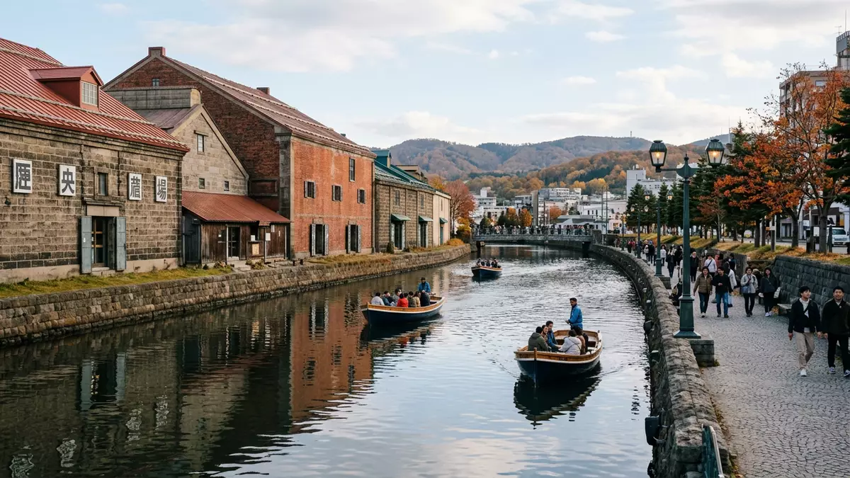
Otaru Unga, known in English as the Otaru Canal, is a gently curving harbour waterway in the port city of Otaru on the western side of Hokkaido in Japan. It was constructed in the early twentieth century and completed in 1923 as part of a wider harbour reclamation project that reshaped Otaru’s shoreline into a working waterfront of quays, barges and warehouses.Completed in 1923 the canal still traces the line of the historic quay, and walking beside it offers a legible cross-section of Otaru’s maritime past.
A harbour canal carved from reclaimed shoreline
Otaru grew as a major port for Hokkaido in the Meiji and Taish? eras, and the canal forms part of that development story in physical form. From 1914, engineers reclaimed a chain of narrow islands parallel to the existing shore, creating a sheltered waterway between the new land and the original coastline that later became known as Otaru Unga.Landfill work starting in 1914 gave the canal an alignment that follows the harbour edge rather than running inland, and this origin as part of a harbour improvement project distinguishes it from canals excavated through existing city blocks. The waterway is about 40 m (131 ft) wide, broad enough for working barges yet contained between masonry embankments and warehouse fronts.Around 40 metres wide
When Otaru Unga was completed in 1923 after nearly a decade of construction, it provided a purpose-built route for small cargo boats running between larger ships moored in Otaru’s harbour and the storage buildings on land.Construction from 1914 to 1923 Barges moved along the canal’s sheltered curve parallel to the coast, linking ocean-going vessels to warehouses that handled coal, grain and other cargo associated with Hokkaido’s development. The canal ran through the harbour district close to streets such as Minatomachi and served as an important piece of infrastructure during the first half of the twentieth century, when Otaru operated as a major trading port for northern Japan.Central to the busy port
Stone warehouses and a promenade along the water
One of the defining qualities of Otaru Unga is the line of stone warehouses that face the water along its length. These robust buildings date from the late nineteenth and early twentieth centuries and were constructed to store goods arriving through the port, including coal and marine products linked to Hokkaido’s industrial and fishing economy.Symbolic canal completed in 1923 Their thick masonry walls and small openings reflect their original logistical purpose, and they stand on the landward side of the canal, with quays and mooring spaces on the water edge. The combination of still water, stone façades and harbour fittings such as bollards and steps keeps the working character of the port visible even where uses have changed.
In the late twentieth century, part of the canal was reclaimed and turned into a road, while the remaining section was developed with a promenade that follows the water’s curve.Southern half reclaimed, northern preserved The promenade runs beside the canal wall and between the water and the row of warehouses, giving pedestrians a continuous route along the harbour frontage.Promenade beside the remaining canal Some of the warehouses now house restaurants, shops or cultural spaces, but their external stonework and proportions remain recognisable as part of Otaru’s port-era architecture. Lighting along the canal, the regular spacing of mooring posts and the gentle bends in the waterway give the area a distinct character that contrasts with the more conventional street grid further inland, while still belonging clearly to a harbour district.
Otaru Unga in Otaru’s wider port landscape
Otaru Unga sits within a broader harbour landscape that reflects the city’s role as a historical gateway to Hokkaido. The canal runs near Otaru Station, with streets sloping gently down towards the waterfront and converging near the waterway.Downhill stroll from Otaru Station The Northern Breakwater, completed in 1908, lies in the harbour beyond, marking the boundary between the open sea and the sheltered port basin.Northern Breakwater completed in 1908 Together with the canal, these elements show different phases of harbour engineering, from breakwaters and quays designed for larger ships to the narrower waterway adapted for barge traffic.
The canal’s course links various parts of the harbourfront, creating sightlines between stone warehouses, modern port structures and the wider bay. On one side, masonry buildings sit close to the water, while on the other side reclaimed land carries the road and newer structures, making the canal a visible boundary between earlier and later harbour layouts.Harbour evolution around the canal The water surface itself is calm compared with the open harbour, reflecting façades and infrastructure and reinforcing the impression of a contained working space. For visitors, this setting provides a clear sense of how Otaru’s port functioned when cargo moved by barge, without needing explanatory panels or reconstructions.
Visiting Otaru Unga: what travellers from Western Europe should know
- Otaru Unga runs through the harbour district of Otaru on the western side of Hokkaido in Japan, a short downhill walk from Otaru Station towards the waterfront.
- The canal is bordered by a paved promenade and quays; walking the route involves level surfaces with occasional steps and kerbs between street, path and waterside.
- The harbour landscape around Otaru Unga includes stone warehouses on the canal side and the wider bay and breakwaters beyond, so views shift between close masonry and open water.
- Japan’s official language is Japanese and the currency is the yen.
- Entry requirements depend on your nationality; UK travellers can check the FCDO travel advice at gov.uk/foreign-travel-advice, Irish travellers the Department of Foreign Affairs at ireland.ie.
Searching for Otaru Unga on social platforms
These links open searches for Otaru Unga on each platform.
Frequently asked questions about Otaru Unga
Where is Otaru Unga located?
Otaru Unga runs through the harbour district of Otaru on the western side of Hokkaido in Japan, close to the city’s main railway station and waterfront streets.
What can visitors expect when walking along the canal?
Visitors encounter a gently curving waterway bordered by stone warehouses, quays and a paved promenade, with harbour views that take in both historic masonry and the wider bay.
What makes Otaru Unga distinctive among Japanese port landscapes?
Its canal was formed as part of a harbour reclamation project between 1914 and 1923, preserving a barge-era working waterway lined with stone warehouses in the centre of a modern port city.


