
Monument Valley’s sandstone towers above Oljato
Published on 09/14/2026 at 08:41 | Editorial responsibility: Rafael Müller, Editor-in-Chief AD HOC NEWS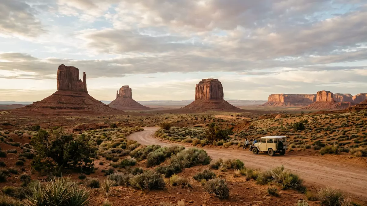
Monument Valley lies near Oljato in the high desert of the Colorado Plateau, where isolated sandstone towers rise above a broad, dusty basin on Navajo land. The valley’s buttes record Permian and Triassic geology in stacked bands of red and brown rock that stand above the surrounding floor.
A desert basin of mesas and buttes
Monument Valley occupies part of the Colorado Plateau on the Arizona–Utah border, with the tribal park managed as Monument Valley Navajo Tribal Park near Oljato in Utah.Monument Valley Navajo Tribal Park The valley floor sits at a high elevation, framed by flat-topped mesas and isolated buttes that rise above a largely open desert plain.valley floor elevation
Each major sandstone tower shows a stepped profile, with broad lower slopes leading to near-vertical cliffs and flatter tops protected by harder rock. The landscape combines mesas with wide upper surfaces and narrower buttes rising in isolation, giving the valley its scattered skyline of stone.
Layered rock and deep geological time
The towers in Monument Valley expose three main rock units, with Organ Rock shale at the base, de Chelly sandstone in the middle and Moenkopi shale forming the upper cap.three distinct geological layers These layers span environments that ranged from floodplains to wind-blown dune fields and shallow water settings tied to the Permian and Triassic periods.Organ Rock, de Chelly and Moenkopi
The lower slopes consist mainly of Organ Rock shale, a softer mudstone and siltstone deposited on ancient floodplains, while the central cliffs are carved in massive de Chelly sandstone laid down as dunes.Organ Rock shale and de Chelly sandstone Above them, Moenkopi shale forms thinner bands and caps, with resistant lenses such as Shinarump conglomerate helping to protect the tops from rapid erosion.Moenkopi shale and Shinarump conglomerate
Erosion shaping the valley’s skyline
Long before the present landscape, this part of the plateau formed a lowland basin where sediments from ancestral mountain ranges accumulated over hundreds of millions of years.lowland basin filled with sediment Tectonic uplift raised these horizontal strata well above sea level, creating the plateau. Over roughly the last 50 million years, streams, rain and wind cut into the uplifted rock, peeling away softer material and leaving behind the towers, mesas and pinnacles seen across the valley floor.erosion of sedimentary rock
The colour palette is dominated by reds and oranges linked to iron oxide in the weathered sandstone and siltstone, with darker streaks on some cliffs associated with manganese-rich coatings.iron and manganese oxide colours Against the relatively flat basin, the isolated rock forms create a skyline of discrete silhouettes, each shaped by differential erosion along joints, bedding planes and contrasts between softer and harder layers.
Named formations and Navajo Tribal Park setting
The valley’s best-known rock features include the East and West Mitten Buttes, Merrick Butte, the Three Sisters and the slender Totem Pole and Yei Bi Chei pinnacles.headline formations such as the Mittens The Mittens stand near the entrance to the park and frame views from the main overlook, while other formations such as John Ford Point and Ear of the Wind lie deeper in the desert around the valley drive.
Monument Valley forms part of Navajo land and is officially managed as Monument Valley Navajo Tribal Park, with a visitor centre near Oljato on the Utah side.visitor centre near Oljato The tribal park status reinforces its role as both a lived-in landscape and a protected area, where sandstone towers, mesas and open desert floor create a characteristic view of the American Southwest.
Visiting Monument Valley: what travellers from Western Europe should know
- Monument Valley Navajo Tribal Park straddles the Arizona–Utah border, with the main access road leading east from U.S. Route 163 near Oljato.
- The valley floor is an open desert basin at high elevation, with unshaded stretches on packed earth and sand and viewpoints reached along graded tracks.
- Named formations such as the East and West Mitten Buttes and Merrick Butte are visible from the main overlook near the visitor centre without leaving the immediate area.
- The official language on Navajo land is English alongside Navajo, and the currency is the United States dollar.
- Entry requirements depend on your nationality; UK travellers can check the FCDO travel advice at gov.uk/foreign-travel-advice, Irish travellers the Department of Foreign Affairs at ireland.ie.
Searching for Monument Valley on social platforms
These links open searches for Monument Valley on each platform.
Frequently asked questions about Monument Valley
Where is Monument Valley located?
Monument Valley lies on the Colorado Plateau along the Arizona–Utah border, with Monument Valley Navajo Tribal Park reached from U.S. Route 163 near Oljato.
What should travellers expect on a visit?
Travellers encounter a high desert basin with an open red valley floor, sandstone mesas and buttes, graded tracks and viewpoints that look towards named formations such as the Mittens.
What makes Monument Valley distinctive?
Monument Valley is distinctive for its isolated sandstone towers and mesas rising from a broad basin, exposing layered rock from the Permian and Triassic periods.


