
Jokulsarlon glacier lagoon on Iceland’s south coast
Published on 09/12/2026 at 15:41 | Editorial responsibility: Rafael Müller, Editor-in-Chief AD HOC NEWS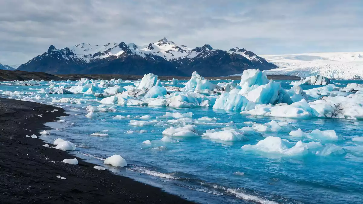
Jokulsarlon is a glacier?fed lagoon in south?east Iceland, between Hofn and Skaftafell where broken ice from the Breidamerkurjokull glacier drifts across deep water on the coastal plain.
Icebergs adrift beneath Vatnajokull
Jokulsarlon lies in the southern part of Vatnajokull National Park, at the foot of the Breidamerkurjokull outlet glacier on the low?lying sands of Breidamerkursandur.southern part of Vatnajokull National Park The ice front has retreated inland and left a basin filled with glacial meltwater where large pieces of ice continually calve from the glacier and drift out across the lagoon.icebergs drift across deep, dark water
The lagoon is recognised as Iceland’s deepest lake, reaching about 248 m (814 ft) at its deepest soundings and covering roughly 25 km² (9.7 sq mi).deepest lake in Iceland It began forming in the 1930s as Breidamerkurjokull retreated and has expanded markedly since the 1970s as the glacier has continued to pull back from the Atlantic coast.lagoon started forming around 1935 Standing on the shore, the scale of the water and the ice makes clear that Jokulsarlon is a young but substantial landscape feature rather than a small meltwater pond.
From glacier face to Atlantic shore
Jokulsarlon sits directly beside Iceland’s Route 1, the Ring Road, on the coastal plain between Skaftafell and Hofn, with the glacier face to the north and the Atlantic beyond the sandur to the south.sits directly on Route 1 Viewpoints, parking areas and boat jetties line the lagoon’s edge, giving close sight of the icebergs that have broken off from Breidamerkurjokull and drift slowly towards the narrow tidal channel at the seaward end.glacial river that cuts across the sandur
A short glacial river links Jokulsarlon with the Atlantic Ocean, cutting across the black sands where ice fragments strand on the shore at what travellers know as Diamond Beach.icebergs sparkle like diamonds Seawater mixes with freshwater in the lagoon, so seals are regularly seen using the floating ice as resting places while moving between the open sea and the calmer waters among the bergs.mix of fresh and salt water The juxtaposition of glacier, lagoon, tidal river and ocean within a relatively compact area makes Jokulsarlon one of the clearest places in Iceland to observe how ice, water and coast interact.
A young lagoon shaped by retreating ice
Jokulsarlon carries an Icelandic name meaning “glacial river lagoon”, a literal description of how meltwater from Breidamerkurjokull collects and drains seaward.literally means “glacier lagoon” The lagoon is a twentieth?century creation, with the basin developing as the glacier tongue withdrew from the shoreline and meltwater filled the depression left behind.developed into a lake after the glacier started receding Satellite imagery and field measurements from agencies such as NASA show that Jokulsarlon has grown several?fold in area over a few decades as the ice has thinned and retreated inland.quadrupled in size since the 1970s
The blocks of ice that populate the lagoon range from small fragments to bergs comparable in height to a multi?storey building, and many contain ice more than 1,000 years old drawn from the deep layers of Vatnajokull’s accumulation zone.ice more than 1,000 years old Fine glacial silt suspended in the water scatters light and gives Jokulsarlon its characteristic milky?blue colouring, while bands of volcanic ash inside the ice record earlier eruptions under the ice cap.turquoise color comes from glacial silt The lagoon therefore functions as a visible archive of both climatic change and volcanic activity on Iceland’s south coast.
Visiting Jokulsarlon: what travellers from Western Europe should know
- Jokulsarlon lies in south?east Iceland beside Route 1 on Breidamerkursandur, roughly between Skaftafell and Hofn, with the lagoon clearly visible from the Ring Road.
- The terrain around the shore consists of uneven gravel and sand with short slopes, and access to viewpoints generally involves walking a short distance from parking areas.
- The nearest town with a range of services is Hofn to the east, linked by the Ring Road across the coastal plain.
- The official language is Icelandic and the currency is the Icelandic króna.
- Entry requirements depend on your nationality; UK travellers can check the FCDO travel advice at gov.uk/foreign-travel-advice, Irish travellers the Department of Foreign Affairs at ireland.ie.
Searching for Jokulsarlon on social platforms
These links open searches for Jokulsarlon on each platform.
Frequently asked questions about Jokulsarlon
Where is Jokulsarlon located in Iceland?
Jokulsarlon is on Iceland’s south?east coast within Vatnajokull National Park, beside Route 1 between Skaftafell and the town of Hofn.
What can visitors expect to see at Jokulsarlon?
Visitors see a deep glacier lagoon filled with drifting icebergs, the snout of Breidamerkurjokull, seals in the water and stranded ice on the nearby black?sand beach.
What makes Jokulsarlon distinctive among Icelandic landscapes?
The combination of a young, deep glacial lagoon, its direct connection to the Atlantic and the close relationship between glacier, river and ocean makes Jokulsarlon distinctive.


