
Grachten van Amsterdam and the seventeenth?century canal ring
Published on 09/09/2026 at 08:32 | Editorial responsibility: Rafael Müller, Editor-in-Chief AD HOC NEWS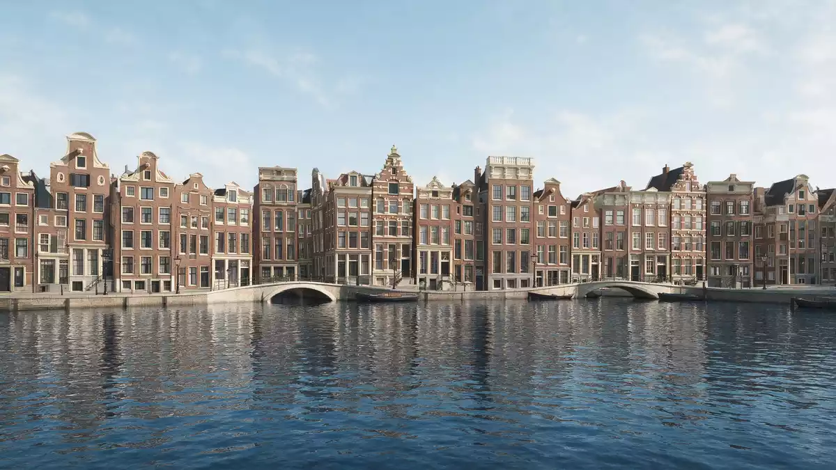
Grachten van Amsterdam are the canals that frame Amsterdam’s historic centre, forming a seventeenth?century ring of waterways and streets laid out during the Dutch Golden Age. In 2010 this canal ring, officially recognised as the Seventeenth?Century Canal Ring Area of Amsterdam inside the Singelgracht, was inscribed on the UNESCO World Heritage List, sealing its status as a planned urban landscape of international importance.Seventeenth?Century Canal Ring Area of Amsterdam inside the Singelgracht
A horseshoe of seventeenth?century water and brick
The core of Grachten van Amsterdam is the Grachtengordel, a belt of seventeenth?century canals that arcs in a horseshoe around the medieval city centre. Four named waterways define this ring: Singel, Herengracht, Keizersgracht and Prinsengracht, laid out as concentric curves west and south of the old town and harbour.Herengracht, Keizersgracht and Prinsengracht Singel marks the transition from the older core to the canal district, while the three inner canals carry long rows of canal houses facing the water.
Planning for the canal ring began around 1610, with large?scale works to drain swampland and extend the city. The main canals west and south of the old town were dug from 1613 onwards, and the expansion reached completion around the middle of the seventeenth century.built between 1613 and 1660 The result is a unified urban landscape where brick townhouses, tree?lined quays and water form a repeating pattern along the arcs.
Canal houses, bridges and the UNESCO?listed streetscape
Along Grachten van Amsterdam, especially on Herengracht, Keizersgracht and Prinsengracht, continuous terraces of canal houses stand on narrow plots, their tall facades facing directly onto the water and street. Many of these houses date from the seventeenth and early eighteenth centuries and together form a largely intact historic streetscape; around 1,500 of them are protected monuments within the UNESCO?listed area.~1,550 historic monuments Gables in a range of Dutch styles, warehouse hoists and tall windows are typical features along these canals.
The canal network itself extends for more than 100 km (62 mi) and is crossed by numerous bridges linking the islands and peninsulas created by the waterways.more than 100 kilometres of canals Within the ring, cross?canals such as Brouwersgracht and Reguliersgracht connect the main arcs, while radial streets run down to the water. Together this layout produces a fine?grained grid of streets and canals that remains legible on any map of Amsterdam.
From planned expansion to lived?in cityscape
Grachten van Amsterdam emerged from a deliberate seventeenth?century expansion programme that combined land reclamation, water management and new residential districts. The UNESCO?listed canal ring inside the Singelgracht covers around 650 hectares of historic city, including parts of the Jordaan and the medieval centre, and stands as a large?scale example of coordinated urban planning in early modern Europe.around 650 hectares inside the Singelgracht The pattern of canals and streets laid down in the seventeenth century still structures daily life in the district.
Within this area, the three principal canals — Herengracht, Keizersgracht and Prinsengracht — form the main residential belt, while Singelgracht defines the outer limit of the historic expansion and carries water and traffic around it.Herengracht, Keizersgracht, Prinsengracht and Singel The canal ring was recognised by UNESCO under criteria including creative urban design and the integration of hydraulic engineering into a densely built city.
Visiting Grachten van Amsterdam: what travellers from Western Europe should know
- Grachten van Amsterdam surround the historic centre of Amsterdam in the Netherlands, with the main canal ring lying west and south of the medieval core and harbour.
- The canal district is largely flat, but many bridges and canal?side streets have kerbs and short flights of steps between street level, quays and house entrances.
- The seventeenth?century canal ring inside the Singelgracht sits close to districts such as the Jordaan and the old harbour, making it possible to combine canal walks with visits to these neighbourhoods.
- The official language is Dutch and the currency is the euro.
Searching for Grachten van Amsterdam on social platforms
These links open searches for Grachten van Amsterdam on each platform.
Frequently asked questions about Grachten van Amsterdam
Where are Grachten van Amsterdam located?
Grachten van Amsterdam are the canals in Amsterdam’s historic centre in the Netherlands, with a seventeenth?century ring encircling the old medieval core.
What can travellers expect when exploring the canals?
Travellers encounter long stretches of water lined with historic brick townhouses, crossed by bridges and intersected by cross?canals that reveal the planned seventeenth?century layout.
What makes Grachten van Amsterdam distinctive?
The canal ring combines a concentric pattern of waterways, seventeenth?century canal houses and a formally recognised UNESCO World Heritage urban landscape built during the Dutch Golden Age.


