
Centro Historico de Cuenca, an Andean grid of rivers, plazas and domes
Published on 08/30/2026 at 14:36 | Editorial responsibility: Rafael Müller, Editor-in-Chief AD HOC NEWS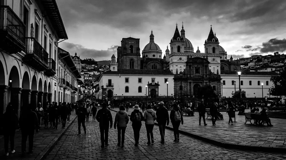
Centro Historico de Cuenca is the historic core of Santa Ana de los Ríos de Cuenca in southern Ecuador, laid out on a planned grid across a highland plateau bordered by rivers such as the Río Tomebamba. Recognised as the Historic Centre of Santa Ana de los Ríos de Cuenca by UNESCO in 1999, it gathers centuries of Andean urban life into a compact fabric of streets, plazas and low-rise buildings.
An Andean city planned between rivers
Cuenca was founded on 12 April 1557 under the full name Santa Ana de los Ríos de Cuenca, a label that signals how closely the city is tied to its waterways.Santa Ana de los Ríos de Cuenca The historic centre occupies the plateau where the early town grew, bounded by rivers that cut green corridors below the built-up streets and mark the transition from dense urban blocks to open slopes.
The street pattern follows a rectilinear grid imposed under Spanish colonial rule, with straight streets meeting at regular junctions and aligning with principal squares.Historic Centre of Santa Ana de los Rios de Cuenca Within this grid, the UNESCO-recognised historic centre covers more than 200 ha of urban fabric and archaeological zones, extending over the area occupied by the town until the first half of the twentieth century.the area recognised by UNESCO
Plazas, churches and republican façades
Centro Historico de Cuenca concentrates colonial and republican-era architecture in streets where religious, civic and residential buildings sit side by side. Around Parque Calderón, the main square of the city, large churches and civic buildings frame the open space, their façades rising above cobbled streets and small trees.Parque Calderón, the main square Several churches display baroque and neoclassical elements adapted to local tastes, with towers, domes and ornamented entrances marking them out against plainer residential blocks.churches and convents showcase variations
Residential streets are lined with two- and three-storey townhouses whose stucco façades, timber balconies and heavy doors conceal internal courtyards.two- and three-storey townhouses Many buildings combine solid masonry at ground level with lighter construction above, reflecting the way local materials and later European influences were incorporated into Andean conditions. Beyond the houses, markets and artisan quarters continue older patterns of use, with streets such as Bolívar, Sucre and Hermano Miguel forming part of the historic zone described in Ecuadorian heritage registers.streets forming the historic zone
World Heritage status and layered heritage
The historic centre of Cuenca was declared “Patrimonio Cultural del Ecuador” in March 1982, reflecting its concentration of heritage buildings, archaeological remains and cultural practices.Patrimonio Cultural del Ecuador On 1 December 1999, UNESCO inscribed the Historic Centre of Santa Ana de los Ríos de Cuenca on the World Heritage List for conserving the original grid since its sixteenth-century foundation and for the way the ensemble illustrates Spanish colonial town planning in the Andes.UNESCO recognised the city
Within the inscribed area, archaeological sites such as Pumapungo and historic access corridors recall earlier phases of settlement and movement around the plateau.includes the archaeological site of Pumapungo The Centro Historico de Cuenca therefore preserves an ensemble where colonial and republican architecture, archaeological zones and riverside landscapes combine in a single contiguous district, making its heritage status a property of the whole urban fabric rather than of isolated monuments.a surface total that sums 224 hectares
Visiting Centro Historico de Cuenca: what travellers from Western Europe should know
- Centro Historico de Cuenca occupies the central part of Cuenca in Azuay Province in southern Ecuador and is reached by road from Cuenca’s airport and intercity bus terminals, which connect the Andean highlands with other regions.
The historic streets lie between rivers such as the Río Tomebamba, where higher terraces give way to paths closer to the water.on a highland plateau bordered by rivers such as the Río Tomebamba - The historic centre consists of cobbled streets, pavements and occasional slopes down towards the rivers; several routes involve staircases or uneven surfaces, particularly near the Barranco del Tomebamba, where streets step down from the plateau to riverside walks.el Barranco del Tomebamba con el Paseo 3 de Noviembre
- The official language is Spanish and the currency is the US dollar.
- Centro Historico de Cuenca lies in Ecuador outside the UK, Ireland and the EU. Entry requirements depend on your nationality; UK travellers can check the FCDO travel advice at gov.uk/foreign-travel-advice, Irish travellers the Department of Foreign Affairs at ireland.ie.
Searching for Centro Historico de Cuenca on social platforms
These links open searches for Centro Historico de Cuenca on each platform.
Frequently asked questions about Centro Historico de Cuenca
Where is Centro Historico de Cuenca?
Centro Historico de Cuenca is the historic centre of the city of Cuenca in Azuay Province in southern Ecuador, occupying a highland plateau bordered by rivers such as the Río Tomebamba.occupies the historic core of the city of Cuenca in Azuay Province, southern Ecuador
What should visitors expect on a walk through the historic centre?
Visitors encounter a planned grid of cobbled streets, plazas framed by churches and civic buildings, and rows of townhouses with stucco façades and timber balconies, along with riverside paths below the plateau.its historic core is organized around plazas and a rectilinear street plan
What makes Centro Historico de Cuenca distinctive among Andean cities?
Centro Historico de Cuenca stands out for its Renaissance-inspired colonial grid preserved since the sixteenth century, its combination of colonial and republican architecture, and its recognition as a UNESCO World Heritage site since 1999.obtained recognition for conserving the grid


