
Aillte an Mhothair: Atlantic cliffs at the edge of the Burren
Published on 09/08/2026 at 10:35 | Editorial responsibility: Rafael Müller, Editor-in-Chief AD HOC NEWS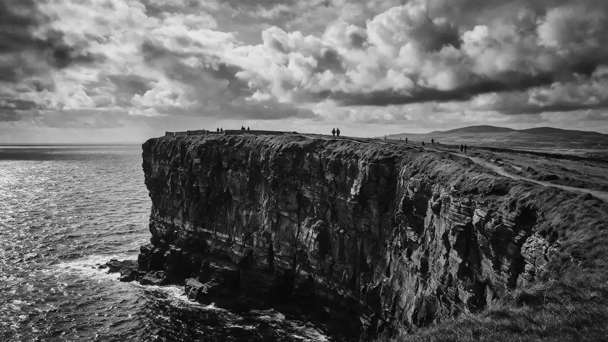
Aillte an Mhothair, on the Atlantic coast near Liscannor in County Clare, is a stretch of sea cliffs where the Burren limestone plateau ends abruptly in a wall of rock above the ocean. Rising to over 200 m (656 ft) in places, these cliffs form one of Ireland’s most striking coastal edges and frame long views over water and stone towards the wider west of Ireland.
Aillte an Mhothair and the Burren plateau
Aillte an Mhothair occupies the south-western margin of the Burren region, a landscape of exposed limestone that extends inland as a patchwork of rocky terraces and fields.the Burren region At the coast, this plateau breaks into cliffs that run along the shore, their faces marked by horizontal layers of rock stacked above the Atlantic.
The cliffs form the ocean-facing edge of the Burren and are part of the wider Burren and Cliffs of Moher UNESCO Global Geopark, which links the coastal escarpment with the inland limestone hills.Burren and Cliffs of Moher UNESCO Global Geopark Inland from the brink, the ground rises in a series of rocky fields and pavements, while offshore the Atlantic stretches towards the Aran Islands and the broader ocean.
Scale, form and coastal geography
Aillte an Mhothair forms a coastal line of cliffs that extends for roughly 14 km (8.7 miles) along the western edge of County Clare between Hag’s Head in the south and higher sections near O’Brien’s Tower in the north.extends for roughly 14 km At their southern end near Hag’s Head, the cliffs rise to around 120 m (390 ft) above the Atlantic, then gain height towards the central and northern stretches where the rock stands at about 214 m (702 ft) above the water.about 214 m above the ocean
The cliff faces are composed largely of limestone and shale, with layers that weather into ledges, vertical drops and occasional grassy shelves.limestone and shale cliffs Waves break against the base of the escarpment, sending spray upwards, while above, the plateau carries paths and fields close to the edge, giving a clear sense of how land and sea meet along this part of County Clare.
O’Brien’s Tower and the cliff-top experience
Near the midpoint of Aillte an Mhothair stands O’Brien’s Tower, a stone tower built in 1835 by Sir Cornelius O’Brien, a local landlord and Member of Parliament for Clare.O’Brien’s Tower built in 1835 The tower occupies a prominent position close to some of the highest sections of the cliffs and serves as a viewpoint on the cliff-top.
The wider cliff-top area near O’Brien’s Tower includes paths along the edge and views inland towards the Burren and out across the Atlantic towards the Aran Islands.views towards the Aran Islands From these points, the layered rock faces of Aillte an Mhothair can be seen stepping away along the coast, with changes in height and profile marking the different sections between Hag’s Head and the northern stretches.
Visiting Aillte an Mhothair: what travellers from Western Europe should know
- Aillte an Mhothair lies on the Atlantic coast of County Clare in Ireland, west of Liscannor, and is reached by road routes that approach the cliffs from towns such as Ennis and from the wider direction of Galway.
- The terrain along the cliff-top includes gradients and uneven ground, and in places paths run close to steep drops where the cliffs fall to the Atlantic far below.
- In windy or wet weather the exposed coastal position can make the cliff-top feel very open, with strong gusts and spray reaching higher sections.
- The official language is Irish and English and the currency is the euro.
Searching for Aillte an Mhothair on social platforms
These links open searches for Aillte an Mhothair on each platform.Frequently asked questions about Aillte an Mhothair
Where is Aillte an Mhothair?
Aillte an Mhothair is on Ireland’s Atlantic coast in County Clare, near the village of Liscannor and at the south-western edge of the Burren limestone region.
What should visitors expect at the cliffs?
Visitors encounter high sea cliffs with layered rock faces, exposed coastal weather and long views over the Atlantic and the inland Burren plateau.
What makes Aillte an Mhothair distinctive?
The combination of its height above the Atlantic, its limestone and shale geology and its position at the edge of the Burren makes Aillte an Mhothair a distinctive coastal landscape.


