
Zocalo, the vast civic square at the heart of Mexiko-Stadt
Published on 08/26/2026 at 15:48 | Editorial responsibility: Rafael Müller, Editor-in-Chief AD HOC NEWS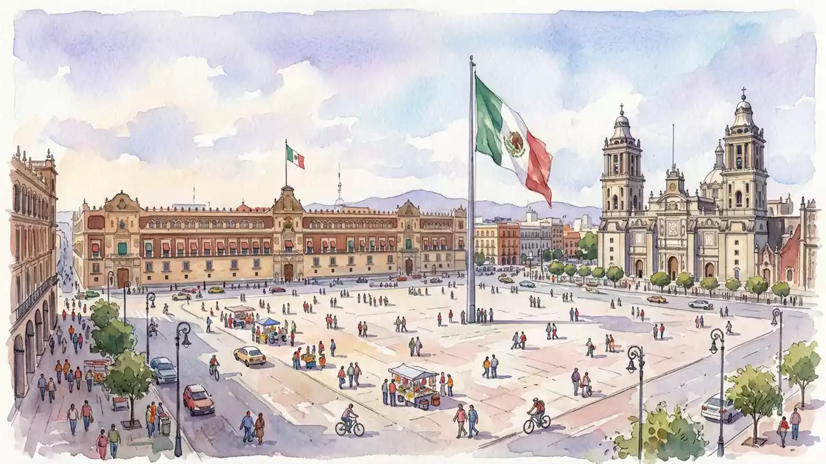
Zocalo in Mexiko-Stadt, formally known as Plaza de la Constitución, is the great open square at the core of Mexico City’s historic centre, a paved expanse framed by monumental façades on every side.
The scale and layout of Mexico City’s main square
Zocalo is a broad, hard-surfaced plaza laid out as a single open rectangle, with minimal permanent structures interrupting its surface. Across its length and breadth, the square stretches for well over 200 m (656 ft) in each direction, making it one of the largest city-centre squares in the Spanish-speaking world.one of the largest city squares The paving runs uninterrupted to the surrounding streets, so that the square reads as a single plane of stone in the midst of the dense street grid of the Centro Histórico.
In the middle of Zocalo stands a tall flagpole carrying a single, outsized Mexican flag, a vertical marker rising from the horizontal surface of the square.a single enormous flagpole Around the edges, street crossings and kerbs mark the transition from the plaza to the surrounding roadways, but there are no permanent fences enclosing the space. The result is a vast, continuous surface that can be crossed diagonally in any direction, giving a clear sense of the square’s sheer size.
Architecture and institutions around the plaza
Zocalo is defined as much by the buildings that surround it as by the open ground itself. On the north side rises the Metropolitan Cathedral, a long stone church whose multiple towers and chapels face directly onto the square, forming a richly articulated façade above the paving.the Metropolitan Cathedral to the north To the east stands the Palacio Nacional, the long presidential and governmental complex that occupies an entire side of the plaza with its arcades, windows and balconies.the National Palace on the east side
The south side is lined with government offices belonging to the city administration, their façades forming a continuous wall of civic architecture facing the open square.city government offices to the south Just beyond the west side of the plaza lie streets leading towards the Palacio de Bellas Artes and other notable buildings of the Centro Histórico, while close to the north-east corner the remains of the Aztec Templo Mayor stand slightly recessed behind the building line.Templo Mayor near the square The effect is that Zocalo functions as a forecourt to religious, governmental and archaeological landmarks at once.
From Aztec ceremonial centre to Plaza de la Constitución
The ground now occupied by Zocalo formed the ceremonial centre of the Aztec capital Tenochtitlan, a place of temples and platforms at the heart of the island city in the basin of Mexico.centre of Tenochtitlan After the Spanish conquest in the sixteenth century, the colonial authorities laid out a main square on the same site, which became known as Plaza Mayor and Plaza de Armas, taking shape as the civic centre of colonial Mexico City.
In the nineteenth century the square received its formal name, Plaza de la Constitución, in honour of the Constitution of Cádiz promulgated in 1812.named after the Constitution of Cádiz The popular name “Zocalo” dates from plans for a major independence monument whose pedestal, or zócalo, stood on the plaza even after the rest of the monument was never completed, a base that left its name to the whole square.the pedestal that gave the Zocalo its name Together with the surrounding streets, Zocalo forms part of the Centro Histórico of Mexico City, an area recognised internationally for its historic urban fabric.
Visiting Zocalo: what travellers from Western Europe should know
- Zocalo lies in the Centro Histórico district of Mexico City, within the Cuauhtémoc borough, with the plaza itself formally designated as Plaza de la Constitución.
- The square is a level paved expanse exposed to sun and weather, so crossing it on foot involves walking over open stone surfaces without shade or shelter for considerable distances.
- The “Zócalo/Tenochtitlan” station on Metro Line 2 sits directly beneath the square, with an exit emerging at the north-east corner onto the surrounding streets.
- Spanish is the official language and the currency is the Mexican peso.
- Entry requirements depend on your nationality; UK travellers can check the FCDO travel advice at gov.uk/foreign-travel-advice, Irish travellers the Department of Foreign Affairs at ireland.ie.
Searching for Zocalo on social platforms
These links open searches for Zocalo on each platform.Frequently asked questions about Zocalo
Where is Zocalo located within Mexiko-Stadt?
Zocalo occupies the central square of Mexico City’s Centro Histórico, in the Cuauhtémoc borough, and is formally designated Plaza de la Constitución.
What can visitors expect when they arrive at Zocalo?
Visitors step into a vast paved plaza dominated by a huge Mexican flag, bordered by the Metropolitan Cathedral, the National Palace and other civic buildings.
What makes Zocalo distinctive among city squares?
Zocalo stands out for its combination of sheer size, continuous open paving and its role as a shared forecourt to religious, governmental and pre-Hispanic landmarks.


