
Yaxha near Flores: a lakeside Maya city on a forested ridge
Published on 09/05/2026 at 07:58 | Editorial responsibility: Rafael Müller, Editor-in-Chief AD HOC NEWS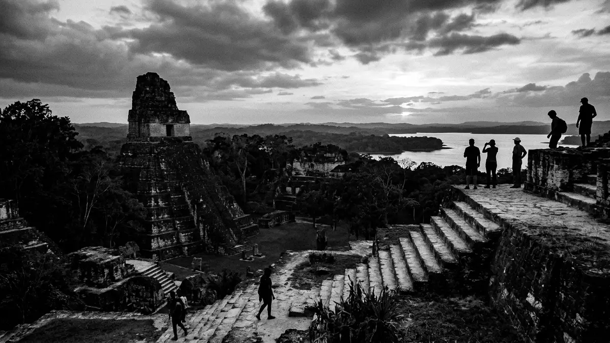
On the north shore of a broad lagoon in northern Guatemala, the ancient city of Yaxha stretches along a forested ridge, its stone plazas overlooking blue-green water and dense jungle. The site belongs to the Classic Maya world and lies in the Petén region east of Flores, where temples, palaces and causeways form a long urban spine parallel to Lake Yaxha.
A Maya city between lake and ridge
Yaxha is a Mesoamerican archaeological site in the northeast of the Petén Basin, in northern Guatemala, and once served as a ceremonial centre and city of the pre-Columbian Maya civilisation.a Maya site in Petén The ruins extend along a hilltop facing Lake Yaxha, part of the eastern Petén lakes, giving the city an elongated plan that follows the ridge rather than forming a compact cluster. In the Classic period, the urban core contained plazas framed by temples and palaces, ball courts for ritual games and residential groups, connected by causeways running along the higher ground.
The name “Yaxha” is commonly translated from Maya as “blue-green water”, a reference to the colour and presence of the lake that defines the setting.Yaxha meaning blue green water The site forms part of the Yaxha-Nakum-Naranjo National Park, a large protected area that combines archaeology with subtropical rainforest and wetlands.Yaxha-Nakum-Naranjo National Park From the higher structures, visitors look out over the lagoon and the forest canopy, with further Maya centres such as Nakum and Naranjo lying within the same protected landscape.
History and layout of Yaxha
Archaeological research places occupation at Yaxha from the Preclassic period, with the city developing strongly through the first millennium AD as part of the wider Classic Maya world.occupation since the Preclassic period Excavations and mapping indicate around 500 structures in the site centre, stretched over several kilometres of ridge line between the lake and the surrounding lowlands.about 500 structures along the ridge These include stepped pyramids, temple-platforms, residential compounds and administrative buildings, giving a sense of a substantial regional capital rather than a small outpost.
In the twentieth century, systematic archaeological projects documented the core of Yaxha and supported its integration into a protected national park.prehispanic occupation studies Consolidation has stabilised masonry and clarified routes through the main plazas, while much of the wider settlement remains covered by forest, with partially visible mounds showing the scale of the ancient city. Walks through the site alternate between open ceremonial spaces and shaded paths under tall trees, where stone platforms rise beside the track and occasional stelae stand near building groups.
Landscape, lakes and wildlife
The landscape around Yaxha is defined by water as much as by stone. The city stands on the north side of Lake Yaxha, a long lagoon that forms part of an interconnected chain of lakes and wetlands in central Petén.situated on the north shore of Lake Yaxha A second lagoon, Sacnab, lies nearby, and the archaeological site occupies the ridge between them, giving views over both bodies of water from certain elevated structures.a large picturesque site between lakes The ridge reaches around 168 m (551 ft) above the lake surface, enough to lift the main plazas above the water while keeping the approach relatively gentle.
Yaxha lies within the Yaxha-Nakum-Naranjo National Park, a subtropical rainforest preserve that supports a wide range of wildlife alongside the ruins.part of a trio of pre-Columbian cities Visitors walking between groups of buildings can encounter forest clearings, dense understorey and lagoon edges, with the sounds of birds and primates around the structures. The combination of ancient masonry, tree cover and inland lakes gives Yaxha a distinctive atmosphere compared with drier or more isolated Maya sites further west.
Visiting Yaxha: what travellers from Western Europe should know
- Yaxha lies in Guatemala’s Petén department, east of the town of Flores; road access uses the highway towards the Belize border, with a signed turn-off near La Maquina leading to the park entrance.east of Flores towards the Belize border
- The archaeological core stands on a ridge above Lake Yaxha, and visiting involves walking on uneven forest paths and climbing stone steps between plazas and temple groups.
- The wider archaeological zone forms part of the Yaxha-Nakum-Naranjo National Park, so forest, lagoons and other Maya sites such as Nakum and Naranjo lie within reach of the same access routes.part of Yaxha-Nakum-Naranjo National Park
- The official language is Spanish and the currency is the Guatemalan quetzal.
- Entry requirements depend on your nationality; UK travellers can check the FCDO travel advice at gov.uk/foreign-travel-advice, Irish travellers the Department of Foreign Affairs at ireland.ie.
Searching for Yaxha on social platforms
These links open searches for Yaxha on each platform.Frequently asked questions about Yaxha
Where is Yaxha located in relation to Flores?
Yaxha is in Guatemala’s Petén department, east of Flores, reached by the main road towards the Belize border and a signed turn-off near La Maquina.
What can visitors expect when exploring Yaxha?
Visitors walk through forest between plazas, temples and palaces on a ridge above Lake Yaxha, with extensive ruins and lagoon views from higher structures.
What makes Yaxha distinctive among Maya sites?
Yaxha combines a large Classic Maya city of around 500 mapped structures with a lakeside setting in a protected rainforest park that also includes Nakum and Naranjo.


