
Yaxha: a Maya city between lake and rainforest
Published on 09/07/2026 at 16:05 | Editorial responsibility: Rafael Müller, Editor-in-Chief AD HOC NEWS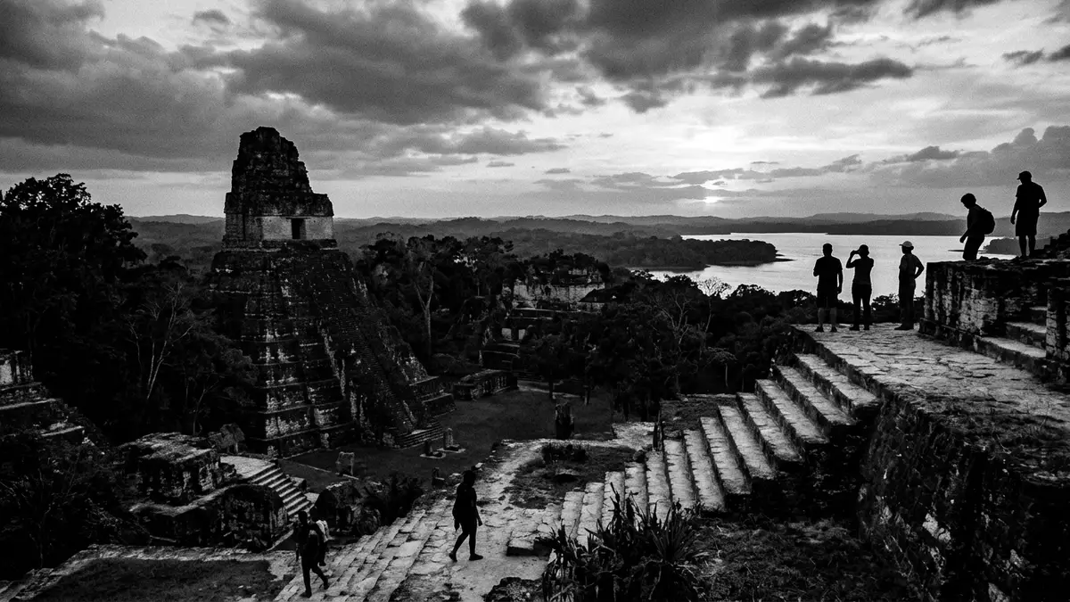
On a long limestone ridge above a green lake in northern Guatemala, Yaxha preserves the outlines of a substantial Maya city within dense rainforest. The ruins lie in the Petén department east of Flores and stand on the north shore of Lake Yaxha, where plazas, pyramids and palaces stretch for several kilometres along the slope.
A lakeside Maya city in the Petén forest
Yaxha occupies a series of hilltops overlooking Lake Yaxha, part of a chain of water bodies in central Petén that once linked river routes and settlements across the region.Situated on the north shore of Lake Yaxha, the site lies roughly south-east of Tikal and close to the border with Belize.Yaxha in Guatemala’s Petén region The ancient city forms the largest component of the Yaxha-Nakum-Naranjo National Park, a protected area of forest and wetlands that includes other major ruins such as Nakum and Naranjo.
The name Yaxha comes from a Maya term meaning blue-green or green water, a reference to the colour of the lake that fills the basin below the ridge.The name is one of the few original Maya toponyms still in use From the higher platforms it is possible to look out over the lake and surrounding forest canopy, with other low ridges rising beyond the water. Despite its size, the site lies in comparatively remote countryside east of Flores and does not sit beside a town or village, so the dominant surroundings remain woodland and water.
Architecture on a ridge: plazas, pyramids and acropoleis
The core of Yaxha consists of plazas lined by temple pyramids and palace ranges, linked by raised stone causeways known as sacbeob that run along and across the ridge.Causeways connect central, northern and eastern acropoleis The site contains more than 500 documented structures, including substantial temple platforms that rise above the plaza level, residential complexes arranged around courtyards and administrative buildings grouped on elevated terraces.Yaxha has nine plazas and over 500 buildings Several of the pyramids reach a height at which the forest canopy falls below their summit, providing broad views across the reserve.
Visitors encounter a series of acropoleis, or clusters of monumental architecture on raised platforms, arranged along the ridge rather than concentrated in a single core. This layout reflects the underlying topography, with the city extending for about 3 km (1.9 mi) parallel to the lake shore.The ruins extend roughly 3 kilometres along the hilltop Among the structures identified so far are temple pyramids, palaces, carved stelae, altars and at least two ball courts for the Mesoamerican ballgame, giving the site a full range of ceremonial and civic spaces typical of a major Classic-period Maya city.
History of a Classic Maya centre
Archaeological evidence places occupation of Yaxha as early as the Preclassic period, with settlement from around the middle of the first millennium BC and substantial growth through the first millennium AD.The site has been occupied since the Preclassic period The city developed into one of the principal centres of the central Petén, with a long sequence of construction and remodelling in the plazas and acropoleis. Its monuments and inscriptions show connections with other Maya powers of the region, including Tikal and Naranjo, and place it within the broader network of Classic Maya politics and trade.
Yaxha remained a significant urban centre for many centuries, with the main phases of monumental building spanning the early and late Classic periods before decline and abandonment around the end of the first millennium AD.Yaxha ranks as the third-largest Maya site in the Petén Archaeological work during the twentieth century stabilised and documented many of the structures, and the designation of the Yaxha-Nakum-Naranjo National Park in 2003 gave the ruins formal protection within a wider biosphere reserve.
Visiting Yaxha: what travellers from Western Europe should know
- Yaxha lies in the Petén department of northern Guatemala, east of Flores and towards the road leading to the Belize border; access is usually by road from Flores.
- The archaeological area stands on a ridge above Lake Yaxha, and visiting the main pyramids and acropoleis involves walking on uneven stone surfaces and climbing stairways that can be steep in places.
- The surrounding forest is humid tropical woodland, and paths between groups of structures run through vegetation where shade alternates with exposed sections on plaza floors.
- The official language is Spanish and the currency is the Guatemalan quetzal.
- Entry requirements depend on your nationality; UK travellers can check the FCDO travel advice at gov.uk/foreign-travel-advice, Irish travellers the Department of Foreign Affairs at ireland.ie.
Searching for Yaxha on social platforms
These links open searches for Yaxha on each platform.
Frequently asked questions about Yaxha
Where is Yaxha and what is nearby?
Yaxha stands in the Petén department of northern Guatemala on a ridge above Lake Yaxha, east of Flores and towards the Belize border.
What can visitors expect on a visit to Yaxha?
A visit centres on walking through forest to reach plazas, temple pyramids and palace complexes, with the possibility of climbing structures that give views over the lake and canopy.
What makes Yaxha distinctive among Maya sites?
Yaxha combines a substantial concentration of Classic-period architecture with a lakeside setting, extensive sacbeob linking its acropoleis and a location within a large protected forest reserve.


