
Xunantunich: a hilltop Maya city above the Mopan River
Published on 08/31/2026 at 12:16 | Editorial responsibility: Rafael Müller, Editor-in-Chief AD HOC NEWS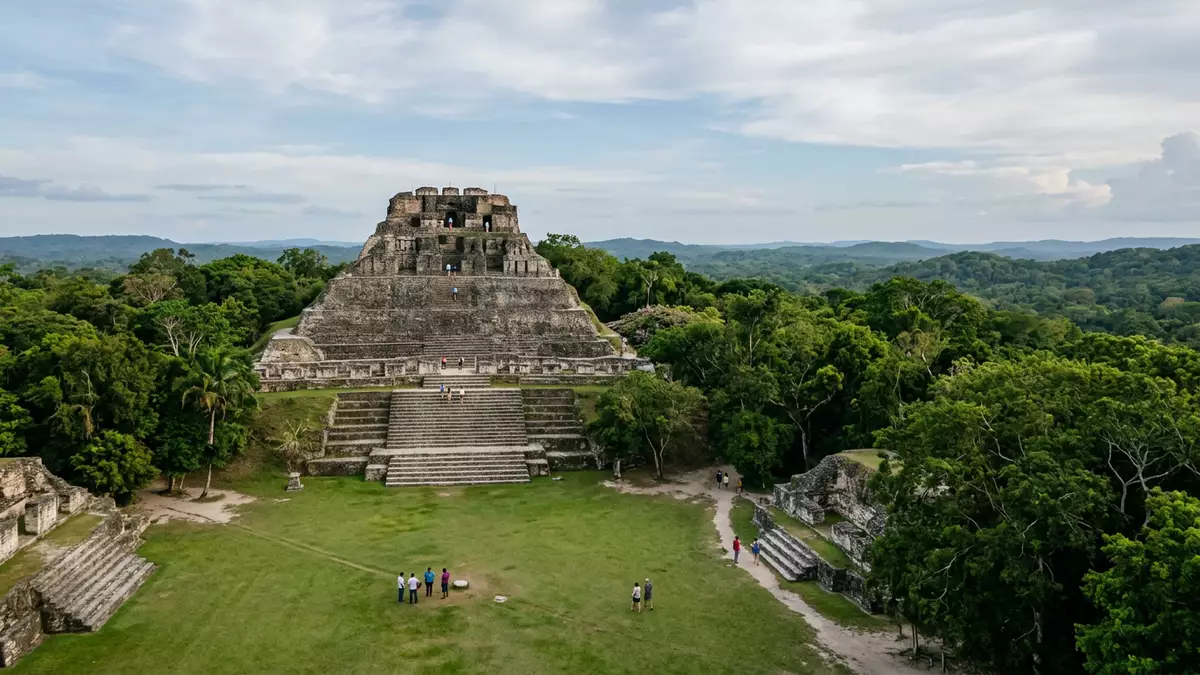
Xunantunich is an ancient Maya city in western Belize, reached from San Ignacio and set high on a ridge above the Mopan River near the village of San Jose Succotz. Its compact hilltop core, dominated by the El Castillo pyramid, gives visitors an unusually clear sense of a Classic-period ceremonial centre gathered around plazas and rising masonry.
El Castillo and the hilltop skyline
The central visual focus of Xunantunich is El Castillo, a stepped pyramid whose summit rises well above the surrounding forest and offers wide views across the Mopan valley and towards the Guatemala border.El Castillo is described in site guides as one of the tallest Maya structures in Belize, and its height relative to the other buildings on the ridge makes it the clear reference point for orientating yourself among the ruins.tallest Maya structures in the country
The pyramid stands within the group often referred to as Group A, the heart of the ancient city, where six plazas are framed by temples and palaces.six plazas surrounded by more than 26 temples and palaces Visitors climbing the broad terraces of El Castillo encounter carved friezes and Classic-period masks on its upper structures, a reminder that this was once a highly decorated ceremonial building rather than a bare stone monument.friezes and Classic period masks
A Late and Terminal Classic Maya centre
In historical terms, Xunantunich belongs firmly to the Late and Terminal Classic periods of Maya civilisation, when large regional centres were built and elaborated across the lowlands.Late and Terminal Classic periods Archaeological accounts place major construction at the site from around the seventh century AD onwards, with occupation attested between about 250 and 900 AD.occupation between 250 AD and 900 AD
The name Xunantunich itself is a modern Maya term meaning “Stone Woman” or “Maiden of the Rock”, drawn from Yucatec and Mopan Maya and linked to a local legend of a female apparition at the ruins in the nineteenth century.Stone Woman or Maiden of the Rock The ancient name of the city is not known, a situation shared by many excavated Maya sites where inscriptions are fragmentary or difficult to match to modern place-names.ancient name is currently unknown
Layout on a ridge above the Mopan River
Geographically, Xunantunich occupies a hilltop in the Cayo District of Belize, close to the Belize–Guatemala border and above the east bank of the Mopan River.Cayo District near the Guatemala border The ridge location means the site sits a short distance south-west of San Ignacio and is accessed from the village of San Jose Succotz, where travellers cross the river by a hand-operated cable ferry before following an uphill road to the parking area and entrance.hand-operated ferry and uphill road
The core of the site covers about one square mile and is organised into a series of plazas framed by temples, palaces and residential mounds, with groups labelled A to D by archaeologists for clarity.core about 1 square mile with 6 plazas and 26 structures The ruins lie within a forested setting, and the elevated position above the river gives a sense of separation from the surrounding farmland and settlements, even though the approach from the highway and the ferry makes it relatively straightforward to reach from San Ignacio and Belize City.ridge above the Mopan River
Visiting Xunantunich: what travellers from Western Europe should know
- Xunantunich lies south-west of San Ignacio in Belize’s Cayo District, reached along the Western Highway to San Jose Succotz and then by a hand-cranked ferry across the Mopan River.
- The approach from the ferry involves an uphill walk or vehicle ride on a dirt road, and movement within the site includes climbing broad stone stairways and terraces.
- The ruins sit close to the Belize–Guatemala border, with views over the surrounding forest and river valley from the higher structures.
- The official language of Belize is English and the currency is the Belize dollar.
- Entry requirements depend on your nationality; UK travellers can check the FCDO travel advice at gov.uk/foreign-travel-advice, Irish travellers the Department of Foreign Affairs at ireland.ie.
Searching for Xunantunich on social platforms
These links open searches for Xunantunich on each platform.
Frequently asked questions about Xunantunich
Where is Xunantunich located?
Xunantunich stands in Belize’s Cayo District near San Jose Succotz, south-west of San Ignacio and close to the Mopan River and the Guatemala border.
What should visitors expect on a visit?
Visitors encounter a compact hilltop Maya site with plazas, temples and palaces, approached via a ferry crossing and an uphill road, with substantial stone stairways within the ruins.
What makes Xunantunich distinctive among Maya sites?
The combination of a hilltop setting above the Mopan River, the prominence of the El Castillo pyramid and the clear arrangement of plazas and monumental structures gives Xunantunich a particularly legible layout.


