

Victoria Falls and the Zambezi’s vast curtain of water
Published on 08/26/2026 at 09:38 | Editorial responsibility: Rafael Müller, Editor-in-Chief AD HOC NEWS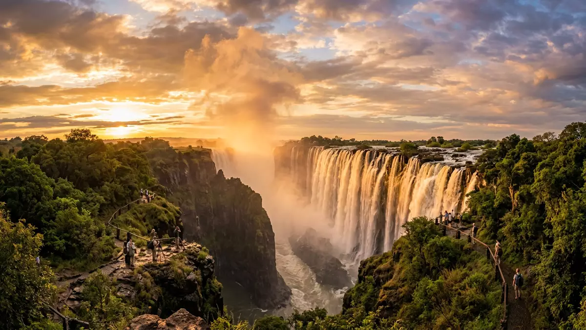
Victoria Falls is one of Africa’s great landmarks, where the Zambezi River plunges in a broad curtain of water between Zimbabwe and Zambia. Forming part of the Mosi-oa-Tunya / Victoria Falls World Heritage Site, it combines dramatic geology, powerful water and protected rainforest along a shared stretch of river.
The Zambezi River at the brink
Victoria Falls lies roughly midway along the course of the Zambezi River, at the point where the broad plateau gives way to a line of steep basalt gorges. The river flows across a relatively flat basalt surface before dropping into the first of these chasms, marking the transition between the upper and middle Zambezi at the border of Zimbabwe and Zambia.midway along the Zambezi River The waterfall stands at an altitude of around 900 m above sea level, so the lip of the falls sits high above the surrounding lowlands of southern Africa.altitude of about 915 m
Here the Zambezi narrows slightly yet remains wide enough for the water to form an almost continuous wall as it drops into the gorge. Basalt cliffs confine the flow, and the resulting sheet of falling water is broken only by islands and rock outcrops near the brink. A line of subsequent gorges carries the river away to the east, cutting a deep, winding channel through the plateau that contrasts with the broad calm of the upstream reach.
A vast sheet of falling water
The physical scale of Victoria Falls is one of its defining characteristics. The combined width of the cataracts is about 1,708 m (5,604 ft), and the water drops to a maximum depth of approximately 108 m (354 ft) into the gorge below, creating one of the world’s largest continuous curtains of falling water.1,708 m wide and 108 m high Measured by the combination of height and width, the falls form the largest single sheet of falling water known, with the river spanning the entire breadth of the cliff at this point.largest sheet of falling water
Along the lip of the precipice, the river is broken into several named sections, including Main Falls, Devil’s Cataract, Rainbow Falls, Horseshoe Falls and the Eastern Cataract on the Zambian bank.five different falls Across these segments the Zambezi drops over a cliff whose depth varies from around 70 m (230 ft) to more than 100 m (330 ft) where the gorge is deepest. The continuous drop and breadth combine to give the waterfall a scale that is rarely matched, with water streaming over basalt ledges in a long arc.
Mosi-oa-Tunya and protected rainforest
Local communities long knew the falls by indigenous names such as Mosi-oa-Tunya, often translated as “the smoke that thunders”, and Shungu Namutitima, “boiling water”, emphasising the spray and roar arising where the river meets the gorge.Mosi-oa-Tunya and Shungu Namutitima In the nineteenth century the Scottish missionary and explorer David Livingstone reached the site and named it Victoria Falls after Queen Victoria, a label that became widely used in English-language maps and accounts.David Livingstone named the falls in 1855
The falls and their immediate surroundings form a transboundary World Heritage Site that includes Mosi-oa-Tunya National Park in Zambia and Victoria Falls National Park and a riverine strip of Zambezi National Park in Zimbabwe, together covering 6,860 ha along the river corridor.transboundary World Heritage property Within this protected area sits a distinctive stretch of riverbank rainforest on the Zimbabwean side, fed by the persistent spray from the falls and contrasting with the drier woodland beyond.Victoria Falls National Park and rainforest
Visiting Victoria Falls: what travellers from Western Europe should know
- Victoria Falls lies on the Zambezi River along the border between Zimbabwe and Zambia, with the nearest towns being Victoria Falls in Zimbabwe and Livingstone in Zambia, both reached by regional road and air links.
- The main viewpoints on the Zimbabwean side are connected by paths that run close to the cliff edge, with sections involving steps and uneven, often wet, surfaces in a rainforest setting.
- The falls form part of a protected area that includes Mosi-oa-Tunya National Park and Victoria Falls National Park, so viewpoints are set among woodland and riverine habitats where wildlife may be encountered.
- The official languages are English in both Zimbabwe and Zambia, and the national currencies are the Zimbabwean dollar and the Zambian kwacha.
- Entry requirements depend on your nationality; UK travellers can check the FCDO travel advice at gov.uk/foreign-travel-advice, Irish travellers the Department of Foreign Affairs at ireland.ie.
Searching for Victoria Falls on social platforms
These links open searches for Victoria Falls on each platform.
Frequently asked questions about Victoria Falls
Where is Victoria Falls located?
Victoria Falls is on the Zambezi River at the border between Zimbabwe and Zambia, close to the towns of Victoria Falls in Zimbabwe and Livingstone in Zambia.
What can visitors expect when viewing the falls?
Visitors encounter a broad curtain of water dropping into a basalt gorge, with viewpoints along paths through spray-fed rainforest offering changing perspectives on the different cataracts.
What makes Victoria Falls distinctive among waterfalls?
The falls combine a width of about 1,708 m (5,604 ft) and a depth reaching around 108 m (354 ft), forming the world’s largest single sheet of falling water within a protected transboundary landscape.


