
Vesuvio above Neapel: Europe’s studied volcano
Published on 09/18/2026 at 21:27 | Editorial responsibility: Rafael Müller, Editor-in-Chief AD HOC NEWS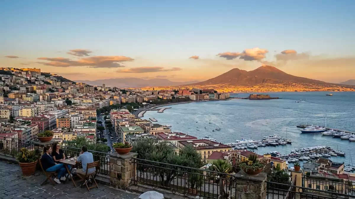
Vesuvio, known in English as Mount Vesuvius, rises above the Bay of Naples on the plain of Campania in southern Italy, forming a volcanic backdrop to Neapel and its coastal suburbs. The volcano’s present summit reaches around 1,281 m (4,203 ft), with a wide crater cut into the upper slopes that visitors can approach on foot. Its profile and surrounding protected landscape, designated as Parco Nazionale del Vesuvio in 1995, make Vesuvio a rare case of an active stratovolcano embedded directly in a densely settled European urban region.
A somma–stratovolcano overlooking the Bay of Naples
Vesuvio stands on the Gulf of Naples in Campania, a short distance east of the city of Naples and close to the Tyrrhenian coast. It occupies the eastern margin of the bay, with its flanks rising above towns such as Ercolano and Ottaviano that share the slopes and lower ridges.Mount Vesuvius in Campania The volcano is classified as a somma–stratovolcano, meaning that the present cone sits within the remnants of an older volcanic structure, sometimes referred to as Monte Somma, giving Vesuvio its characteristic double-rim profile when seen from certain angles.Somma–stratovolcano above the bay
The summit cone culminates at an elevation recorded at around 1,281 m (4,203 ft), with values in official material varying slightly because eruptions and erosion change the exact height over time.current height around 1,281 m The volcano forms the core of a national park of roughly 8,482 hectares that preserves lava fields, ash deposits and Mediterranean scrub across the upper slopes and adjacent ridges.Nationaal Park Vesuvius extent The crater itself is broad and steep-sided, with fumaroles venting on the inner walls and a walking path following the rim above the ash and rock of the cone.
Layers of eruption history and Roman destruction
Vesuvio’s reputation in European culture rests above all on the eruption in 79 AD that buried the Roman towns of Pompeii and Herculaneum under ash, pumice and pyroclastic flows. Archaeological excavations at these sites uncovered streets, villas and frescoes preserved under the volcanic deposits, creating an extensive record of daily life in a Roman coastal region.eruption of 79 AD That event fixed Vesuvio in the historical imagination as a destructive volcano towering above the bay, even as its slopes continued to be settled and cultivated in subsequent centuries.
The volcano has produced many eruptions since antiquity, with activity documented in historical sources and geological strata on the flanks. The last eruption in the twentieth century took place in 1944, when lava flows and explosive activity affected villages on the southern slopes and altered the shape of the cone.last eruption in 1944 Since that year the volcano has been in a quiescent phase, marked by fumarolic activity inside the crater and relatively low seismicity monitored by Italian observatories. The combination of long historical record and ongoing surveillance makes Vesuvio one of the most studied volcanoes on the European mainland.studied European volcano
Walking the crater paths of Parco Nazionale del Vesuvio
The establishment of Parco Nazionale del Vesuvio in 1995 created a structured framework for managing paths, vegetation and geological features on and around the volcano.national park founded in 1995 Within this park, a network of marked trails leads through old lava fields, pine plantations and areas of Mediterranean scrub towards viewpoints and the summit area. The Gran Cono path from the upper parking area climbs through cinders and compacted ash to the crater rim, where the ground drops away into the interior of the cone.
The terrain on the upper slopes is bare and rocky, with loose ash and small blocks underfoot and relatively limited shade along the exposed path. The crater rim path runs at altitude above 1,000 m (3,281 ft), and in places the park has installed wooden railings and simple interpretive boards about the volcano’s geology. Lower down, other trails cross vegetated slopes where broom, holm oak and other Mediterranean species colonise older deposits.geology and vegetation of Vesuvius The combination of crater paths and lower nature trails allows visitors to experience both the raw structure of the cone and the regenerating landscape on its flanks.
Visiting Vesuvio: what travellers from Western Europe should know
- Vesuvio rises above the Bay of Naples in southern Italy, and the main access roads approach from towns such as Ercolano and Ottaviano on the lower slopes.
- The climb from the upper parking area to the crater rim follows a compacted ash and gravel path with a steady gradient and sections of loose underfoot material.
- From Neapel’s central railway stations, regional trains on lines commonly referred to as Circumvesuviana serve Ercolano-Scavi and other foothill stations linked to shuttle services and taxis towards the park.
- The upper crater path sits at over 1,000 m (3,281 ft), where weather can differ markedly from the bay, and simple wooden railings line the exposed sections of the rim.
- The official language is Italian and the currency is the euro; entry requirements depend on your nationality, UK travellers can check the FCDO travel advice at gov.uk/foreign-travel-advice, Irish travellers the Department of Foreign Affairs at ireland.ie.
Searching for Vesuvio on social platforms
These links open searches for Vesuvio on each platform.Frequently asked questions about Vesuvio
Where is Vesuvio located in relation to Neapel?
Vesuvio stands on the Gulf of Naples in Campania, east of Neapel, with its slopes rising above coastal and inland suburbs on the metropolitan fringe.
What can a visitor expect when reaching the summit area?
Visitors encounter a rocky summit cone with a wide crater, an ash and gravel path to the rim, simple railings and views across the bay and surrounding towns.
What makes Vesuvio distinctive among European volcanoes?
Vesuvio combines an active somma–stratovolcano form, a documented eruption in 79 AD that buried Roman towns, and a national park within a densely settled region.


