
Valle de la Luna, a sculpted desert basin near San Pedro de Atacama
Published on 09/14/2026 at 22:02 | Editorial responsibility: Rafael Müller, Editor-in-Chief AD HOC NEWS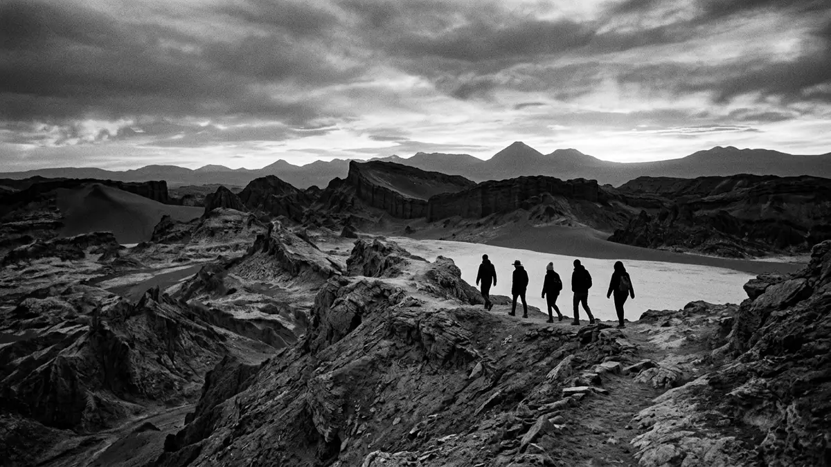
Valle de la Luna in northern Chile is a compact basin of salt, stone and sand west of San Pedro de Atacama, enclosed by the low ridges of the Cordillera de la Sal and shaped over geological time into a landscape that resembles the surface of the moon.Valle de la Luna (Chile) It forms one of the sectors of Reserva Nacional Los Flamencos, bringing a formally protected status to a stretch of desert where mineral crusts, dunes and rock outcrops sit closely together.Reserva Nacional Los Flamencos
A lunar landscape carved from salt and stone
Standing on the floor of Valle de la Luna, the first impression is of a depression in the Salt Mountain Range framed by ridges and slopes where layers of sediment have been exposed and weathered.depresión en la Cordillera del Sal The basin lies west of San Pedro de Atacama inside the Cordillera de la Sal, a low range pushed up where the wider Atacama Desert meets the Andes.part of the Cordillera de la Sal Across this depression, stone and sand formations have been carved by wind and occasional precipitation, creating crests, hollows and slopes that play with light as the sun moves across the desert sky.stone and sand formations
This landscape is not bare rock alone but a mixture of sedimentary material and mineral deposits inherited from an earlier basin filled with water that evaporated repeatedly, concentrating salts and clays. Geological descriptions of the wider Cordillera de la Sal refer to beds of halite, gypsum, clay and other minerals that were later folded and uplifted, forming ridges and transverse valleys.halite, gypsum and clay beds Within this raised terrain, Valle de la Luna occupies one of the most accessible and visually concentrated sections, where salt-rich ground, bare sedimentary rocks and sand dunes sit within a relatively compact area.compact landscape of salt, sand and stone
Salt crusts, dry lakes and the endorheic basin
One of the distinctive features of Valle de la Luna is the presence of salt in both the ground and the surrounding slopes, visible as pale crusts and coverings on the surface.salt ground There are dry lakes inside the valley where dissolved salts have crystallised into a white layer spread across the basin floor, a product of long cycles of water pooling and evaporating in a closed depression with no outlet to the sea.dry lakes with salt layer Geologists describe Valle de la Luna and neighbouring basins as endorheic, meaning that any water arriving remains within the system until it evaporates, concentrating the dissolved minerals in the process.endorheic basin
A wider view takes in the Cordillera de la Sal and the position of Valle de la Luna within Reserva Nacional Los Flamencos, a protected area divided into sectors that include salt flats, wetlands and archaeological sites.sector Valle de la Luna In this framework, the valley sector includes the Cordillera de la Sal itself and nearby sites, forming a landscape designation that acknowledges both its natural form and its status as a national monument.Landschaftsdenkmal The result for visitors is a stretch of terrain where ridges of limolite, gypsum, salt, clay and sand stand above a basin floor coated in mineral crusts, with the surrounding desert and distant volcanic peaks forming a wider backdrop.limolita, xeso e sal
Scale, altitude and the wider Atacama Desert setting
Valle de la Luna belongs to the Atacama Desert, a region often cited as one of the driest on Earth, and sits at an elevation of around 2,500 m (8,202 ft) above sea level, broadly comparable to the altitude of San Pedro de Atacama itself.2.500 m above sea level Descriptions of the valley refer to a depression roughly 500 m (1,640 ft) across, enclosed by ridges of similar height that define the immediate basin while leaving views towards the wider desert and the Andes beyond.small depression of salt ground In map terms, the valley lies to the west of San Pedro de Atacama, at the northern end of the Cordillera de la Sal, making it one of the closest desert landscapes to the town and a natural focus for excursions into the surrounding terrain.15 km west at northern end
The broader Cordillera de la Sal is described in geological writing as a raised structure formed from the former floor of a lake or inland sea associated with the Salar de Atacama, subsequently folded and uplifted through tectonic processes linked to the Andes and the Cordillera de Domeyko.lake or inland sea origin Within this raised structure, Valle de la Luna provides a cross-section of ridges, transverse valleys and exposed layers where limolite, gypsum, salt, clay and sand appear in close proximity, making the geological story legible on the surface in the form of sculpted outcrops and mineral crusts.series of transverse valleys and outcrops
Visiting Valle de la Luna: what travellers from Western Europe should know
- Valle de la Luna lies west of San Pedro de Atacama in northern Chile, within the Cordillera de la Sal and the Reserva Nacional Los Flamencos, and is reached by road from the town.
- The terrain in the valley consists of salt-crusted ground, sand dunes and rocky slopes, with ridges rising above the basin floor, so routes involve walking on uneven surfaces and negotiating short climbs.
- The wider setting is the high-altitude Atacama Desert, and the valley itself stands at roughly 2,500 m (8,202 ft), so visitors are exposed to strong sun and thin, dry air on open ground.
- Valle de la Luna forms one sector of Reserva Nacional Los Flamencos, whose administration is based near San Pedro de Atacama, and the protected status reflects its mineral-rich desert landscape.
- Chile’s official language is Spanish and the currency is the Chilean peso; entry requirements depend on your nationality, UK travellers can check the FCDO travel advice at gov.uk/foreign-travel-advice, Irish travellers the Department of Foreign Affairs at ireland.ie.
Searching for Valle de la Luna on social platforms
These links open searches for Valle de la Luna on each platform.Frequently asked questions about Valle de la Luna
Where is Valle de la Luna located?
Valle de la Luna lies west of San Pedro de Atacama in northern Chile, within the Cordillera de la Sal and forming part of the Reserva Nacional Los Flamencos.
What should visitors expect on a visit to Valle de la Luna?
Visitors encounter a compact desert basin of salt-crusted ground, sand dunes and rocky slopes, enclosed by ridges and shaped by long-term wind and water erosion.
What makes Valle de la Luna distinctive within the Atacama Desert?
The valley combines mineral-rich salt crusts, dry lakes and exposed sedimentary layers within a relatively small area, giving a concentrated view of the Cordillera de la Sal landscape.


