
Valle de Cocora’s wax palm landscapes above Salento
Published on 08/20/2026 at 16:57 | Editorial responsibility: Rafael Müller, Editor-in-Chief AD HOC NEWS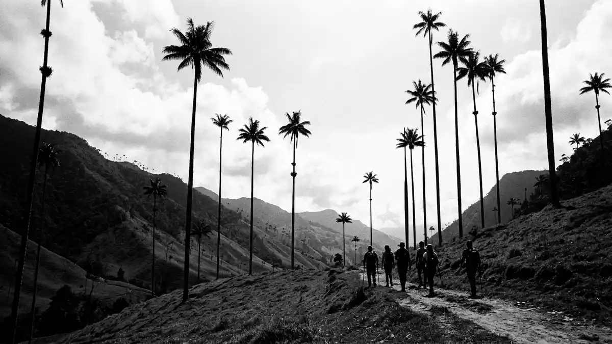
Valle de Cocora above Salento in Colombia is a high Andean valley where slender wax palms rise from steep green pastures and cloud forest along the upper Quindío River. Set in the Central Cordillera within the department of Quindío, the valley forms part of the broader Coffee Cultural Landscape of Colombia recognised by UNESCO, tying its dramatic scenery to a long history of mountain agriculture and coffee growing.
A high valley of wax palms and cloud forest
Valle de Cocora lies in the upper reaches of the Quindío River in the Central Cordillera of the Colombian Andes, at elevations between about 1,800 and 2,400 m (5,905–7,874 ft). The surrounding ridges frame a basin of sloping meadows and patches of cloud forest, with the river cutting through the valley floor and feeding damp grasslands where cattle graze and horses pick their way along muddy paths.upper reaches of the Quindío River
The most striking feature of Valle de Cocora is the Quindío wax palm, Ceroxylon quindiuense, Colombia’s national tree and the tallest palm species known. These palms can reach heights close to 60 m (197 ft), yet they keep remarkably slender trunks that rise straight from the grassy slopes before branching into feathery crowns high above eye level.Sixty-metre Quindío wax palms Dotted across the hillsides rather than forming dense forests, they create a landscape of isolated vertical lines against the layered backdrop of misty mountains.
Coffee country setting and protected status
Valle de Cocora sits within the municipality of Salento in Quindío, in an area known in Spanish as La Zona Cafetera, the Coffee Triangle where hillside farms cultivate coffee among other crops. The valley anchors a section of Los Nevados National Natural Park, a protected area of highland ecosystems that extends towards glaciated summits and volcanic peaks in the Central Cordillera.Los Nevados National Natural Park
The broader Coffee Cultural Landscape of Colombia was inscribed as a UNESCO World Heritage Site in 2011, recognising the combination of steep mountain terrain, traditional coffee farms and small towns that adapted agriculture to these elevations over more than a century.Coffee Cultural Landscape of Colombia Valle de Cocora sits inside this recognised landscape, providing one of its most visual scenes where agricultural pastures and grazing sit alongside conservation of native high-Andean forests and the emblematic wax palms.
Trails, pastures and Andean weather
The approach to Valle de Cocora runs north from Salento, following a road that climbs around 11 km (6.8 miles) into the mountains to reach trailheads and small clusters of buildings known locally as Cocora.approximately 24 km north-east of Armenia From these points, footpaths and horse tracks spread into the side valleys, crossing pasture gates, streams and short bridges as they gain height towards viewpoints where the palms stand most densely.
Many visitors follow looping trails that combine sections of wide meadow paths with narrower, uneven tracks through cloud forest, including stretches where simple bridges and wooden walkways span small rivers or muddy hollows.loop around 12 km long The terrain involves sustained gradients and a series of short climbs, and weather at these elevations can bring passing mist, low clouds and rain that quickly soften the ground, so sturdy footwear and preparation for changeable mountain conditions are important.
Visiting Valle de Cocora: what travellers from Western Europe should know
- Valle de Cocora lies north of Salento in the department of Quindío, reached by road along the valley of the Quindío River; local jeeps known as Willys commonly carry passengers from Salento’s main square towards the valley.
- The terrain combines sloping pastures and sections of cloud forest, with trails that include sustained gradients, muddy stretches and simple bridges, so walking in sturdy shoes and being ready for wet ground at elevation is necessary.
- In this part of the Colombian Andes, clouds and rain can move quickly through the valley, and temperatures at around 2,000 m (6,562 ft) feel cooler than in the lowland cities, so layers of clothing and weather protection are useful.
- Valle de Cocora forms part of Los Nevados National Natural Park and of Colombia’s Coffee Cultural Landscape, so a visit readily links with time in Salento and surrounding coffee farms that share this mountain setting.
- The official language is Spanish and the currency is the Colombian peso. Entry requirements depend on your nationality; UK travellers can check the FCDO travel advice at gov.uk/foreign-travel-advice, Irish travellers the Department of Foreign Affairs at ireland.ie.
Searching for Valle de Cocora on social platforms
These links open searches for Valle de Cocora on each platform.
Frequently asked questions about Valle de Cocora
Where is Valle de Cocora located?
Valle de Cocora is in the Central Cordillera of the Colombian Andes, within the municipality of Salento in the department of Quindío, north-east of Armenia.
What should visitors expect on a visit to Valle de Cocora?
Visitors encounter steep meadows, sections of cloud forest and long walking trails at elevations above 1,800 m (5,905 ft), with wax palms rising far above the grazing pastures.
What makes Valle de Cocora distinctive among Andean valleys?
The presence of exceptionally tall Quindío wax palms combined with its role in Colombia’s Coffee Cultural Landscape gives Valle de Cocora a recognisable mix of dramatic scenery and agricultural highlands.


