
Tonle Sap, the great shifting lake of Siem Reap
Published on 08/29/2026 at 19:04 | Editorial responsibility: Rafael Müller, Editor-in-Chief AD HOC NEWS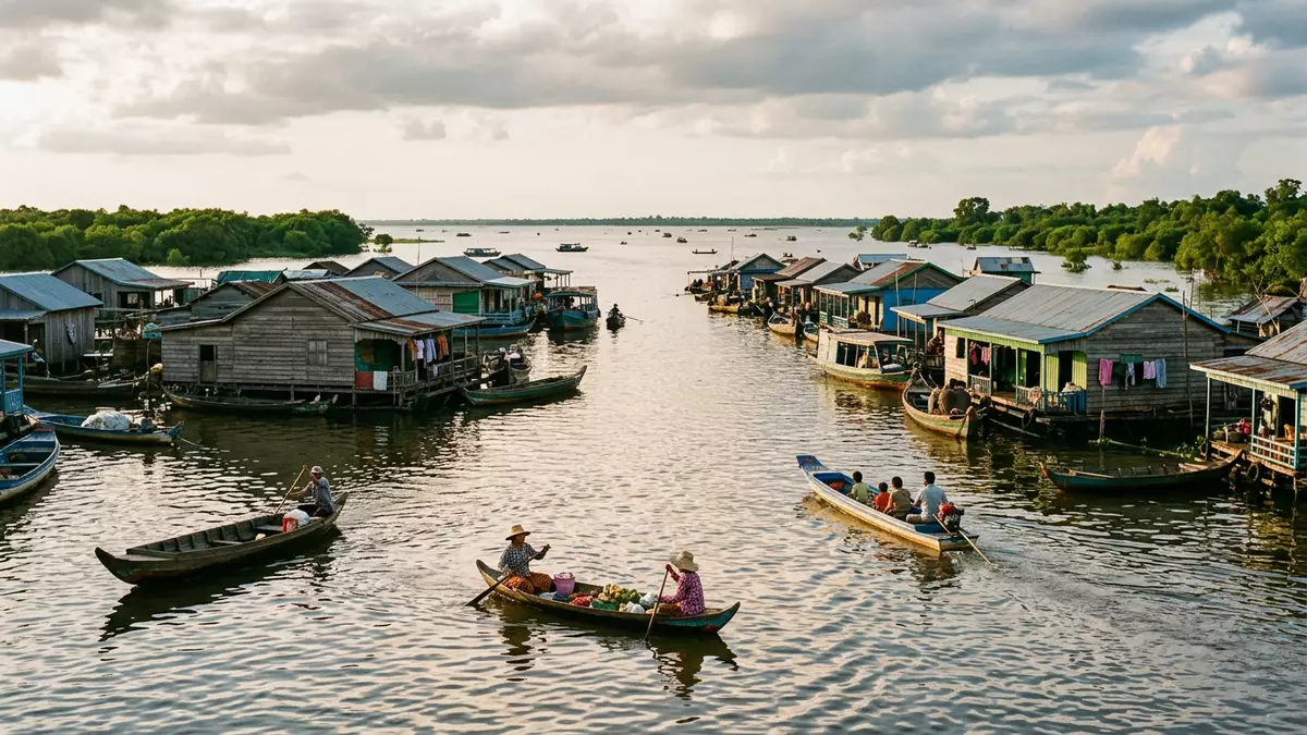
Tonle Sap is Cambodia’s “Great Lake”, a vast freshwater basin south of Siem Reap whose size and character change dramatically between the dry and wet monsoon seasons. It forms one of Southeast Asia’s most important inland waterscapes, supporting fishing communities in floating and stilted villages that adjust to the lake’s rise and fall.
A lake that reverses its river and changes its shape
Tonle Sap lies in central Cambodia and connects to the Mekong River via the Tonle Sap River, a short channel that behaves in an unusual way: during the wet monsoon months the flow into the lake reverses, driving Mekong water back into Tonle Sap and expanding its area severalfold.During the June-to-November monsoon the swollen Mekong pushes water upstream along the river, increasing the lake’s depth from a few metres to well over 9 m (30 ft) in places and turning shallow reed beds into a broad navigable water body.Its depth can reach around 9–14 m
This hydrological reversal also transforms Tonle Sap’s footprint on the Cambodian plain. In the dry months the lake covers a few thousand square kilometres; in the rains its flooded area extends across more than 10,000 km², spreading into seasonally inundated forest and rice land.Its width can increase from about 35 km to more than 100 km as the water rises. That expansion has been recognised internationally: Tonle Sap was designated as part of the UNESCO World Network of Biosphere Reserves in 1997, underlining its importance as an ecological and cultural landscape.UNESCO recognised Tonle Sap as a biosphere reserve in 1997
Floating and stilted villages along the northern shore
Along Tonle Sap’s northern margins, closest to Siem Reap, communities have built villages that rise and fall with the lake. Their houses stand on tall timber stilts or rest on floating platforms, clustered along river channels and open water. Several of these settlements – Chong Kneas, Kampong Phluk, Kampong Khleang and Mechrey – are reachable from Siem Reap by road and then by boat, each with its own structure and setting on the lake.Four main villages accessible from Siem Reap
Chong Kneas lies closest to the city, with houses, shops and a school built on pontoons that move with changing water levels.Chong Kneas is described as a true floating village on pontoons Kampong Phluk combines a high-stilted riverside settlement with access to flooded forest during high water, where trees stand in the lake and channels weave between their trunks.Kampong Phluk’s houses are built on tall stilts Further out, Kampong Khleang is a larger permanent settlement with rows of stilted homes lining waterways and open lake, and Mechrey sits on floating structures near bird-rich sections of the Tonle Sap Biosphere Reserve.Kampong Khleang and Mechrey are major lake communities
Fisheries, flooded forest and life on a changing water
The dramatic rise and fall of Tonle Sap underpins a productive freshwater ecosystem. As the lake expands, fish from the Mekong system spread into its waters and surrounding floodplain, feeding in inundated forest and grassland. The lake has long supported extensive carp breeding and harvesting, along with many other fish species that supply markets across Cambodia.The lake supports a large carp industry Seasonal fishing structures, floating platforms and small boats are common sights, tied directly to the annual rhythm of the flood.
Flooded forest around Tonle Sap plays a crucial role in this system. During high water, groves of trees and shrubs stand in the lake, creating sheltered habitat for fish and birds. Parts of this landscape form the core of the Tonle Sap Biosphere Reserve, including the Prek Toal area west of Siem Reap, which is a noted zone for birdlife within the wider lake environment.Scientific studies describe Tonle Sap’s flooded forest and seasonal expansion Life in the floating and stilted villages reflects these conditions: buildings, moorings and transport routes are all arranged to accommodate water that can rise by many metres between seasons.
Visiting Tonle Sap: what travellers from Western Europe should know
- Tonle Sap lies south of Siem Reap in central Cambodia, reached by road from the city and then by boat from landing points serving villages such as Chong Kneas and Kampong Phluk.
- The terrain around the lake includes unpaved tracks, jetties and riverbanks; access to boats may involve walking on uneven ground and using simple wooden steps.
- The wider Tonle Sap region lies within Cambodia, where the official language is Khmer and the currency is the Cambodian riel.
- Entry requirements depend on your nationality; UK travellers can check the FCDO travel advice at gov.uk/foreign-travel-advice, Irish travellers the Department of Foreign Affairs at ireland.ie.
Searching for Tonle Sap on social platforms
These links open searches for Tonle Sap on each platform.
Frequently asked questions about Tonle Sap
Where is Tonle Sap in relation to Siem Reap?
Tonle Sap lies to the south of Siem Reap in central Cambodia, linked to the city by roads that lead to boat landings on the lake’s northern edge.
What should travellers expect when visiting Tonle Sap?
Travellers encounter a shifting freshwater lake with boat access to floating and stilted villages, along with flooded forest and wide open water during the wet season.
What makes Tonle Sap distinctive among Southeast Asian lakes?
The lake’s connection to the Mekong River causes a seasonal reversal of flow, expanding its area by thousands of square kilometres and supporting extensive fisheries and floating communities.


