
Taman Nasional Komodo’s volcanic isles and dragons
Published on 09/14/2026 at 09:27 | Editorial responsibility: Rafael Müller, Editor-in-Chief AD HOC NEWS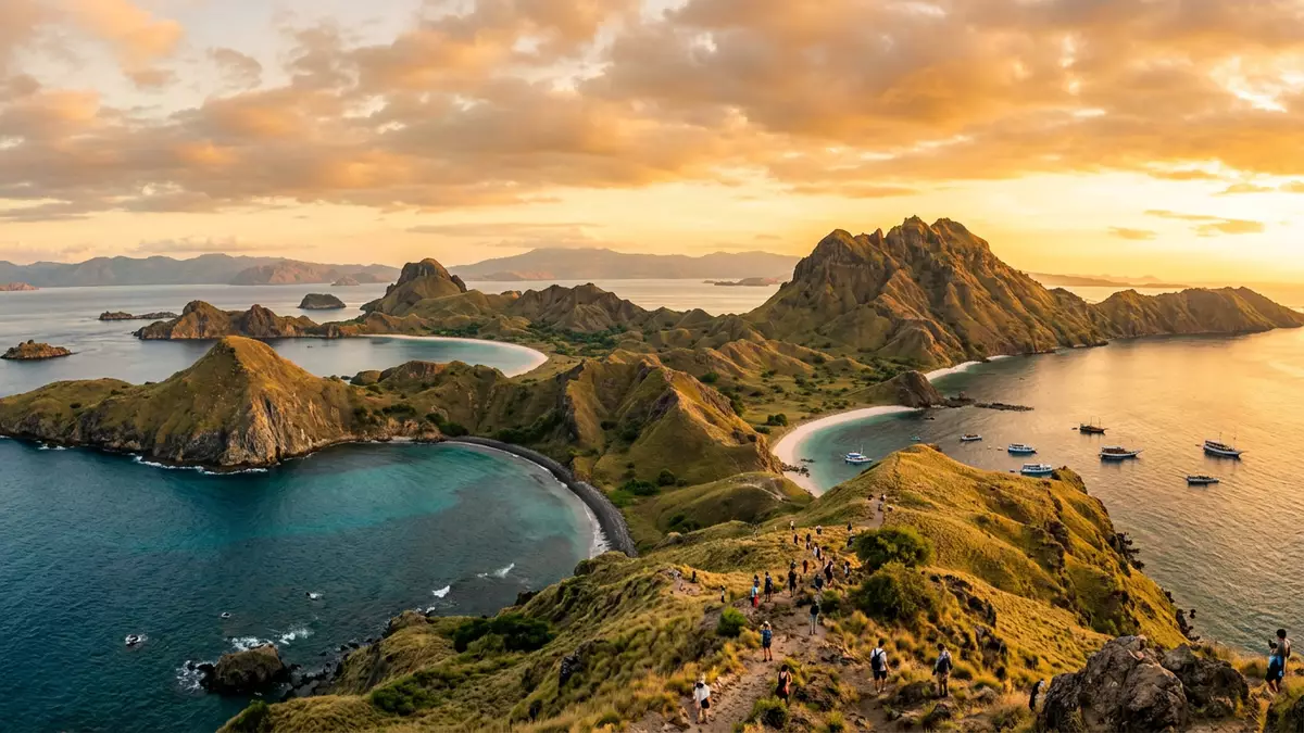
Taman Nasional Komodo, known internationally as Komodo National Park, spans volcanic islands and surrounding seas between the Indonesian islands of Flores and Sumbawa, with Labuan Bajo as the main gateway on the Flores side. Established as a national park in 1980 and inscribed on the UNESCO World Heritage List in 1991, it protects Komodo dragons alongside a wider mosaic of savanna hills and coral-rich marine habitat.
Volcanic islands between Flores and Sumbawa
The core of Taman Nasional Komodo consists of Komodo, Rinca and Padar, three larger islands of volcanic origin set among smaller islets in the Lesser Sunda Islands of Indonesia. The protected area lies in the Sape Strait between Flores to the east and Sumbawa to the west, forming part of East Nusa Tenggara province.three major islands These islands rise from clear tropical waters in steep ridges and valleys, with dry slopes supporting grassland and scattered trees.
The park’s boundary covers a mix of land and sea across more than 1,700 km² (around 670 sq mi), with terrestrial areas amounting to several hundred square kilometres and the remainder given over to marine habitat.? 1,733 km² protected area Within this space, the coastlines vary from sheltered bays to headlands where slopes drop towards fringing reefs. Away from the shore, hilltops give views across straits dotted with further islands.
Komodo dragons and terrestrial landscapes
Taman Nasional Komodo was founded in 1980 by the Government of Indonesia with the principal aim of conserving the Komodo dragon, the world’s largest living lizard.established in 1980 These reptiles, known scientifically as Varanus komodoensis, occur naturally on islands within the park and nearby areas and form a defining element of the terrestrial ecosystem. Their presence on Komodo, Rinca and other islands is closely tied to open savanna-like habitats, where shrubs and grassland cover rolling terrain.
The land vegetation reflects the park’s position in the Wallacea biogeographical region, a transitional zone between Asian and Australasian flora and fauna.Wallacea biogeographical region Hills tend to be dry for much of the year, with hardy grasses and scattered woodland, while pockets of denser vegetation appear in valleys and near watercourses. Inland areas also support deer and other mammals, as well as birdlife characteristic of this climatic and geographic transition between larger neighbouring landmasses.
Marine environments and UNESCO status
Beyond the shorelines, Taman Nasional Komodo encompasses extensive marine areas with coral reefs, seagrass beds and deeper channels that together hold varied tropical marine life.rich marine environments with coral reefs The park forms part of broader marine eco-regions recognised for biodiversity, and its underwater habitats include reef formations that support reef fish, invertebrates and occasional larger animals such as marine mammals. The juxtaposition of dry, rugged islands and colourful coral slopes contributes to its scientific and scenic importance.
Komodo’s conservation significance has been recognised through several international designations. The islands and surrounding waters gained recognition as a UNESCO Biosphere Reserve in 1977, and Komodo National Park followed as a national park in 1980.founded in 1980 to protect the Komodo dragon In 1991, the park was inscribed on the UNESCO World Heritage List as site number 609 under natural criteria (vii) and (x), reflecting both its land and marine biodiversity and the striking volcanic island scenery.World Heritage Site No. 609
Visiting Taman Nasional Komodo: what travellers from Western Europe should know
- Taman Nasional Komodo lies between Flores and Sumbawa in Indonesia’s Lesser Sunda Islands, with access to the park area commonly organised from Labuan Bajo on Flores.
- Much of the terrain on Komodo, Rinca and neighbouring islands consists of steep hills and dry slopes, so excursions on land typically involve walking on uneven paths and climbing gradients.
- Boat travel is fundamental within the park, as marine zones and island landing points are linked by water rather than roads, and movements between viewpoints, bays and trekking areas use vessels.
- The official language is Indonesian and the currency is the Indonesian rupiah.
- Entry requirements depend on your nationality; UK travellers can check the FCDO travel advice at gov.uk/foreign-travel-advice, Irish travellers the Department of Foreign Affairs at ireland.ie.
Searching for Taman Nasional Komodo on social platforms
These links open searches for Taman Nasional Komodo on each platform.
Frequently asked questions about Taman Nasional Komodo
Where is Taman Nasional Komodo located?
Taman Nasional Komodo is situated in Indonesia’s Lesser Sunda Islands between Flores and Sumbawa, with Labuan Bajo on the island of Flores acting as a common access point.
What can visitors expect on a visit to the park?
Visitors encounter rugged volcanic islands, dry savanna hills and surrounding marine areas with coral reefs, reached by boat and explored on foot along tracks and viewpoints.
What makes Taman Nasional Komodo distinctive among national parks?
Its combination of Komodo dragons, transitional Wallacea terrestrial ecosystems and extensive protected marine habitats, all recognised through UNESCO World Heritage and Biosphere Reserve status, makes it distinctive.


