
Stanley Park: Vancouver’s forested peninsula between harbour and bay
Published on 09/14/2026 at 07:03 | Editorial responsibility: Rafael Müller, Editor-in-Chief AD HOC NEWS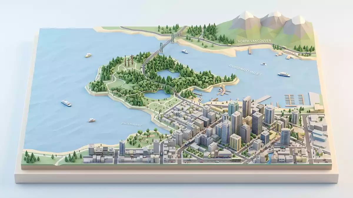
Stanley Park is a large urban park on the western tip of downtown Vancouver, a forested peninsula edged by seawall, harbour and bay. It opened to the public in 1888 and was named in honour of Lord Frederick Stanley, then Governor General of Canada, giving the city its first official park on the coast of British Columbia.
A nineteenth-century park on an older landscape
The peninsula that holds Stanley Park projects between Burrard Inlet to the north and English Bay to the south, framing Vancouver’s downtown on one side and the water routes towards the North Shore on the other.westernmost part of the downtown Vancouver peninsula Long before the park was established, this land formed part of the traditional territory of Coast Salish peoples, including the Musqueam, Squamish and Tsleil-Waututh Nations, whose presence on the peninsula is traced by archaeological findings spanning millennia.traditional territory of Coast Salish First Nations
In the nineteenth century the site was designated a government and military reserve before being leased to the City of Vancouver for park use, with the park formally opened on 27 September 1888.established as a public park in 1888 The naming honoured Lord Stanley, 16th Earl of Derby, whose dedication speech linked the park to people of all backgrounds.named after Canada’s Governor General Lord Frederick Stanley Later recognition as a National Historic Site of Canada underlined its role as a major urban park of its era, combining natural forest, designed landscapes and recreational amenities along the shoreline.
Forest, seawall and shoreline around the peninsula
Stanley Park retains extensive stands of coastal forest, with Douglas fir, western red cedar and hemlock rising above trails and clearings while roads loop through the trees towards viewpoints over Burrard Inlet and English Bay.forest trails, beaches and shoreline The park’s edge is traced by a continuous seawall path that follows the line of the peninsula from Coal Harbour around the outer headland and back towards the beaches at English Bay, separating the forested slopes from the tidal water.
Parts of the shoreline are rocky, with outcrops and views towards the Lions Gate Bridge and the North Shore mountains, while other sections flatten into sandy beaches facing the open bay. The seawall itself began as a series of stone retaining works started in 1917 to protect the park’s edge from erosion, gradually extended over decades to complete the loop around Stanley Park by 1980.stone retaining walls begun in 1917 and completed in 1980 Away from the outer shore, the interior includes lakes, gardens and open lawns where paths weave between wooded sections and more formal planted areas.
Cultural landmarks within the park
As well as trees and shoreline, Stanley Park holds a number of built and commemorative landmarks that reflect both Indigenous and later civic histories. At Brockton Point near the inner harbour, a grouping of totem poles carved by artists from several First Nations stands in a meadow close to the water, each pole carrying its own figures and stories while together forming one of the most recognisable cultural sites in the park.Brockton Point totem poles carved by artists from multiple Nations
Within the broader park area sits the Vancouver Aquarium, which developed as a major attraction in the post-war period and adds an indoor marine element to a visit focused otherwise on forests and water views.aquarium added during the post-war period Roads through the park connect downtown Vancouver to the Lions Gate Bridge, while commemorative sites and statues recall figures such as poet Pauline Johnson and events connected to British Columbia’s maritime and logging histories. These layers sit among contemporary paths, playgrounds and sports facilities, making the park both a recreational space and a place where traces of earlier periods are visible in its layout and markers.
Visiting Stanley Park: what travellers from Western Europe should know
- Stanley Park occupies the tip of the Vancouver peninsula west of the central business district and is reached over city streets from downtown or the West End neighbourhood.
- The terrain includes paved roads, long waterfront paths and forest trails, with some routes involving extended walks around the shoreline and gentle gradients rather than steep climbs.
- Beaches line parts of the park’s edge towards English Bay, while viewpoints over Burrard Inlet and the Lions Gate Bridge are accessible from roads and paths on the outer side of the peninsula.
- English is the official language and the currency is the Canadian dollar.
- Entry requirements depend on your nationality; UK travellers can check the FCDO travel advice at gov.uk/foreign-travel-advice, Irish travellers the Department of Foreign Affairs at ireland.ie.
Searching for Stanley Park on social platforms
These links open searches for Stanley Park on each platform.
Frequently asked questions about Stanley Park
Where is Stanley Park in Vancouver?
Stanley Park occupies a peninsula at the western edge of downtown Vancouver, bordered by Burrard Inlet on one side and English Bay on the other.
What can visitors expect during a visit?
Visitors encounter forested trails, the seawall along the shoreline, beaches, gardens, viewpoints over the harbour and bay, and cultural sites such as the Brockton Point totem poles.
What makes Stanley Park distinctive among urban parks?
The combination of nineteenth-century park design, extensive coastal forest, continuous seawall and prominent Indigenous and civic landmarks gives Stanley Park a character closely tied to both landscape and history.


