
Seoraksan Gungnip Gongwon and its granite ridges above Sokcho
Published on 09/02/2026 at 07:29 | Editorial responsibility: Rafael Müller, Editor-in-Chief AD HOC NEWS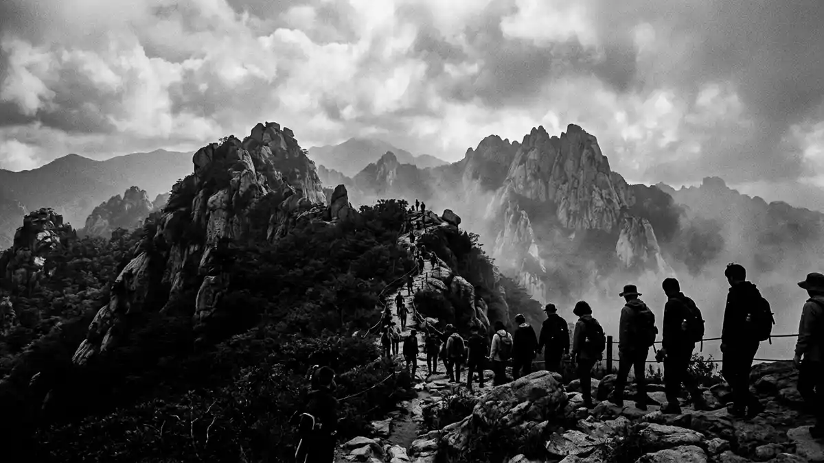
Seoraksan Gungnip Gongwon rises inland from Sokcho as a mountain park of granite ridges, forested valleys and high peaks. Its profile is shaped by Daecheongbong, which reaches 1,708 m (5,604 ft) and anchors the wider Seorak massif.
Granite ridges and forested valleys
The park lies in the Taebaek mountain range, where dissected granite and gneiss create sharp slopes and rocky spines. Mount Sorak lies on the east coast of the Korean Peninsula, and the land falls into a landscape of ridges, stream-cut valleys and steep mountain faces. Mount Sorak lies within a protected area that UNESCO nominated in 1982, and the same page records the peak at 1,708 m.
Seoraksan Gungnip Gongwon is the English rendering of the Korean name ???????, and the park covers a large mountainous tract in Gangwon Province. Its slopes hold coniferous forest, deciduous forest and high alpine vegetation, while the rock walls remain the most immediate visual feature. The park covers 398.24 km2 and extends across Sokcho-si, Yangyang-gun, Goseong-gun and Inje-gun.
From national park to biosphere reserve
Seoraksan Gungnip Gongwon became South Korea’s fifth national park in 1970, after earlier protection as a nature preservation area in 1965. The park also carries UNESCO biosphere reserve status from 1982, which places its mountain scenery within a wider conservation history. The park became a national park in 1970, and the same source records the 1965 preservation designation and the 1982 biosphere listing.
That layered status matches the park’s identity as both a mountain landscape and a protected ecological zone. Daecheongbong remains the highest point, and the surrounding ridges, cliffs and valleys give the park a strong sense of vertical relief rather than a single flattened panorama. The highest peak is Daecheongbong, and the park is described there as a granite-and-gneiss region with several summits above 1,200 m.
Sokcho and the park’s eastern edge
Sokcho sits close to the park’s eastern side, and Outer Seorak spreads towards the coastal city. The park’s dividing sections, including Inner Seorak and Outer Seorak, help describe a terrain that moves from inland valleys to the eastern mountain front. Outer Seorak lies across Sokcho-si, Yangyang-gun and Goseong-gun, while Inner Seorak is identified with Inje.
The same mountain system reaches across administrative borders, but the scenery remains continuous: exposed rock, wooded slopes and river-cut corridors. Travellers arriving from Sokcho encounter a park whose scale is visible in the shift from urban edge to mountain wall, and whose geology is visible in the bare granite above the trees. The park includes Sokchosi, Injegun and Yanyanggun, and that breadth helps explain why its terrain feels larger than a single valley.
Visiting Seoraksan Gungnip Gongwon: what travellers from Western Europe should know
- Seoraksan Gungnip Gongwon lies inland from Sokcho in Gangwon Province. The park is reached from the city by road, with the eastern sector facing the coast.
- The terrain is mountainous and steep, with granite, gneiss and high peaks. Daecheongbong rises to 1,708 m (5,604 ft).
- The park is spread across several administrative areas. Sokcho-si, Yangyang-gun, Goseong-gun and Inje-gun all form part of its footprint.
- Outer Seorak lies towards Sokcho, while Inner Seorak sits further inland. The park’s sections help describe its broad shape without turning it into a single viewpoint.
Searching for Seoraksan Gungnip Gongwon on social platforms
These links open searches for Seoraksan Gungnip Gongwon on each platform.
Frequently asked questions about Seoraksan Gungnip Gongwon
Where is Seoraksan Gungnip Gongwon?
It is a national park in Gangwon Province, inland from Sokcho in South Korea. The park stretches across several county and city areas in the Taebaek mountain range.
What does a visit involve?
The main impression is a mountain landscape of steep granite slopes, wooded valleys and high ridges. The ground rises sharply in places, and Daecheongbong stands above the rest of the park.
What makes it distinctive?
The combination of granite peaks, the Taebaek setting and the 1970 national park designation gives it a clear identity. Its 1982 UNESCO biosphere reserve status adds another formal layer to that profile.


