
Plitvicka jezera, Croatia’s cascading lake landscape
Published on 09/14/2026 at 07:32 | Editorial responsibility: Rafael Müller, Editor-in-Chief AD HOC NEWS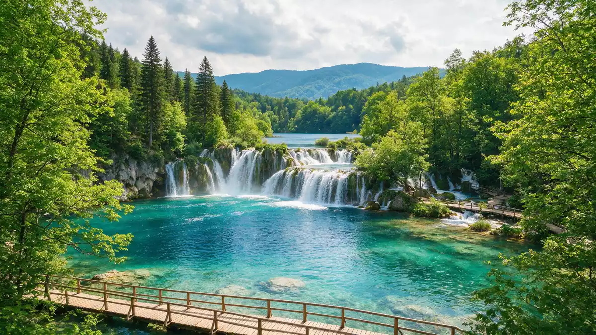
Plitvicka jezera, known in English as Plitvice Lakes National Park, is a karst landscape of stepped lakes and waterfalls in central Croatia’s Plitvice region. Between the Mala Kapela and Li?ka Plješivica mountain ranges, water has shaped limestone into natural dams, creating terraces of turquoise lakes linked by cascades and surrounded by dense forest.
The lake system and karst setting
The core of Plitvicka jezera is a connected system of lakes formed in a limestone and dolomite basin at the lower elevations of the Dinaric mountains. The protected national park covers almost 30,000 hectares, with the lake basin stretching along the valley where the Bijela rijeka and Crna rijeka join to form the Korana river.series of lakes in the valley The water has deposited travertine barriers over thousands of years, creating natural dams that impound clear, deep basins and produce vertical drops where waterfalls spill into the next level.
Within this basin, 16 named lakes stand in sequence, separated by vegetated ridges of tufa and linked by narrow channels, smaller pools and cascades.The lake system is comprised of 16 named The tiers run from higher reservoirs down to lower basins, giving the landscape a stepped form. Around the water, forest covers large areas of the park, with mixed woodland rising up the slopes and enclosing many of the lake perspectives between trees and rock.
From national park to World Heritage landscape
Plitvicka jezera was declared a national park in Yugoslavia in April 1949, making it the oldest national park in the Republic of Croatia.proclaimed national park 8 April 1949 The protected area has been expanded since that original designation, and today the park covers just under 300 square kilometres, administered mainly within Lika-Senj County with a smaller section in Karlovac County.covers an area just under 300 km^2^ The surrounding municipality of Plitvicka Jezera has its administrative seat in Korenica, and the park lies along the D1 main road between Zagreb and Split, near the border with Bosnia and Herzegovina.
In 1979, Plitvice Lakes National Park was inscribed on the UNESCO World Heritage List as a natural site, recognised for its outstanding natural beauty and its undisturbed travertine formation process.inscribed on the UNESCO World Heritage list in 1979 The original World Heritage area covered 19,462 hectares, and in 1997 the Croatian Parliament extended the national park, increasing the protected landscape to around 29,482 hectares and aligning the World Heritage boundaries with the wider park.area extended by the Croatian Parliament
Waterfalls, forests and wildlife
The character of Plitvicka jezera comes from the interaction between moving water, porous rock and vegetation. As water flows over limestone and chalk, it deposits travertine and builds barriers that redirect streams, generating countless waterfalls of varying heights and widths along the lake chain.waters flowing over the limestone and chalk Some falls spill in narrow streams, others in broad curtains, and many are fringed by moss and aquatic plants that contribute to the ongoing mineral deposition.
Beyond the water, extensive forest anchors the landscape, including mixed beech and fir stands, smaller broadleaf species and areas of conifer. These woodlands provide habitat for large mammals such as brown bear and wolf, as well as a range of bird species documented within the park.The forests in the park are home to bears Walking paths, boardwalks and viewpoints run close to the lakes and waterfalls and also rise above them, giving varied views across the basins, the enclosing cliffs and the forested slopes.
Visiting Plitvicka jezera: what travellers from Western Europe should know
- Plitvicka jezera lies in central Croatia, in the Lika region, along the D1 road between Slunj and Korenica, south of Karlovac and inland from the Adriatic coast.
- Within the park, many routes use wooden walkways close to the lake edges and uneven forest paths, with sections involving stairways and slopes that require steady footing.
- The terrain is mountainous karst, with altitudes high enough for winter snow and a marked contrast between the enclosed lake basins and the surrounding forested hills.
- The official language is Croatian and the currency is the Croatian kuna or its successor under national law.
Searching for Plitvicka jezera on social platforms
These links open searches for Plitvicka jezera on each platform.
Frequently asked questions about Plitvicka jezera
Where is Plitvicka jezera located?
Plitvicka jezera is in central Croatia’s Lika region, between the Mala Kapela and Li?ka Plješivica ranges, along the D1 road between Slunj and Korenica.
What should visitors expect on a visit?
Visitors encounter a chain of clear lakes, numerous waterfalls, forested slopes and karst rock, explored on marked paths and wooden walkways close to the water and through woodland.
What makes Plitvicka jezera distinctive?
Its distinctive character lies in the travertine-formed terraces of lakes and waterfalls within a protected karst landscape recognised as a UNESCO World Heritage natural site.


