
Pico de Orizaba, the snow-capped summit above Orizaba
Published on 09/18/2026 at 06:42 | Editorial responsibility: Rafael Müller, Editor-in-Chief AD HOC NEWS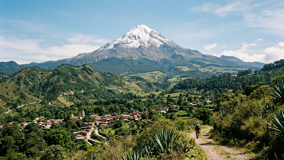
Pico de Orizaba, also known by its Nahuatl name Citlaltépetl, is a high stratovolcano rising above the city of Orizaba on the boundary between the Mexican states of Veracruz and Puebla. Its snow-capped summit reaches well over 5,500 m (around 18,000 ft) above sea level and has long been recognised as Mexico’s highest mountain and the highest volcano on the North American continent. The mountain belongs to the Trans-Mexican Volcanic Belt, a broad chain of volcanic terrain that crosses the country from the Pacific interior towards the Gulf of Mexico.
A volcanic cone above the Mexican plateau
Pico de Orizaba stands on the eastern margin of the Mexican highlands, where the interior plateau begins to drop towards the Gulf coastal plain. It rises on the Puebla–Veracruz boundary west of Orizaba, with its flanks spreading across both states and the summit forming a prominent landmark above the surrounding uplands.Puebla–Veracruz boundary The volcano’s overall form is that of a tall cone with steep upper slopes and broader aprons of volcanic deposits at lower levels, built from successive eruptions that laid down lava, ash and reworked volcanic sediment.
The mountain is part of the Trans-Mexican Volcanic Belt, a roughly east–west chain of volcanoes and volcanic ranges that includes peaks such as Cofre de Perote further north.Trans-Mexican Volcanic Belt Pico de Orizaba rises several thousand metres above its eastern base and forms the culmination of a volcanic alignment extending from the Mexican plateau towards the Gulf lowlands.towers the border between Puebla and Veracruz
Citlaltépetl: “Star Mountain” and glaciated summit
The Nahuatl name Citlaltépetl is often translated as “Star Mountain”, a reference linked to its height and the snow that covers its upper slopes. Above the volcanic cone the summit area carries glaciers, including the Jamapa Glacier on the northern flank, forming one of the few glaciated volcanic summits in Mexico.summit glaciers The high elevation gives the peak a symmetrical snow-clad profile that is visible from considerable distances across the plateau and coastal plain.
Pico de Orizaba rises to an elevation reported by many sources as 5,564 m (18,255 ft) or slightly higher, placing it ahead of all other Mexican mountains and ahead of other volcanic summits in North America such as Mount Rainier.Mexico's highest peak Its prominence relative to the surrounding terrain has been cited at about 4,922 m (16,148 ft), a measure that reflects how strongly the mountain rises above the landscape rather than only its absolute height.prominence 4,922 m
An active stratovolcano with a quiet crater
Geologically, Pico de Orizaba is a stratovolcano, also known as a composite volcano, built from alternating layers of lava flows, fragmented rock and volcanic ash. The main edifice formed in several stages beginning in the Pleistocene, and the present cone encloses a summit crater open to the sky.stratovolcano rising to 5,564 metres Historical eruptions have included moderate explosive activity and dacitic lava flows, and at least a handful of eruptions have been documented since the sixteenth century.
The most recent confirmed eruption took place in the nineteenth century, with 1846 recorded as the last year of observed eruptive activity.last confirmed eruption 1846 Since that time the volcano has been classified as dormant but still active by many catalogues, meaning that there is no ongoing eruption yet geological evidence indicates that further eruptions are possible.active volcano classification
Visiting Pico de Orizaba: what travellers from Western Europe should know
- Pico de Orizaba rises north-west of the city of Orizaba in eastern Mexico, between the states of Veracruz and Puebla, and is reached by mountain roads from surrounding towns.
- The ascent routes cross rocky volcanic slopes at altitude, with long sections on steep terrain and higher parts on glaciated surfaces where appropriate equipment and experience are necessary.
- The volcano lies in Mexico, where the official language is Spanish and the national currency is the Mexican peso.
- Entry requirements depend on your nationality; UK travellers can check the FCDO travel advice at gov.uk/foreign-travel-advice, Irish travellers the Department of Foreign Affairs at ireland.ie.
Searching for Pico de Orizaba on social platforms
These links open searches for Pico de Orizaba on each platform.
Frequently asked questions about Pico de Orizaba
Where is Pico de Orizaba located?
Pico de Orizaba stands on the boundary between the states of Veracruz and Puebla in eastern Mexico, north-west of the city of Orizaba.
What should visitors expect when approaching the mountain?
Visitors encounter a high volcanic cone rising above the Mexican plateau, with steep upper slopes, rocky terrain and, near the summit, permanent snow and glacier ice.
What makes Pico de Orizaba distinctive among North American mountains?
It is recognised as Mexico’s highest mountain and the highest volcano in North America, combining great elevation with a glaciated stratovolcanic summit above the plateau and Gulf lowlands.


