
Pico de Orizaba, Mexico’s snow?capped “Star Mountain”
Published on 08/27/2026 at 06:49 | Editorial responsibility: Rafael Müller, Editor-in-Chief AD HOC NEWS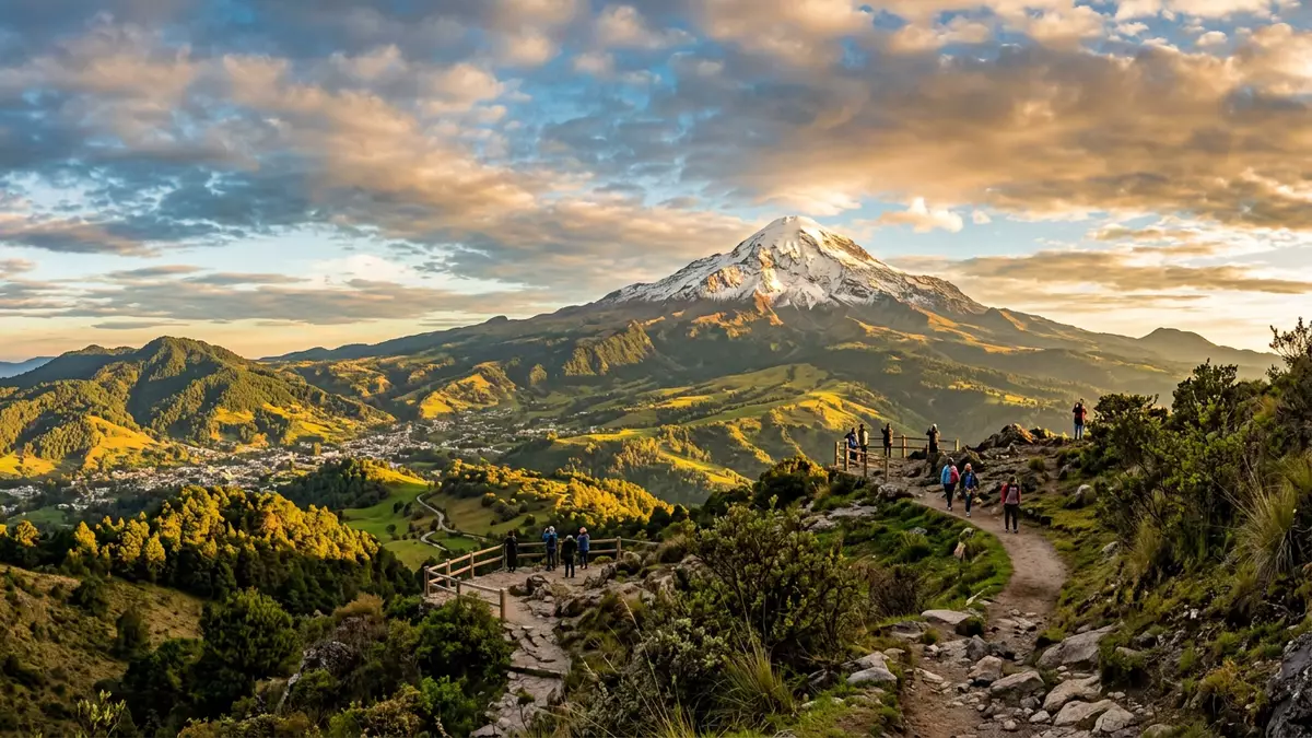
Pico de Orizaba, also known by its Nahuatl name Citlaltépetl or “Star Mountain”, is a snow?capped stratovolcano that dominates the highlands above Orizaba in Mexico. It is widely recorded as the country’s highest mountain and the highest volcano in North America, a solitary cone rising above the plains and ridges of the Trans?Mexican Volcanic Belt.
A solitary stratovolcano above central Mexico
Pico de Orizaba stands in south?central Mexico on the border between the states of Veracruz and Puebla, forming part of the eastern end of the Trans?Mexican Volcanic Belt that crosses the country.Trans?Mexican Volcanic Belt Its summit reaches about 5,636 m (18,491 ft) above sea level in many modern references, giving it a place alongside Denali in the United States and Mount Logan in Canada in listings of North America’s highest peaks.5,636 metres elevation The volcano rises from the southern edge of the Mexican Plateau, its cone visible from far across the surrounding countryside when skies are clear.southern edge of the Mexican Plateau
Geologically, Pico de Orizaba is a stratovolcano built up by successive eruptions that produced layers of lava and fragmented rock. It occupies and overlaps an older caldera structure, a reminder that the present cone developed over earlier volcanic activity in the region.stratovolcano within the Trans?Mexican volcanic belt The volcano is currently classed as dormant rather than extinct, with documented eruptive episodes in the seventeenth century and reference in several sources to an eruption in 1687.mid?Pleistocene stages of formation Standing at the high point of a national park, it forms the centrepiece of a protected landscape of alpine and subalpine ecosystems that extend down its flanks.national park surrounding the peak
Snow, ice and the “Star Mountain” name
The Nahuatl name Citlaltépetl combines “citlalin”, meaning star, with “tep?tl”, meaning mountain, a poetic description that has led to its common translation as “Star Mountain”.Nahuatl name Citlaltépetl High above Orizaba and the neighbouring settlements, the upper slopes carry permanent snow and ice in many years, and the summit cone retains a thin white covering or a more extensive glacier depending on the season and long?term climate conditions.permanent snow and ice The contrast between the bright summit and the darker lower slopes is one of the most striking visual features of the mountain.
Descriptions of Pico de Orizaba in climbing and geological accounts highlight an upper glacier that begins near the high altitudes of the mountain and drapes the steep upper cone.glacier begins near 4,900–5,000 m Near the summit there is a crater with steep inner walls and an irregular rim, a clear sign of its volcanic origin even when viewed from a distance through the typical veil of cloud or haze.crater at the summit Snowfields and ice patches trace curving lines down from the rim, interrupted by exposed rock where wind and sun have cleared the surface.
Routes, first ascents and human encounters
Pico de Orizaba has attracted climbers and surveyors for more than a century. Records of ascents mention mountaineers such as F. Maynard and William F. Raynolds who are credited with an ascent in 1848, placing the mountain among the earlier high?altitude objectives in Mexico to be climbed by organised expeditions.first ascent in 1848 Later accounts describe surveys and climbs that refined the altitude measurements, with figures around 5,700 m appearing in older reports before more recent sources converged on the commonly cited value of 5,636 m.historic altitude measurements
Modern mountaineering descriptions mention routes on the north and south faces of Pico de Orizaba, reached from settlements on either side of the volcano.popular routes include the North Face Trails and rough tracks lead to high?level refuges, above which climbers step onto the glacier and follow lines across snow and ice towards the rim of the crater. On the lower slopes, paths cross volcanic rock and high?altitude vegetation, while views open out towards the plains of Veracruz and the ridges of Puebla. Although the setting is dramatic, the ascent demands careful attention to altitude and weather, as the terrain involves steep gradients, exposed sections and compacted snow or ice.
Landscape and approach from Orizaba
The wider protected area around Pico de Orizaba is designated as a national park that covers almost 19,750 hectares, extending across both Veracruz and Puebla.Pico de Orizaba National Park Within this landscape, travellers encounter forested lower hills, open high pastures and rocky volcanic slopes. Streams descend from the snowfields, and the boundary between tree cover and alpine vegetation marks the shift into thinner air and more exposed terrain. The mountain sits north of the city of Orizaba in Veracruz, and views from the urban area and surrounding roads often frame the snow?capped cone above the everyday scene.
Approach routes from Orizaba and other towns in the region rely on road access into the foothills, where smaller settlements serve as starting points for excursions into the national park or for organised climbs of the volcano.approach via central Mexico As altitude increases, the access tracks become rougher, and high?clearance vehicles are common on the upper approach roads described in mountaineering guides. For visitors who remain at lower elevations, viewpoints on the surrounding hills offer vistas of the cone, with the snow and ice forming a bright triangle above the patchwork of fields and settlements in the valleys.
Visiting Pico de Orizaba: what travellers from Western Europe should know
- Pico de Orizaba rises north of the city of Orizaba in Veracruz, with road approaches leading from regional centres in Veracruz and Puebla into the national park.
- The terrain around the volcano includes steep volcanic slopes, high?altitude paths and sections of snow and ice on the upper cone, demanding sure footing and readiness for thin air.
- The wider area forms a protected national park in Mexico where Spanish is the official language and the currency is the Mexican peso.
- Entry requirements depend on your nationality; UK travellers can check the FCDO travel advice at gov.uk/foreign-travel-advice, Irish travellers the Department of Foreign Affairs at ireland.ie.
Searching for Pico de Orizaba on social platforms
These links open searches for Pico de Orizaba on each platform.
Frequently asked questions about Pico de Orizaba
Where is Pico de Orizaba located?
Pico de Orizaba stands on the border between Veracruz and Puebla in south?central Mexico, north of the city of Orizaba and within a national park.
What should visitors expect on a visit?
Visitors encounter a high?altitude volcanic landscape with forested lower slopes, open alpine terrain and a prominent snow?capped cone rising above the surrounding plains.
What makes Pico de Orizaba distinctive?
Pico de Orizaba is recorded as Mexico’s highest mountain and North America’s highest volcano, combining a solitary stratovolcano form with permanent snow and ice near its summit.


