
Pico de Orizaba, Mexico’s snow-capped giant above Orizaba
Published on 08/28/2026 at 08:03 | Editorial responsibility: Rafael Müller, Editor-in-Chief AD HOC NEWS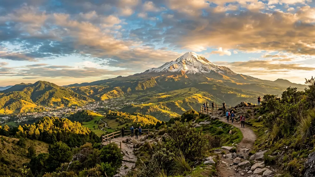
Pico de Orizaba, known in Nahuatl as Citlaltépetl, rises as a snow-capped stratovolcano above the Mexican city of Orizaba and the surrounding highlands. Its cone-shaped bulk links the elevated interior of Mexico with the lowlands that slope towards the Gulf of Mexico, giving travellers a clear sense of how mountain and plain meet.
A snow and ice giant of central Mexico
Pico de Orizaba is a stratovolcano on the boundary between the states of Veracruz and Puebla in central Mexico, standing within the east–west chain of the Trans-Mexican Volcanic Belt.stratovolcano on the boundary The mountain rises well above 5,500 m (18,000 ft) above sea level, making it the highest peak in Mexico and the highest volcano in North America.highest peak in Mexico From the plains to the east the cone stands in clear relief, its upper slopes covered in permanent snow and ice.
The Nahuatl name Citlaltépetl is usually translated as “Star Mountain”, a reference to the snow-bright summit that stands out above the darker lower slopes.“Star Mountain” Glaciers linger near the top, including the Jamapa Glacier on the northern side, and help to give the mountain its bright cap.Jamapa Glacier on the northern side The contrast between the white summit and the lower volcanic aprons of darker lava and ash is visible from far across the plateau.
Volcanic cone above Orizaba and the Gulf lowlands
The mountain stands west of the city of Orizaba in Veracruz, rising where the Mexican Plateau gives way to the coastal lowlands of the Gulf of Mexico.west of the city of Orizaba To its south, the lesser peak of Sierra Negra shares the skyline, underlining how this part of Mexico is shaped by a chain of volcanic summits.Sierra Negra shares the skyline The volcanic cone rises high above its base, giving the mountain a marked topographic prominence that makes it an unmistakable landmark from many directions.
The upper slopes are steep and cut by old lava flows, while lower down broad aprons of volcanic material spread out towards the surrounding countryside.broad aprons of volcanic material Near the summit lies a crater, with inner walls dropping sharply to the floor, reminding visitors that this bright mountain is also a volcanic structure shaped by past eruptions.crater with inner walls From vantage points on the flanks, the view runs across the plateau towards Puebla in one direction and down to the Gulf plains in the other.
Dormant volcano with a long climbing history
Pico de Orizaba is classified as a dormant but not extinct volcano, with documented eruptions into the nineteenth century and a long history of activity before that.dormant but not extinct volcano Historical records list eruptions in the sixteenth and seventeenth centuries, and a further event in 1846 marks the last confirmed eruption.eruptions in the sixteenth and seventeenth centuries The volcano belongs to the Trans-Mexican Volcanic Belt, a chain that includes other well-known Mexican peaks such as Popocatépetl and Iztaccíhuatl.Trans-Mexican Volcanic Belt
European and North American climbers reached the summit in the nineteenth century, including an ascent recorded in 1838, and organised mountaineering routes developed in the decades that followed.ascent recorded in 1838 In the twentieth century the mountain became an established objective for high-altitude climbers seeking a glaciated summit outside the Andes, combining a high elevation with access from central Mexican cities.established objective for high-altitude climbers The mixture of volcanic rock, snow and ice, together with the altitude, means that ascent routes demand preparation and respect.
Visiting Pico de Orizaba: what travellers from Western Europe should know
- Pico de Orizaba rises between the Mexican states of Veracruz and Puebla, west of the port city of Veracruz and north-east of Puebla city, and is reached by road from towns such as Orizaba and Tlachichuca.
- The mountain’s upper slopes lie at high altitude and involve rugged volcanic terrain, with steep gradients and sections of snow and ice near the summit.
- The peak and its surroundings form a national park recognised as Parque Nacional Pico de Orizaba, and the wider region includes other volcanic summits such as Sierra Negra.
- The official language is Spanish and the currency is the Mexican peso.
- Entry requirements depend on your nationality; UK travellers can check the FCDO travel advice at gov.uk/foreign-travel-advice, Irish travellers the Department of Foreign Affairs at ireland.ie.
Searching for Pico de Orizaba on social platforms
These links open searches for Pico de Orizaba on each platform.
Frequently asked questions about Pico de Orizaba
Where is Pico de Orizaba located?
The mountain stands on the boundary between Veracruz and Puebla in central Mexico, west of the city of Orizaba and inland from the Gulf of Mexico.
What should visitors expect when approaching the mountain?
Approaching Pico de Orizaba means travelling from Mexican towns into higher country, where roads climb towards volcanic slopes, thinner air and, near the summit, persistent snow and ice.
What makes Pico de Orizaba distinctive among Mexican mountains?
Pico de Orizaba combines the status of Mexico’s highest peak with a bright, glaciated summit cone, standing as North America’s highest volcano and a prominent landmark above Orizaba.


