
Parque nacional de Timanfaya and the frozen lava seas of Lanzarote
Published on 09/18/2026 at 19:03 | Editorial responsibility: Rafael Müller, Editor-in-Chief AD HOC NEWS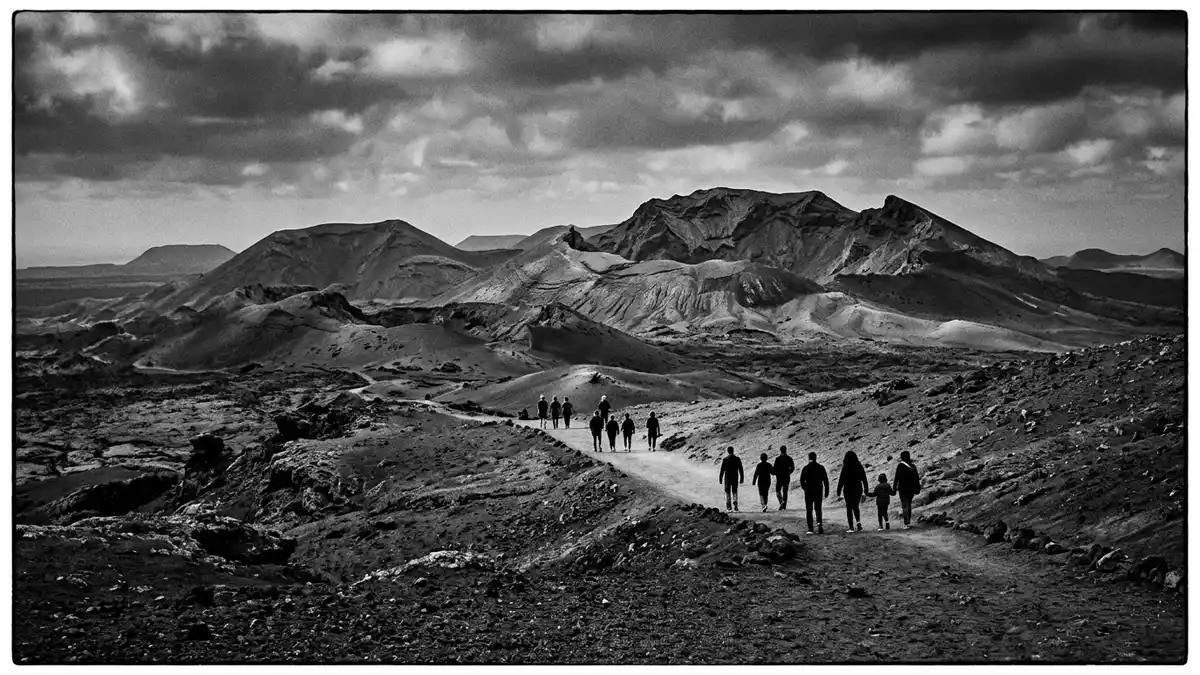
Parque nacional de Timanfaya on Lanzarote is a national park defined by vast lava fields, dark volcanic cones and a landscape shaped by eighteenth?century eruptions. Standing in this part of Spain’s Canary Islands means looking across terrain where molten rock once advanced over farmland and coastal villages, leaving a frozen sea of basalt in its wake.
Volcanic origins: an eighteenth?century lava sea
Parque nacional de Timanfaya lies in the centre?west of Lanzarote, between the municipalities of Yaiza and Tinajo, on an island formed by volcanic activity in the Atlantic Ocean. The national park status was declared in 1974, recognising a landscape where geology dominates almost every view.Declared park in 1974 The park forms part of the wider biosphere reserve that covers the island, placing its lava fields within a framework of conservation for both nature and traditional settlement.Biosphere reserve context
The present landscape of Timanfaya is the result of a cycle of eruptions that began on Lanzarote in 1730 and continued for several years, followed by further activity in the nineteenth century. During those eighteenth?century eruptions, numerous cinder cones and craters formed across the western part of the island, while fast?moving basaltic lava spread outwards to create extensive fields of solidified rock.Eruptions between 1730 and 1736 Parts of Lanzarote gained new land along the coast as lava reached the sea and hardened, reshaping bays and cliffs in the process.Coastal extensions by lava
A national park defined by geology
Timanfaya is described within Spain’s national park system as an eminently geological park, emphasising its role as a showcase for volcanic landforms rather than forests, rivers or lakes. Its surface is dominated by lava and ash, with very little soil and almost no permanent surface water, creating an environment where shapes of cooled magma, slag and scoria are visible at every turn.Geological character of the park Visitors encounter an array of lava types, from smoother basalt flows to rough, broken ?a?? surfaces, arranged in overlapping layers that record separate eruptive phases.Basaltic composition of the lava
Within the park stands the area known as Montañas del Fuego, where numerous craters mark the core of the eighteenth?century eruptions. Here, ground that once opened along fissures now holds stepped cones and collapsed centres, with colours ranging from deep black and rust red to ochre and grey. The absence of large trees and rivers leaves these landforms visually exposed, so that layers in the rock and the edges of individual flows can be traced across the hillsides without obstruction.Montañas del Fuego area
Heat beneath the surface and life on the lava
Although Timanfaya’s last lava?producing eruption took place in the nineteenth century, the volcanic system beneath the park remains active in the sense of retaining intense geothermal heat. Measurements within the ground show very high temperatures at shallow depths, evidence that magma still lies close beneath the cooled surface.Dormant but geothermal activity This heat is part of the park’s identity, illustrating that the lava fields are not merely historical formations but part of a living volcanic environment.
Despite the apparently barren character of the lava seas, Timanfaya holds species of flora and fauna adapted to limited water and thin, mineral?rich substrates. Lichens and hardy plants establish themselves on rough rock surfaces, beginning slow processes of weathering and soil formation. In more sheltered hollows, these pioneer species form small patches of colour on otherwise dark expanses, showing how life takes hold even where conditions appear severely constrained.Endemic species adapted to conditions
Visiting Parque nacional de Timanfaya: what travellers from Western Europe should know
- Parque nacional de Timanfaya lies in the centre?west of Lanzarote in Spain, between Yaiza and Tinajo, and is reached by road along the LZ?67 that crosses the lava fields.
- The terrain within the protected area consists of solidified lava, ash slopes and craters, so designated visitor routes follow paved or prepared surfaces rather than allowing free wandering across the rock.
- Approaches to viewpoints in the Montañas del Fuego area include sections with a noticeable gradient and stretches over uneven volcanic ground, which can feel exposed under the island’s strong sun.
- English is not an official language in Spain and the currency is the euro.
- Entry requirements depend on your nationality; UK travellers can check the FCDO travel advice at gov.uk/foreign-travel-advice, Irish travellers the Department of Foreign Affairs at ireland.ie.
Searching for Parque nacional de Timanfaya on social platforms
These links open searches for Parque nacional de Timanfaya on each platform.Frequently asked questions about Parque nacional de Timanfaya
Where is Parque nacional de Timanfaya located?
Parque nacional de Timanfaya is located in the centre?western part of Lanzarote, one of Spain’s Canary Islands, between the municipalities of Yaiza and Tinajo.
What should visitors expect when entering the park?
Visitors encounter extensive lava fields, cinder cones and craters formed during eighteenth?century eruptions, with designated routes that cross solidified basalt and ash rather than forest or river landscapes.
What makes Parque nacional de Timanfaya distinctive among Spain’s national parks?
Timanfaya stands out for its focus on volcanic geology, with an environment dominated by lava and ash and recognised as a national park since 1974 within the wider Lanzarote biosphere reserve.


