
Parque Nacional Cotopaxi and the high plains around an Andean giant
Published on 08/21/2026 at 07:01 | Editorial responsibility: Rafael Müller, Editor-in-Chief AD HOC NEWS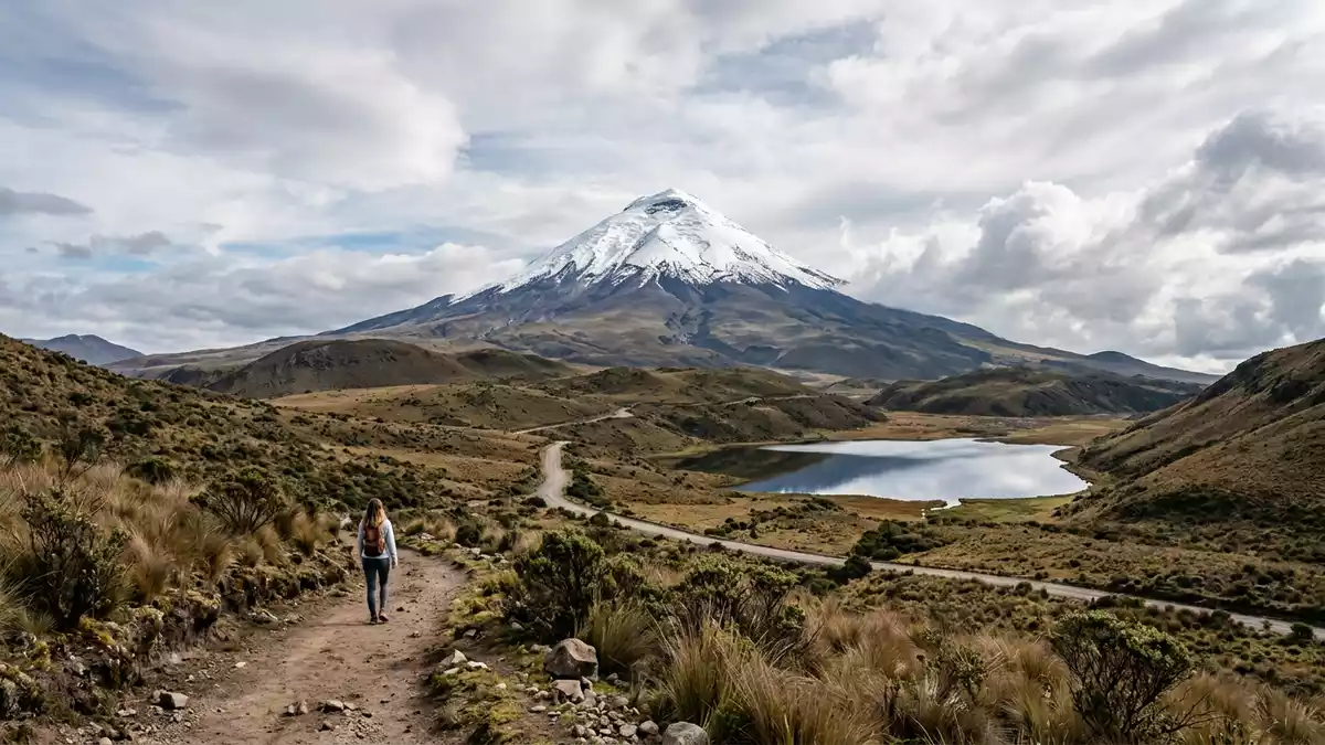
Parque Nacional Cotopaxi in the central highlands of Ecuador spreads across the Andean plateau east of Latacunga, wrapping around the volcanic cone of Cotopaxi. Created as a national park in 1975, it protects a sweep of páramo grassland, lava fields and lagoons beneath one of South America’s best known active volcanoes.
Cotopaxi volcano above the plateau
The park takes its name from Cotopaxi, an Andean stratovolcano whose summit reaches 5,897 m (19,347 ft) above sea level.Cotopaxi, an active stratovolcano The volcano rises from the high plateau of Cotopaxi Province, roughly south of Quito and north-east of Latacunga, its upper slopes usually covered in snow and ice.The park surrounds Cotopaxi in Cotopaxi Province
Cotopaxi’s cone dominates the skyline from within the park boundaries, standing above a broad pedestal of older lava flows and glacial deposits. On clear days the outline of neighbouring volcanoes, including Rumiñahui, appears along the horizon, making Parque Nacional Cotopaxi a concentrated panorama of Ecuador’s central Andes.
A protected Andean landscape since 1975
Parque Nacional Cotopaxi was established as a protected area on 11 August 1975 by an interministerial agreement that brought it into Ecuador’s national system of parks.The park was created on 11 August 1975 The protected area extends across parts of Cotopaxi, Pichincha and Napo provinces in the central Sierra region, with boundaries that follow ridgelines around the Cotopaxi and Rumiñahui massifs and reach towards the basin of the Pita River.The park spans three Andean provinces
The altitude range inside Parque Nacional Cotopaxi runs from roughly 3,400 m (11,155 ft) on the lower páramo up to the 5,897 m (19,347 ft) summit of Cotopaxi itself.The park’s altitude spans more than 2,000 metres Within this band lie grasslands, scattered Andean shrubs, patches of high-altitude forest in sheltered valleys and bare, ash-covered slopes on the upper reaches of the volcano. The protected status shelters wildlife characteristic of the Ecuadorian Andes, including camelids, ground-nesting birds and raptors circling on the wind above the plateau.
Lagoon, haciendas and Andean páramo
Beyond the volcano itself, Parque Nacional Cotopaxi is known for open páramo landscapes cut by streams and dotted with wetlands. One of the most accessible features is the Limpiopungo lagoon, a shallow body of water set in the plain beneath the slopes of Rumiñahui, where waterfowl gather along the shore and the volcanic backdrop reflects in the surface on calm days.Laguna de Limpiopungo lies inside the park
The lower parts of the park are bordered by historic haciendas, some of which stand near the northern entrance reached from Machachi on the Pan-American Highway. Inside the park, unpaved roads cross lava fields and grassland slopes, linking control points, picnic areas and viewpoints from which visitors see the contrasts between dark volcanic rock, pale grasses and Cotopaxi’s icecap.
Visiting Parque Nacional Cotopaxi: what travellers from Western Europe should know
- Parque Nacional Cotopaxi lies in central Ecuador in the Andes, between Quito and Latacunga, with access points signposted from the Pan-American Highway that links these cities.
- The terrain is high-altitude páramo, with vehicle tracks over rough ground and walking routes on uneven paths that can feel strenuous because of the elevation.
- The park spans parts of Cotopaxi, Pichincha and Napo provinces in the Ecuadorian Sierra. The official language is Spanish and the currency is the US dollar.
- Weather on the plateau can shift between strong sun and cold, wet conditions, and the wind across the open grassland is a constant factor on exposed routes.
- Entry requirements depend on your nationality; UK travellers can check the FCDO travel advice at gov.uk/foreign-travel-advice, Irish travellers the Department of Foreign Affairs at ireland.ie.
Searching for Parque Nacional Cotopaxi on social platforms
These links open searches for Parque Nacional Cotopaxi on each platform.
Frequently asked questions about Parque Nacional Cotopaxi
Where is Parque Nacional Cotopaxi in relation to Latacunga?
Parque Nacional Cotopaxi lies in Ecuador’s central Andes, spreading across Cotopaxi Province north-east of Latacunga and roughly south of Quito along the main highland corridor.
What should visitors expect from the landscape inside the park?
The park combines the snow-covered cone of Cotopaxi with high Andean grassland, wetlands such as the Limpiopungo lagoon and wide views over surrounding volcanoes and plateaus.
What makes Parque Nacional Cotopaxi distinctive among Ecuador’s protected areas?
Its character comes from the combination of a nearly symmetrical stratovolcano, a broad high-altitude plateau and a protected slice of central Andean páramo within reach of major cities.


