
Otaru Unga, the stone-lined canal at the heart of Otaru
Published on 09/17/2026 at 07:59 | Editorial responsibility: Rafael Müller, Editor-in-Chief AD HOC NEWS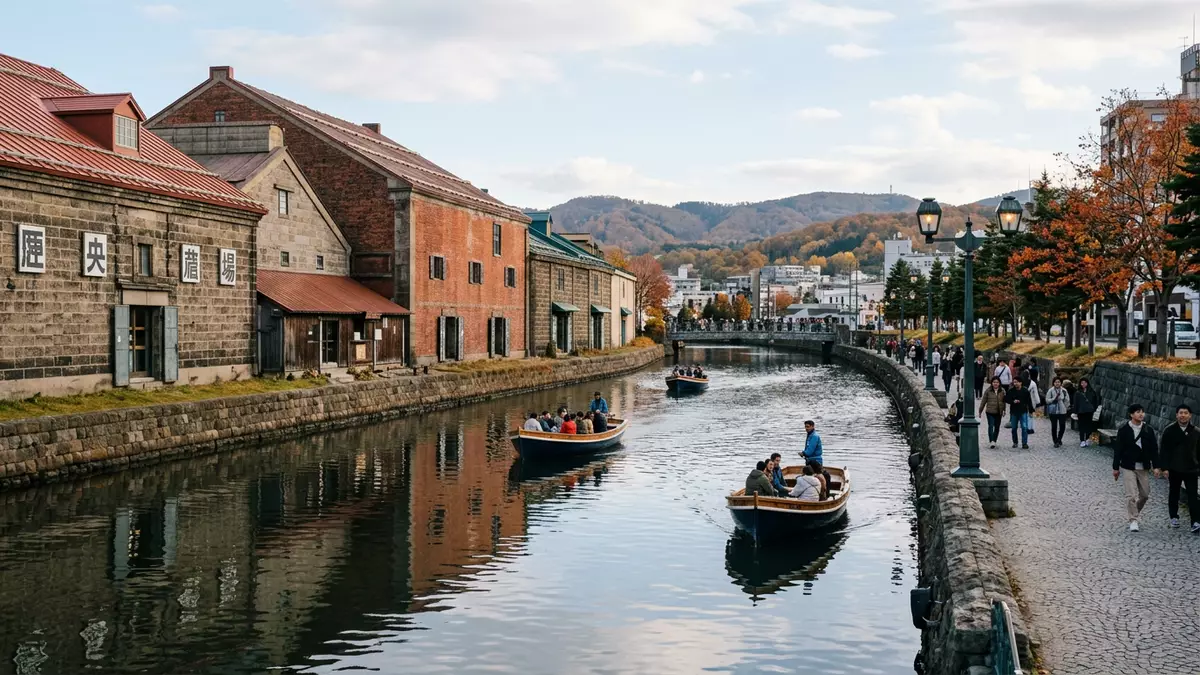
Otaru Unga in Otaru on Hokkaido’s Sea of Japan coast is the historic canal that keeps the city’s early twentieth-century port landscape legible as a stone-lined waterway flanked by warehouses and promenades. Completed in 1923 after years of land reclamation, it threads water between reclaimed harbour land and the older shore, forming a linear waterfront that still carries the outlines of a working cargo port.
A canal cut from a growing port
Otaru grew in the late nineteenth and early twentieth centuries as a key trading port for Hokkaido, linked to coalfields and fishing grounds by rail and shipping routes across northern Japan. Coal from inland mines reached the harbour via the Horonai Railway, opened in 1882 as Hokkaido’s first government-run railway, feeding the expanding wharves and warehouses that lined the bay.Horonai Railway opened in 1882 As trade increased, barges shuttled between ocean-going ships anchored offshore and the shoreline, but the crowded waterfront left little sheltered space for them to moor.
From 1914 to 1923, the harbour edge was reshaped through land reclamation that created a string of narrow artificial islands parallel to the original shoreline. The waterway left between the reclaimed land and the landward side became Otaru Unga, a canal at first around 40 m (131 ft) wide that offered protected mooring space for barges and small cargo boats.land reclaimed between 1914 and 1923 With ocean-going ships moored in the bay and smaller craft running along the canal, goods could move directly into the stone warehouses that stood on the reclaimed islands, turning the new waterway into a working axis for the port.
Stone warehouses and the north–south canal
Walking beside Otaru Unga today, the canal reads as a long, gently curving band of water edged with stone embankments and rows of robust warehouses built from masonry and brick. Many of these buildings formed the storage backbone of the port’s commercial district, lining the side of the canal that faces the reclaimed land and standing close to the water so cargo could move between barges and warehouse doors with minimal handling.warehouses along the canal Their thick walls and simple profiles give the waterfront a heavy, industrial character even where interiors have taken on new roles.
The canal itself has two distinct stretches that reflect its working past and its later reshaping. Along the section beside the harbour road, sometimes called the south canal, half of the channel was reclaimed in the 1980s, narrowing the waterway to about 20 m (66 ft) and creating space for a broad pedestrian route beside the stone edge.south canal narrowed and promenade built Further north, the canal retains its earlier width of around 40 m (131 ft), keeping more of the working proportions that once accommodated barges lining up along both banks. This north stretch remains edged by moored small boats, tying the preserved stone-fronted landscape back to the maritime life of the port.
From cargo route to waterfront promenade
By the late 1930s, new harbour wharves allowed larger cargo ships to dock directly, and freight handling shifted to modern piers and land-based transport. As Japan’s energy supply moved from coal to oil and trade patterns changed, Otaru’s role as a primary financial and shipping centre diminished, and Otaru Unga’s cargo function faded.new wharf built in 1937 In the decades that followed, plans emerged to fill the canal and demolish neighbouring warehouses to make way for further road construction, threatening to erase the physical trace of the port’s formative era.
Local residents organised to preserve the canal and its waterfront buildings, arguing for conservation rather than full reclamation. Their efforts led to a compromise in the 1980s in which part of the canal was narrowed for a road, while a continuous promenade was built along the remaining waterway and the stone warehouses were retained and adapted to new uses.citizens movement saved canal and warehouses Many warehouses now house museums, shops and restaurants, but their massing, materials and proximity to the canal keep the industrial waterfront readable, turning former cargo infrastructure into a linear public space where water, stone and city streets coexist.
Visiting Otaru Unga: what travellers from Western Europe should know
- Otaru Unga runs through the harbour district of Otaru on Hokkaido in Japan, close to streets such as Minatomachi and within walking distance of JR Otaru Station on the Hakodate Main Line.
- The main promenade beside the canal follows the stone embankment and includes long stretches of level paving, with side streets and bridges linking the waterfront to the surrounding city blocks.
- The canal sits in a low-lying harbour area, with city hills rising behind the warehouses; approaches from the station involve a downhill walk towards the waterfront and an equivalent uphill return.
- The official language is Japanese and the currency is the yen.
- Entry requirements depend on your nationality; UK travellers can check the FCDO travel advice at gov.uk/foreign-travel-advice, Irish travellers the Department of Foreign Affairs at ireland.ie.
Searching for Otaru Unga on social platforms
These links open searches for Otaru Unga on each platform.Frequently asked questions about Otaru Unga
Where is Otaru Unga located within Otaru?
Otaru Unga runs through the harbour district of Otaru on Hokkaido’s Sea of Japan coast, with its main stretch beside streets such as Minatomachi close to JR Otaru Station.
What can visitors expect when walking along the canal?
A walk along Otaru Unga follows a gently curving canal edged with stone embankments, adapted warehouses and a long promenade, with bridges and side streets linking the waterway to the surrounding city.
What makes Otaru Unga distinctive among Japanese port landscapes?
The canal preserves a continuous early twentieth-century waterfront where reclaimed harbour land, stone warehouses and the waterway itself remain side by side, turning former cargo infrastructure into an accessible public waterfront.


