
Murchison Falls National Park where the Nile explodes through rock
Published on 09/19/2026 at 14:14 | Editorial responsibility: Rafael Müller, Editor-in-Chief AD HOC NEWS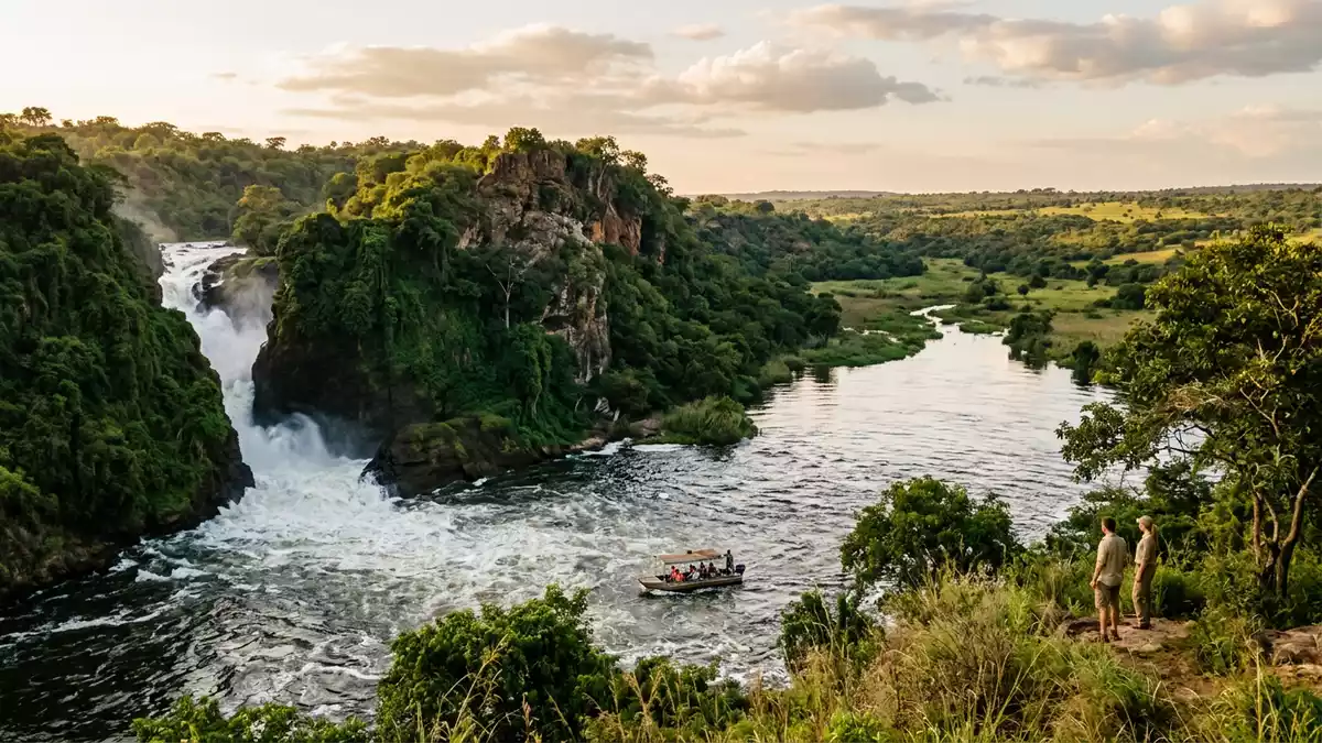
Murchison Falls National Park in north-western Uganda is built around a single dramatic moment in the course of the Victoria Nile, where the river is squeezed through rock and drops into a churning pool. Stretching across grassland, woodland and riverine forest in districts including Masindi, it forms the core of the wider Murchison Falls Conservation Area, a protected landscape that has been part of Uganda’s conservation story since it was designated a national park in 1952.
The Nile’s narrow gorge and the fall that names the park
The defining feature of Murchison Falls National Park is the waterfall that lends it its name, set on the lower Victoria Nile between Lake Kyoga and Lake Albert. At this point the river, wide and fast-moving in the approaches, is forced through a gorge that is only about 7–8 m (23–26 ft) across before plunging in a single drop of roughly 40–45 m (131–148 ft) into a pool often described as the Devil’s Cauldron.The cataract on the Victoria Nile From the viewpoints near the gorge, the sightlines take in the confined channel, the walls of weathered rock and the spray that rises from the base of the fall.
The waterfall has long carried more than one name. English explorer Samuel White Baker visited it in the nineteenth century and applied the name “Murchison Falls” after the geologist Roderick Murchison.The naming of the falls In Uganda it is also known as Kabalega Falls, a reminder of local history and of the Bunyoro kingdom whose former territories overlap with the park.
Uganda’s largest national park along the Albertine Rift
Beyond the gorge, Murchison Falls National Park extends over an area of around 3,840–3,893 km² (1,483–1,503 sq mi), making it the largest of Uganda’s national parks.The park’s size and status It occupies rolling grassland east of Lake Albert and lies at the northern end of the Albertine Rift Valley, where an escarpment known as the Bunyoro escarpment descends into palm-dotted plains. The protected area dates back to 1926, when wildlife reserves in Bunyoro and Gulu were gazetted; these lands were later upgraded to form one of Uganda’s first national parks in 1952.From reserve to national park
Administratively, the park straddles several districts including Masindi, Buliisa, Nwoya and Kiryandongo, and together with the Bugungu and Karuma Falls Wildlife Reserves it forms the wider Murchison Falls Conservation Area. Within this wider unit, elevations range roughly between 650 and 1,290 m (2,133–4,232 ft) above sea level, and habitats shift from open savanna with scattered trees to riverine forest and wetland fringing the Nile.The conservation area and its elevation
The Victoria Nile as the organising line of the landscape
The Victoria Nile effectively organises the geography of Murchison Falls National Park, flowing from east to west across the park for more than 100 km (62 mi) on its way towards Lake Albert.The river crossing the park In its passage it alternates between long reaches of broad water, stretches of rapids and the narrowed section at Murchison Falls itself. Boat trips on sections of the river reveal banks lined with riverine woodland, exposed sandbars and cliffs of rust-red rock rising above the channel.
The park’s layout reflects this central river. Road networks, boat launch points and viewpoints are arranged around crossings of the Nile and approaches to the falls, with northern and southern sectors connected by bridges and ferries. Much of the wildlife viewing focuses on areas close to the river, where animals move between grassland and water and where hippos and crocodiles are conspicuous in the channel.
Visiting Murchison Falls National Park: what travellers from Western Europe should know
- Murchison Falls National Park lies in north-western Uganda, with Masindi acting as a key gateway town on the southern side of the protected area. Access routes by road link Masindi and other centres to park gates on both sides of the Nile, including approaches near the river that leads towards viewpoints above the falls.
- The terrain combines open savanna tracks with sections of woodland and riverbank that can be steep near the gorge. Around the falls themselves, paths and viewing areas involve gradients and uneven rock underfoot, and some vantage points are reached by short climbs.
- The Victoria Nile runs through the park from east to west, and several viewpoints and boat launch points sit close to the water. Travellers encounter exposed conditions on the grassland and contrasting shade in patches of riverine forest along the banks.
- The official language is English and the currency is the Ugandan shilling.
- Entry requirements depend on your nationality; UK travellers can check the FCDO travel advice at gov.uk/foreign-travel-advice, Irish travellers the Department of Foreign Affairs at ireland.ie.
Searching for Murchison Falls National Park on social platforms
These links open searches for Murchison Falls National Park on each platform.
Frequently asked questions about Murchison Falls National Park
Where is Murchison Falls National Park?
Murchison Falls National Park is in north-western Uganda, east of Lake Albert, in districts that include Masindi, with the Victoria Nile running across it.
What can visitors expect on a visit?
Visitors encounter savanna and woodland landscapes centred on the Victoria Nile, with viewpoints over Murchison Falls and access to river sections where wildlife concentrates.
What makes Murchison Falls National Park distinctive?
The park is notable for combining Uganda’s largest national park with a dramatic section of the Nile, where the river is forced through a narrow gorge to form Murchison Falls.


