
Miraflores, Lima’s clifftop district above the Pacific
Published on 08/26/2026 at 22:37 | Editorial responsibility: Rafael Müller, Editor-in-Chief AD HOC NEWS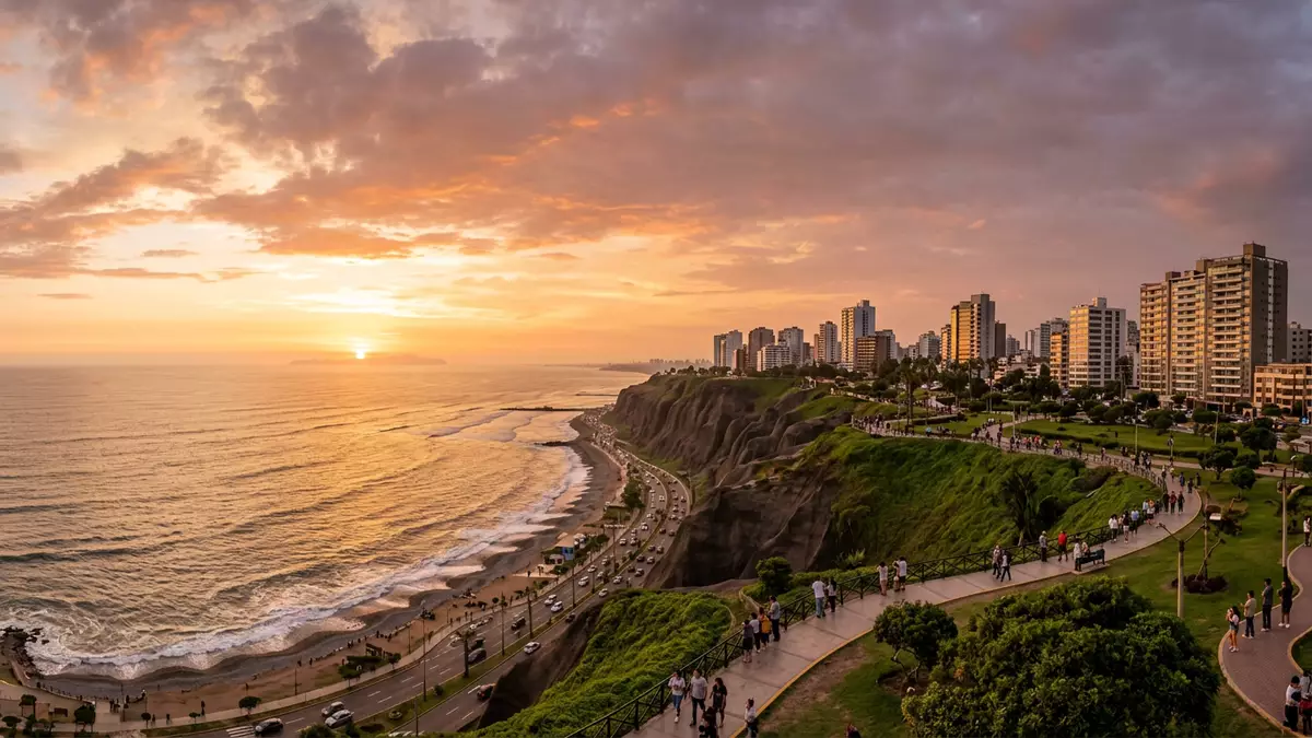
Miraflores is a coastal district of Lima where sheer cliffs, dense gardens and pre-Columbian ruins share the same strip of Pacific shoreline. It is part of the metropolitan area of Lima in Peru and has grown from an independent town into one of the city’s most recognisable districts, combining a formal urban grid with open parkland along the edge of the ocean.
Clifftop parks and the Pacific edge of Lima
Miraflores occupies a band of territory on the western side of Lima, with the Pacific Ocean directly to the west and neighbouring districts such as San Isidro and Barranco inland and along the coast.The district is formally recorded as one of forty-three districts of the province of Lima and its boundary with the ocean is marked by cliffs rather than flat beaches.It lies south of central Lima on the Pacific coast
The most striking continuous feature along this edge is the Malecón de Miraflores, a sequence of parks and gardens arranged along the top of the cliffs. The Malecón forms a green corridor above the water, with lawns, planted beds and pathways laid out parallel to the line of the coast.Descriptions of Miraflores highlight the Malecón as a strip of parks and gardens overlooking the ocean In several sections the parkland opens into larger spaces such as Parque del Amor, where mosaic-covered walls and a large sculpture occupy a terrace near the cliff edge.
Larcomar, Parque del Amor and the seafront landmarks
Within the clifftop sequence, specific landmarks have become associated with Miraflores in guidebooks and travel writing. Larcomar is a multi-level shopping and leisure complex integrated into the cliff, with terraces that look out over the Pacific and open-air circulation spaces rather than enclosed corridors.Travel guides describe Miraflores as offering upscale shopping in outdoor malls such as Larcomar, reached directly from the clifftop promenade Close by, Parque del Amor contains mosaic benches, patterned surfaces and the well-known statue “El Beso” showing a couple embracing above the ocean.The park is recorded as featuring the sculpture “El Beso” by Victor Delfin, installed in February 1993
Towards one end of the Malecón stands a lighthouse known locally as Faro La Marina, a slender tower rising from a lawn that marks the line of the cliffs.Accounts of Miraflores include the lighthouse among the main points along the Malecón The open lawns near the lighthouse and Parque del Amor double as take-off areas for paragliding, using the height of the cliffs above the shoreline. Below the cliffs, a band of coastal road runs along the base, with beaches arranged in segments between rocky outcrops.
Huaca Pucllana and traces of earlier cultures
Miraflores is not only defined by its modern parks and shopping streets; within its grid of urban blocks stands Huaca Pucllana, a large adobe and clay structure that predates the Spanish foundation of Lima.Huaca Pucllana is described as an adobe and clay pyramid built from seven staggered platforms Archaeological studies attribute Huaca Pucllana to the Lima Culture, a coastal civilisation that developed in the central Peruvian region between about 200 and 700 AD.The site is recorded as a ceremonial and administrative centre for the Lima Culture in that period
The visible structure consists of terraced platforms made from small, hand-shaped bricks of clay and adobe, stacked to form sloping faces and horizontal surfaces. Within Miraflores the huaca stands as a reminder that the area formed part of a pre-Columbian landscape of ceremonial buildings long before the colonial city grid extended to the coast. It sits today within the urban fabric as an archaeological zone surrounded by streets and residential buildings, connecting the contemporary district to an earlier period of coastal settlement.
Neighbourhood character and urban layout
Beyond the seafront parks and the huaca, Miraflores functions as an urban district with residential areas, commercial strips and civic spaces. Encyclopaedic descriptions classify it as a residential and shopping district within metropolitan Lima, one of the more affluent districts in the city.Miraflores is recorded as a wealthy residential and upscale shopping district and a main tourist destination of Lima Its streets carry a mix of mid-rise apartment buildings, older houses and modern offices, with Kennedy Park acting as a central green space within the commercial core.
Historically, Miraflores developed from an independent town established during the Spanish colonial period and became integrated into Lima as the city expanded.Reports on the district describe Miraflores as having origins in a Spanish town of the sixteenth century that later became a district of Lima The modern district covers an area of just under 10 km² and sits at an altitude of around 79 to 80 m above sea level, reflecting the height of the cliffs above the ocean.Its area is recorded as 9.62 km² with an elevation near 80 m, and borders districts including Surquillo, San Isidro, Barranco and Santiago de Surco
Visiting Miraflores: what travellers from Western Europe should know
- Miraflores lies on the Pacific coast in the southwest part of Lima, bordered inland by districts such as San Isidro, Surquillo and Santiago de Surco and to the south by Barranco.
- The seafront is defined by cliffs rather than a level promenade, so movement between the Malecón on the clifftop and the beaches below involves significant changes in height using roads, ramps or stairways.
- The Malecón’s parks, including areas around Parque del Amor and the lighthouse, form a continuous corridor of lawns and planted beds above the shoreline, with paved paths that can be followed for several kilometres.
- Huaca Pucllana stands within the urban grid away from the cliffs, so reaching it from the seafront involves walking or driving through residential and commercial streets with standard city gradients.
- The official language is Spanish and the currency is the Peruvian sol.
Searching for Miraflores on social platforms
These links open searches for Miraflores on each platform.
Frequently asked questions about Miraflores
Where is Miraflores within Lima?
Miraflores is a district on the Pacific coast in the southwest of Lima, bordered by districts such as San Isidro, Surquillo, Santiago de Surco and Barranco and forming part of the Lima–Callao metropolitan area.
What should a visitor expect on a first walk through Miraflores?
A first walk usually combines the clifftop parks of the Malecón, with lawns and mosaic terraces above the ocean, and the more urban spaces around Kennedy Park and the streets leading towards Huaca Pucllana.
What makes Miraflores distinctive among Lima’s districts?
Miraflores is distinctive for its combination of high coastal cliffs lined with continuous parkland, major seafront landmarks such as Larcomar and Parque del Amor, and the prominent pre-Columbian site of Huaca Pucllana within its urban grid.


