
Mgahinga Gorilla National Park and the volcanoes above Kisoro
Published on 09/15/2026 at 07:19 | Editorial responsibility: Rafael Müller, Editor-in-Chief AD HOC NEWS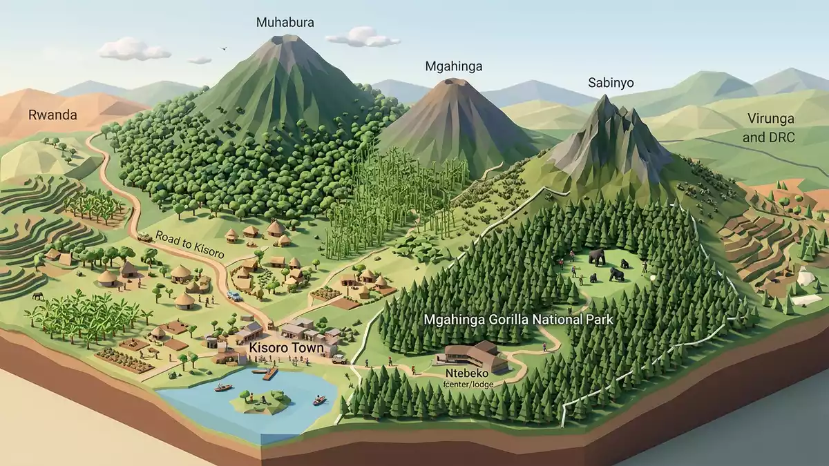
Mgahinga Gorilla National Park in southwestern Uganda is a small, steep-sided national park where three extinct volcanoes rise above the town of Kisoro and the borderlands with Rwanda and the Democratic Republic of Congo. It was gazetted as a national park in 1991 and protects montane forest and bamboo habitat used by endangered mountain gorillas and golden monkeys.
Volcanic peaks on the edge of three countries
The geography of Mgahinga Gorilla National Park is dominated by the Ugandan slopes of three volcanoes in the Virunga range: Mount Muhabura, Mount Gahinga and Mount Sabyinyo.three extinct volcanoes The park lies in Bufumbira County in Kisoro District, bordered by Rwanda to the south and the Democratic Republic of Congo to the west, so the ridgelines look out across two international frontiers.bordered by Rwanda and the DRC
Mgahinga Gorilla National Park covers roughly 33.7 km² (13.0 sq mi), making it the smallest of Uganda’s national parks.33.7 km² land area Within this compact area, elevation ranges from around 2,200 m to over 4,100 m (7,200 to 13,500 ft), and vegetation bands change with height, from lower montane forest to bamboo belts, heathland and high-altitude zones with giant lobelias and other afro-alpine plants.elevations and vegetation zones
From game sanctuary to national park for mountain gorillas
Conservation status at Mgahinga has a history reaching back to the early twentieth century, when the area was declared a game sanctuary under British administration in 1930.declared a game sanctuary in 1930 In May 1991 the Ugandan parliament passed a resolution to gazette the forest and parts of the earlier Gorilla Game Reserve as Mgahinga Gorilla National Park, with boundaries following a contour and enclosing the steep volcanic slopes.gazetted as a national park in 1991
The park forms part of the wider Virunga Conservation Area alongside Virunga National Park in the Democratic Republic of Congo and Volcanoes National Park in Rwanda, a transboundary landscape created to protect mountain habitats used by critically endangered mountain gorillas.Virunga Conservation Area Gorillas move across the borders between these parks, and Mgahinga Gorilla National Park holds a single habituated gorilla group alongside unhabituated animals that range over the massif.one habituated gorilla group
Landscape, wildlife and walking the slopes above Kisoro
Mgahinga Gorilla National Park lies roughly 10 to 15 km south of Kisoro town, with the main Ntebeko gate reached by a road climbing into the volcanic foothills.Ntebeko gate near Kisoro Within the park, trails rise through montane forest and bamboo to open heath and rocky ground, and the slopes provide habitat for golden monkeys, duikers, buffalo and forest birds alongside the gorillas.golden monkeys and other wildlife
The peaks themselves are a draw for hikers, with routes on mountains such as Muhabura and Sabyinyo offering long ascents over rough volcanic terrain and views across the Virunga volcano chain. Kisoro serves as the nearest town to Mgahinga Gorilla National Park, and the wider region combines steep cultivated hillsides, crater lakes and vistas towards the neighbouring parks in Rwanda and the Democratic Republic of Congo.park location in Kisoro District
Visiting Mgahinga Gorilla National Park: what travellers from Western Europe should know
- Mgahinga Gorilla National Park is in the extreme south-western corner of Uganda, in Kisoro District, reached by road from Kampala via Kabale and Kisoro or by flights to Kisoro airfield.
- The terrain inside the park is steep and at altitude, with trails that climb through forest and bamboo onto rough volcanic slopes, so walks involve sustained gradients and uneven underfoot conditions.
- The park borders Rwanda and the Democratic Republic of Congo, and viewpoints on the high ridges look across the Virunga volcanoes in all three countries.
- The official language is English and the currency is the Ugandan shilling.
- Entry requirements depend on your nationality; UK travellers can check the FCDO travel advice at gov.uk/foreign-travel-advice, Irish travellers the Department of Foreign Affairs at ireland.ie.
Searching for Mgahinga Gorilla National Park on social platforms
These links open searches for Mgahinga Gorilla National Park on each platform.
Frequently asked questions about Mgahinga Gorilla National Park
Where is Mgahinga Gorilla National Park in relation to Kisoro?
Mgahinga Gorilla National Park lies in Bufumbira County in Kisoro District, roughly south of Kisoro town near the borders with Rwanda and the Democratic Republic of Congo.
What should visitors expect on a visit to Mgahinga Gorilla National Park?
Visitors encounter steep volcanic slopes with montane forest, bamboo and heathland, and the possibility of wildlife such as mountain gorillas, golden monkeys and forest birds along marked trails.
What makes Mgahinga Gorilla National Park distinctive among Uganda’s parks?
Mgahinga Gorilla National Park is Uganda’s smallest national park and part of the Virunga Conservation Area, combining three volcanic peaks with habitat for critically endangered mountain gorillas.


