
Mauao, the lava dome guarding Tauranga Harbour
Published on 09/21/2026 at 21:57 | Editorial responsibility: Rafael Müller, Editor-in-Chief AD HOC NEWS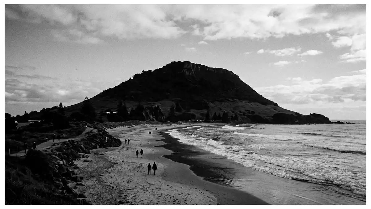
Mauao is the volcanic hill that forms the headland at the entrance to Tauranga Harbour on the Bay of Plenty coast of New Zealand’s North Island, rising above the suburb that shares its name.The lava dome reaches about 232 m (761 ft) above sea level, compact enough to climb yet high enough to command wide views over harbour, town and Pacific surf.
An ancestral lava dome between harbour and ocean
Mauao is a rhyolite lava dome at the seaward end of a sandy tombolo that links the hill to the mainland, creating a narrow neck of land between Tauranga Harbour and the open Pacific Ocean.Geologists describe the dome as volcanic in origin, formed from viscous lava that solidified into the rounded hill seen today. On one side lies Pilot Bay and the sheltered harbour channel; on the other, an exposed ocean beach runs for kilometres along the Bay of Plenty coast.The conical hill dominates the largely flat surrounding terrain, making it a visible marker from sea and shore.
The rock of Mauao is cut by paths and terraces, but its overall form remains that of a compact dome rising directly from sea level. The summit area is relatively small, with grassy patches, low scrub and exposed bedrock, and drops steeply to lower flanks where tracks loop around the base and climb the slopes.The difference between the flat shoreline and the steep hill creates a sharp transition as the tracks leave the seaside promenade and begin to climb. From the upper slopes, the harbour mouth, sandbars and industrial wharves of Tauranga line up in a single panorama, with the curve of the Pacific beach stretching away along the coast.
The meaning of Mauao and its M?ori stories
Mauao is more than a landmark of rock and paths; it is recognised as a sacred t?ranga maunga, or ancestral mountain, for Tauranga Moana iwi including Ng?i Te Rangi, Ng?ti P?kenga, Ng?ti Ranginui and the iwi Waitaha.The mountain is owned by local iwi and jointly managed by the Mauao Trust and Tauranga City Council, reflecting its cultural significance as well as its recreational role. Its M?ori name, Mauao, is widely translated as “caught in the light of the day” or “caught by the dawn”.The meaning is tied to traditions that tell of an unnamed hill fixed in place by sunrise at the harbour entrance.
In these traditions, Mauao is described as a hill whose love for the mountain P?whenua was not returned, leading to a desire to end his life in the ocean. Fairy-like forest beings known as patupaiarehe are said to have hauled the hill towards the coast, dragging it across the landscape towards the sea.As sunrise approached, the hill became fixed at the harbour mouth, and the name Mauao, meaning caught by the morning light, was given. The story places the mountain in a network of named peaks, forests and sea channels, with Tauranga Moana as the setting in which landforms are imbued with personality and memory.
Tracks, viewpoints and the everyday hill of Tauranga
Although Mauao carries deep ancestral meaning, it also functions as a public reserve where tracks link the shoreline to viewpoints on the slopes and summit.The main summit routes rise from the base, climbing steadily to the 232 m (761 ft) high point, while a separate track encircles the base close to the water, offering a level loop between harbour and ocean. Named tracks such as Oruahine and Waikorire approach the summit from the ocean side, meeting near the top where a short final climb reaches the grassy crest.These routes are described as requiring a reasonable level of fitness, with sections of sustained gradient.
From the summit, the view falls in several directions at once: across the harbour to Tauranga’s port infrastructure and city centre, along the sandy ocean beach towards P?p?moa, and out into the Bay of Plenty, where the coastline curves and offshore islands break the horizon.Travel features describe the panorama as taking in Tauranga Harbour, the Pacific coastline and inland ranges. Closer at hand, the tracks reveal cliffs, grassy slopes and pockets of coastal forest, while small clearings and benches on lower terraces offer intermediate viewpoints above the surf and ship channel.
Visiting Mauao: what travellers from Western Europe should know
- Mauao stands at the entrance to Tauranga Harbour in the Bay of Plenty region on New Zealand’s North Island, rising above the suburb of the same name; Tauranga is south-east of Auckland.
- The hill is steep in places, with summit tracks that climb from sea level to about 232 m (761 ft); sections of the paths involve sustained gradients and stair-like steps on compacted surfaces.
- The base track runs close to the shoreline and stays relatively level compared with the summit routes, but parts of it pass beneath cliffs where the terrain can feel exposed.
- The official language is M?ori and English and the currency is the New Zealand dollar.
- Entry requirements depend on your nationality; UK travellers can check the FCDO travel advice at gov.uk/foreign-travel-advice, Irish travellers the Department of Foreign Affairs at ireland.ie.
Searching for Mauao on social platforms
These links open searches for Mauao on each platform.Frequently asked questions about Mauao
Where is Mauao located?
Mauao stands at the entrance to Tauranga Harbour in the Bay of Plenty region on New Zealand’s North Island, rising above the suburb that shares its name.
What can visitors expect on a visit to Mauao?
Visitors encounter a coastal hill with tracks around the base and up to the summit, where views stretch across Tauranga Harbour, the Pacific beach and inland ranges.
What makes Mauao distinctive among New Zealand hills?
Mauao combines a compact lava dome, an accessible summit above both harbour and ocean, and recognised status as an ancestral mountain for Tauranga Moana iwi.


