
Mauao above Tauranga Harbour
Published on 09/17/2026 at 22:47 | Editorial responsibility: Rafael Müller, Editor-in-Chief AD HOC NEWS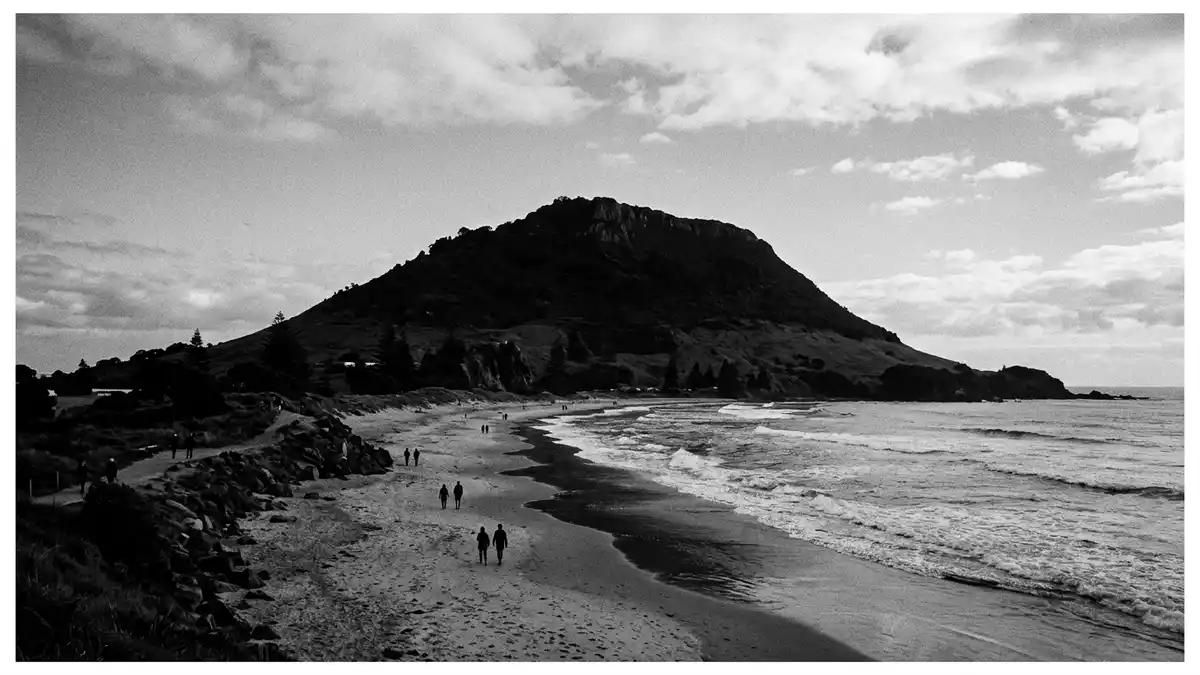
Mauao is a volcanic dome at the entrance to Tauranga Harbour on New Zealand’s North Island, rising above the suburb that shares the mountain’s English name. Formed of rhyolitic lava and standing a little over 230 m (around 750 ft) above sea level, it is both a coastal landmark and an ancestral mountain with deep significance for M?ori communities in the Bay of Plenty region.
A volcanic dome framing sea and harbour
Mauao stands on a tombolo that links the dome to the mainland, with the Pacific Ocean on one side and Tauranga Harbour on the other.The lava dome reaches about 232 m (761 ft), giving it enough height to dominate the headland without becoming a high mountain in alpine terms.Geological surveys describe Mauao as composed largely of Pleistocene rhyolite, part of the wider volcanic story of the Bay of Plenty coast.
The dome forms the eastern side of the harbour entrance together with Matakana Island, enclosing a sheltered body of water behind the low headland.From the summit, the view extends over the sand bar, the harbour channels and the wider Tauranga urban area, while the ocean face drops towards surf beaches and the open bay.Walking routes climb from the coastal base around the ocean side and harbour side, tracing the dome’s contours in a series of zigzags and terraces.
Ancestral mountain of Tauranga Moana iwi
For M?ori communities around Tauranga, Mauao is more than a scenic headland: it is the sacred t?puna maunga, or ancestral mountain, of local iwi including Ng?i Te Rangi, Ng?ti P?kenga, Ng?ti Ranginui and the iwi Waitaha.Historic accounts and cultural narratives describe Mauao as the spiritual home of Tauranga Moana, connected with legends of unrequited love and transformation that give the mountain its name.In te reo M?ori the name Mauao is linked to the phrase “caught in the light of the day”, reflecting its position at the harbour entrance where the rising sun touches the summit early.
The land around the dome is formally recognised as the Mauao Historic Reserve, a protected cultural landscape covering several tens of hectares.Archaeological mapping identifies multiple p? complexes on the slopes and summit area, with terraces, storage pits, house platforms and shell middens marking centuries of occupation.Ownership of the reserve lies with local iwi through the Mauao Trust, and management is shared with Tauranga City Council through a joint administration board that guides conservation and access.
Walking the headland and reading the landscape
Mauao’s rounded form and steep flanks give walking routes a clear progression from sea level to the summit, transitioning from beachside boardwalks to rougher tracks and staircases in the upper sections.Named routes such as the Oruahine and Waikorire tracks begin near the surf lifesaving club on the ocean side, climbing through regenerating coastal vegetation and past rocky outcrops that reveal the rhyolitic character of the dome.A separate base track loops around the foot of the mountain, keeping close to the shoreline and giving contrasting views of the harbour, ocean beach and the low land bridge that ties the dome to the suburb behind.
Seen from these paths, the landscape tells several stories at once. The volcanic origin appears in the dark lava forms and broken rock faces facing the Pacific swells, while the harbour side shows quieter slopes dropping towards mudflats, tidal channels and urban wharves.Ecological reports note that the dome lies within the Tauranga Ecological District of the Northern Volcanic Plateau region, and the mixture of coastal scrub, grassed terraces and regenerating native species reflects that position between marine and terrestrial systems.Management plans emphasise protection of archaeological features and natural values alongside recreational use, so even a short circuit on the lower flanks passes earthworks and terraces that once supported fortified settlements.
Visiting Mauao: what travellers from Western Europe should know
- Mauao stands at the entrance to Tauranga Harbour on New Zealand’s North Island, linked to the city by coastal roads and the low-lying sand bar that carries the Mount Maunganui suburb.
- The walking tracks climb steadily from sea level to over 230 m (around 750 ft), with sections of steep gradient and staircases on the upper slopes that demand sure footing and moderate fitness.
- The official language is M?ori and English, and the national currency is the New Zealand dollar.
- Entry requirements depend on your nationality; UK travellers can check the FCDO travel advice at gov.uk/foreign-travel-advice, Irish travellers the Department of Foreign Affairs at ireland.ie.
Searching for Mauao on social platforms
These links open searches for Mauao on each platform.
Frequently asked questions about Mauao
Where is Mauao and what kind of place is it?
Mauao is a volcanic dome at the entrance to Tauranga Harbour on New Zealand’s North Island, forming the coastal headland beside the suburb that shares its English name.
What can visitors expect when walking Mauao?
Visitors encounter coastal boardwalks, steadily climbing tracks and staircases that lead through a historic reserve with terraces, archaeological earthworks and wide views over the harbour and Pacific Ocean.
What makes Mauao distinctive compared with other coastal hills?
Mauao combines a rhyolitic lava dome, an extensive archaeological landscape of former p? sites and its role as the sacred ancestral mountain of Tauranga Moana iwi, all set above a major harbour entrance.


