
Machu Picchu’s stone terraces above Aguas Calientes
Published on 08/26/2026 at 06:21 | Editorial responsibility: Rafael Müller, Editor-in-Chief AD HOC NEWS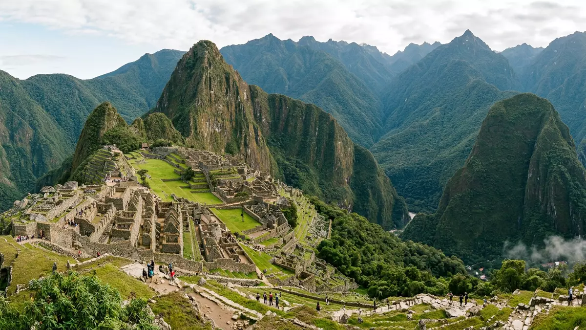
Machu Picchu is a fifteenth-century Inca citadel built high in the Andes above the town of Aguas Calientes in southern Peru. Set on a ridge between steep peaks, it combines stone terraces, temples and dwellings with sheer drops into the Urubamba valley below.
Stonework on a high Andean ridge
Machu Picchu occupies a saddle between the prominent peak of Huayna Picchu and the narrower ridge that carries its main terraces, in the Cusco Region of Peru. The site stands at about 2,430 m (7,970 ft) above sea level, above a bend of the Urubamba River in a landscape of deep canyons and cloud forest ridges.Machu Picchu sits at approximately 2,430 metres above sea level The nearest settlement is Aguas Calientes, also known as Machu Picchu Pueblo, which lies beside the river at a lower elevation.
The core of the citadel consists of finely worked granite buildings arranged along narrow streets and open squares. Retaining walls support agricultural terraces that step down the slopes, while stairways link platforms and courtyards across sharp changes in level.The site includes houses, temples and agricultural terraces The combination of masonry, steep topography and surrounding peaks gives the place a distinctive profile when seen from above or from neighbouring paths.
An Inca estate from the fifteenth century
Machu Picchu dates to the height of the Inca Empire in the mid fifteenth century. Archaeological and radiocarbon studies place its construction and occupation between around 1450 and the early sixteenth century, during the reign of the Inca ruler Pachacuti Inca Yupanqui.Radiocarbon testing places the date of Machu Picchu’s construction around 1450 during the reign of Pachacutec Pachacuti governed from 1438 to 1471 and expanded the Inca state into a far-reaching Andean empire.The construction of Machu Picchu is attributed to Pachacuti Inca Yupanqui, who ruled from 1438 to 1471
The site formed part of a wider network of Inca settlements and ceremonial locations in the region around Cusco. It was abandoned in the sixteenth century as Spanish conquest disrupted Inca rule and populations, and vegetation gradually covered many of its walls.Machu Picchu was built in the fifteenth century and abandoned when the Inca Empire was conquered in the sixteenth century Local residents in the surrounding valleys retained knowledge of the ruins long after state structures collapsed.
From local site to World Heritage sanctuary
The ruins of Machu Picchu entered wider international awareness in 1911, when the American historian Hiram Bingham III reached the site with the help of local guides from the region around Aguas Calientes.Hiram Bingham was led to Machu Picchu by a local resident in 1911 Bingham’s reports and photographs drew attention to the Inca stonework and the dramatic mountain setting, and further archaeological work followed.American explorer Hiram Bingham arrived in 1911, guided by local residents, and published reports that drew international attention
In 1981 the Peruvian government created the Historic Sanctuary of Machu Picchu as a protected area, covering both the archaeological site and surrounding cloud forest slopes.The area was created as a National Historical Sanctuary in 1981 Two years later, UNESCO inscribed the Historic Sanctuary of Machu Picchu on the World Heritage List, recognising both its cultural and natural significance.The Historic Sanctuary of Machu Picchu was inscribed on the World Heritage List in 1983 The sanctuary status links the stone structures with the surrounding mountain environment, where steep ridges meet forested slopes and river gorges.
Visiting Machu Picchu: what travellers from Western Europe should know
- Machu Picchu stands in the Cusco Region of southern Peru, above the town of Aguas Calientes in the valley of the Urubamba River. The site lies inland from the Pacific coast and is usually approached from Cusco by rail and road, with Aguas Calientes acting as the final staging point.
- The citadel occupies a high ridge with significant changes in level between terraces, plazas and paths. Visiting involves walking on stone steps, uneven surfaces and sloping paths at around 2,430 m (7,970 ft), and the surrounding mountains rise steeply from the valley floor.
- Aguas Calientes lies below the site beside the Urubamba River and is surrounded by high forested slopes. The town’s streets and bridges span the river and the railway line, and the settlement functions as the main base for reaching the archaeological area above.
- The official language of Peru is Spanish and the currency is the Peruvian sol. Entry requirements depend on your nationality; UK travellers can check the FCDO travel advice at gov.uk/foreign-travel-advice, Irish travellers the Department of Foreign Affairs at ireland.ie.
Searching for Machu Picchu on social platforms
These links open searches for Machu Picchu on each platform.
Frequently asked questions about Machu Picchu
Where is Machu Picchu located?
Machu Picchu lies in the Cusco Region of southern Peru, on a ridge above the Urubamba River near the town of Aguas Calientes in the eastern Andes.
What should a visit to Machu Picchu be expected to involve?
A visit involves walking on stone terraces, stairways and paths at high altitude, with steep drops beside many routes and significant changes in level across the site.
What makes Machu Picchu distinctive among archaeological sites?
Machu Picchu combines finely crafted Inca stone architecture with a dramatic mountain setting, linking temples, terraces and dwellings to cloud forest ridges in a single protected sanctuary.


