
Lineas de Nazca and the giant drawings of the Peruvian desert
Published on 08/26/2026 at 20:24 | Editorial responsibility: Rafael Müller, Editor-in-Chief AD HOC NEWS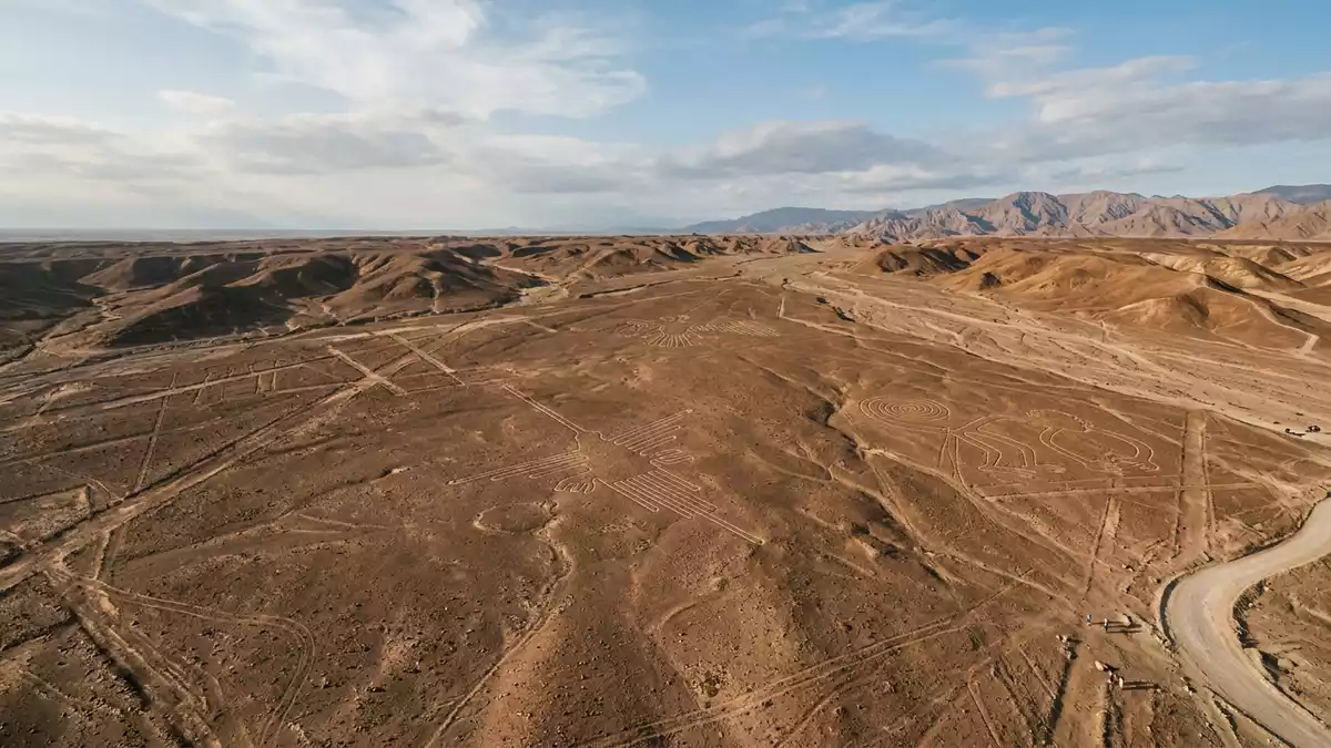
Lineas de Nazca, known in English as the Nazca Lines, spread across the dry plateau between Nazca and Palpa in southern Peru and turn an otherwise bare desert into an enormous drawn landscape. Extending over a wide area of coastal plain, these ancient ground drawings form figures, lines and shapes that can be traced across the pampas for kilometres and are now recognised as a major archaeological site with World Heritage status.
A desert canvas of lines and figures
The Nazca Desert lies inland from the Peruvian coast, in the Ica Region, on a plateau that stretches between the towns of Nazca and Palpa over tens of kilometres.plateau between Nazca and Palpa The ground here is a natural canvas of reddish stones and pale soil, and the geoglyphs harness that contrast. The makers scraped away the darker surface material to expose a lighter subsoil, producing ground-level drawings that remain visible because the region receives very little rain or wind.scraped away the dark top soil
The figures and lines cover a large tract of desert plain, with different sources placing the area in the hundreds of square kilometres.extend over nearly 500 square km Within that expanse are straight lines that run for many kilometres, geometric forms such as trapezoids and patterns, and stylised representations of animals and plants. Hummingbirds, monkeys, spiders and other creatures appear as ground drawings, some spanning lengths that rival the height of tall city towers.animal and plant designs
Ancient makers and modern recognition
The geoglyphs of Lineas de Nazca are part of a wider archaeological landscape now formally inscribed as Lines and Geoglyphs of Nasca and Palpa on the UNESCO World Heritage List.Lines and Geoglyphs of Nasca and Palpa UNESCO records the site under cultural criteria i, iii and iv, recognising it as a masterpiece of human creative genius and an outstanding testimony to ancient traditions on the south coast of Peru.criteria i iii and iv The protected area covers tens of thousands of hectares and includes desert plains in the provinces of Nazca and Palpa.
Archaeological work links the majority of the designs to the Nazca culture, a pre-Inca society that flourished on the Peruvian south coast in the first centuries AD.Nazca people flourished from around AD 1 to 700 The wider geoglyph tradition in the region is recorded from around the eighth century BC through to the eighth century AD, with many of the lines and biomorphs falling between roughly 200 BC and AD 600.created between 200 BCE and AD 600 The combination of endurance in a harsh climate and scale across the desert has made Lineas de Nazca a key reference point for research into ancient Andean societies.
Seeing Lineas de Nazca from above and on the ground
Lineas de Nazca lie northwest of the town of Nazca on a windswept plateau often referred to as the Pampa Colorada or related pampas, where the contrast between stone and soil is clearly visible.arid Pampa Colorada northwest of Nazca The closest urban centre is Nazca itself, a town on the Panamericana Sur highway that connects the Ica Region with Lima and other coastal cities.region of Ica along PE-1S Panamericana Sur Travellers reach the area by road across the coastal desert, and many viewpoints lie close to the highway where the plateau opens.
Because the figures and lines stretch over such large distances, the overall compositions are most clearly appreciated from an elevated vantage. Observation structures beside sections of the highway provide raised views over selected designs, and flights in light aircraft follow routes over portions of the plateau, tracing sequences of figures, trapezoids and lines that cannot be grasped at ground level. On the desert floor the lines appear as shallow cleared tracks, while from higher up they form coherent images aligned across the open pampas.
Visiting Lineas de Nazca: what travellers from Western Europe should know
- Lineas de Nazca lie in southern Peru’s Ica Region, with road access along the Panamericana Sur highway to Nazca and nearby desert viewpoints.
- The terrain is an exposed desert plateau with soft ground and stones, so walking areas can involve uneven surfaces and low roadside steps to viewing platforms.
- The wider setting is an arid coastal desert inland from the Pacific, and daytime visits take place under strong sunlight with limited natural shade on the plateau.
- The official language is Spanish and the currency is the Peruvian sol.
- Entry requirements depend on your nationality; UK travellers can check the FCDO travel advice at gov.uk/foreign-travel-advice, Irish travellers the Department of Foreign Affairs at ireland.ie.
Searching for Lineas de Nazca on social platforms
These links open searches for Lineas de Nazca on each platform.
Frequently asked questions about Lineas de Nazca
Where are Lineas de Nazca located within Peru?
Lineas de Nazca are on an arid plateau in the Ica Region, between the towns of Nazca and Palpa in southern Peru, inland from the Pacific coast.
What should visitors expect when they arrive at Lineas de Nazca?
Visitors encounter a broad desert plain crossed by cleared ground drawings, with views from roadside platforms and flights in small aircraft giving an overview of the extended figures.
What makes Lineas de Nazca distinctive among archaeological sites?
Lineas de Nazca are distinctive for their scale, with hundreds of geoglyphs etched into a single desert plateau and animal figures only fully visible from above.


