
Li Jiang and the limestone hills of Guilin
Published on 09/24/2026 at 08:05 | Editorial responsibility: Rafael Müller, Editor-in-Chief AD HOC NEWS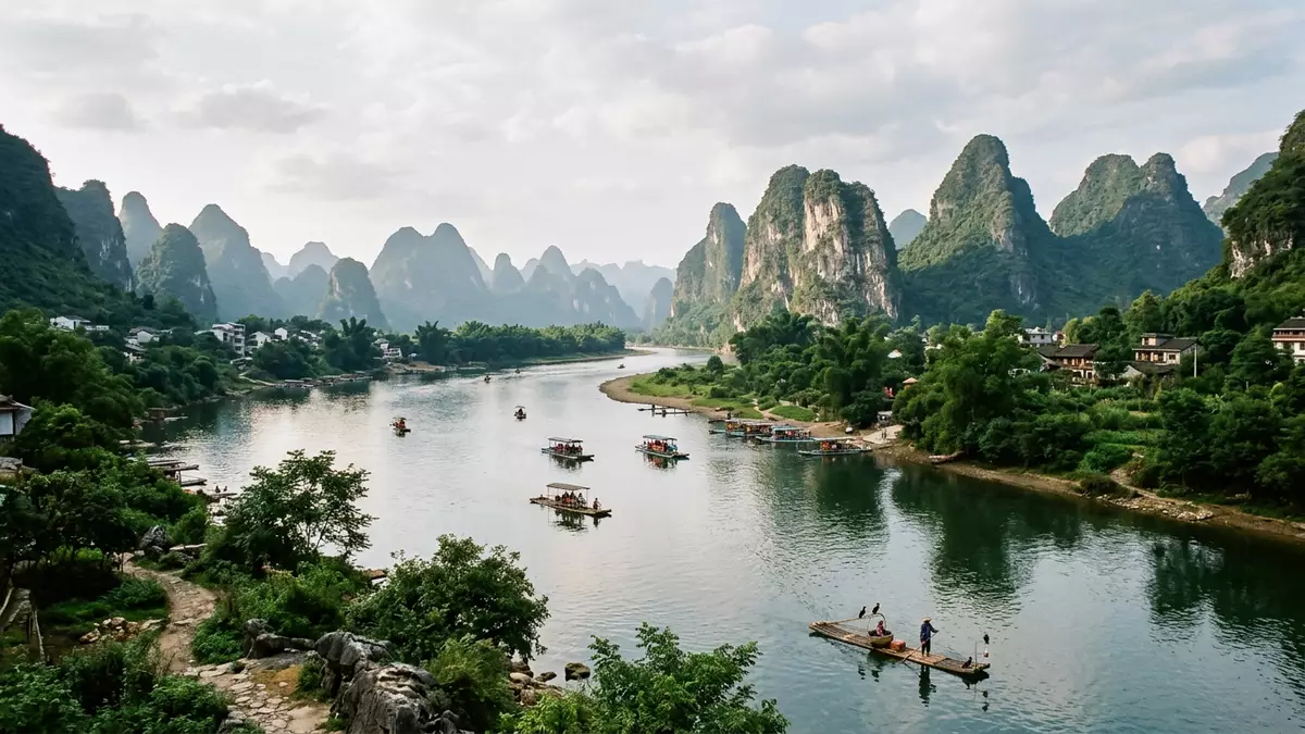
Li Jiang is the river landscape most closely associated with Guilin in southern China. Its defining scene is a waterway bordered by steep limestone hills, with Guilin to the north and Yangshuo farther south. The river’s changing silhouettes turn a journey along its banks into a passage through China’s celebrated karst country.
Li Jiang between Guilin and Yangshuo
The name Li Jiang refers to the upper course of the Gui River. The river rises in the Mao’er Mountains north of Guilin, in Guangxi, and flows south through Guilin and Yangshuo before joining the wider Xi River system. The full river course is 437 kilometres long, while the scenic waterway between Guilin and Yangshuo covers about 83 kilometres.
Mao’er Mountain reaches 2,141.5 metres and forms the river’s northern source area. From there, Li Jiang passes through a basin of limestone relief, agricultural land and settlements. Guilin occupies the northern gateway to the landscape, while Yangshuo marks the southern end of the river journey most closely associated with the karst hills. the river’s upper course is also known as the Li River.
The karst skyline along Li Jiang
The hills beside Li Jiang belong to two related karst forms. Fenglin describes isolated tower hills rising separately from the surrounding land, while fengcong describes groups of cone-shaped hills gathered into a connected relief. Both forms appear in the Guilin Karst component of South China Karst.
The river and the hills are inseparable in the landscape. Limestone ridges rise from relatively low ground, and their profiles change as the waterway bends. Caves, steep rock faces and narrow valleys belong to the same geological setting. The World Heritage property includes Guilin Karst within Lijiang National Park, where tower and cone karst occur together. South China Karst became a World Heritage property in 2007, with the Guilin Karst component added through a later extension.
UNESCO identifies the Guilin landscape as an example of humid subtropical karst. Rainwater and flowing rivers have acted on limestone across geological time, leaving isolated hills, caves, gorges and underground drainage features. Along Li Jiang, those landforms remain visible from the water as a succession of steep green-grey forms against the open valley.
A river carried through Chinese culture
Li Jiang belongs to the visual language of Chinese landscape painting. Guilin’s hills and waterways appear in poetry, paintings and travel writing, where the river landscape is treated as a meeting point of water, rock and mist. The scenery is not confined to a single monument. It extends through the relationship between the river channel, the hills and the settlements along the banks.
Guilin also has a long history as a regional route centre. The Ling Canal connects the Xiang River system in Hunan with the upper Gui River, linking waterways that run towards the Yangtze and the Pearl River. This connection placed Guilin within a wider network of movement through southern China. Guilin’s river setting therefore combines a natural landscape with a long-established geographical position.
The river also carries several names across maps and historical descriptions. Li Jiang is the Chinese name used for the Li River, while the wider watercourse is known as the Gui River. In ancient references, the river was known as Gui Water. These names describe different parts or historical layers of the same southern Chinese river system.
Visiting Li Jiang: what travellers from Western Europe should know
- Li Jiang lies in Guangxi, southern China, with Guilin at its northern urban gateway and Yangshuo along the scenic southern course. River journeys and road connections link the two towns.
- The landscape combines water with limestone relief. Riverbank paths, boat landings and hill viewpoints can include uneven ground, steps and exposed rock.
- The river’s source area is Mao’er Mountain, north of Guilin. The mountain reaches 2,141.5 metres, while the scenic Guilin–Yangshuo section lies in a lower river basin.
- The official language is Mandarin Chinese and the currency is the Chinese yuan.
- Entry requirements depend on your nationality; UK travellers can check the FCDO travel advice at gov.uk/foreign-travel-advice, Irish travellers the Department of Foreign Affairs at ireland.ie.
Searching for Li Jiang on social platforms
These links open searches for Li Jiang on each platform.
Frequently asked questions about Li Jiang
Where is Li Jiang?
Li Jiang is in Guangxi, southern China. It flows through Guilin and continues south towards Yangshuo within the Gui River system.
What can travellers expect from the landscape?
The river is bordered by limestone hills, caves, valleys and agricultural land. The scenic course is associated with river journeys between Guilin and Yangshuo.
What makes Li Jiang distinctive?
Its identity comes from the close relationship between the waterway and the karst skyline. Tower hills, cone karst and Chinese landscape traditions meet along the same river corridor.


