
Li Jiang and the karst peaks of Guilin
Published on 09/18/2026 at 09:46 | Editorial responsibility: Rafael Müller, Editor-in-Chief AD HOC NEWS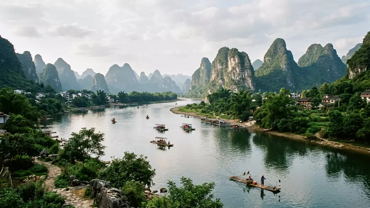
Li Jiang, known in English as the Li River, threads through Guilin in southern China as a broad green waterway framed by limestone karst peaks and riverside villages. Its meandering course, captured on China’s 20-yuan banknote, has long provided one of the most recognisable river landscapes in East Asia.
A river shaped by karst and mountains
Li Jiang forms the upper reaches of the Gui River in northeastern Guangxi, part of the wider Xijiang system within the Pearl River basin.upper reaches of the Gui River It rises in the Mao’er Mountains in Xing’an County north of Guilin, where Cat Mountain reaches over 2,000 m (6,562 ft) and feeds clear streams into the main channel.originating from Mao'er Mountain in Xing'an County From there the river flows broadly south through Guilin, Yangshuo and Pingle before joining the Xijiang River near Wuzhou.
The full course associated with Li Jiang runs for hundreds of kilometres, but the section between Guilin and Yangshuo has become the most described stretch, with about 83 km (52 mi) of waterway cutting between densely clustered karst hills.water stretches 83 kilometers from Guilin to Yangshuo These peaks rise steeply from low valley floors, forming freestanding towers and ridges of weathered limestone. The Guilin Li River National Scenic Area and the Guilin Karst World Natural Heritage Site cover much of this landscape, underlining its status as a protected river corridor within China.Guilin Li River National Scenic Area
Scenery between Guilin and Yangshuo
Within Guilin, Li Jiang passes directly through the urban area, but the river’s most widely depicted landscapes begin as the city thins out and limestone hills cluster closer to the banks.passes directly through downtown Guilin Elephant Trunk Hill, near the city, forms a natural rock arch beside the water and marks one of the first named viewpoints. Downstream, the river bends past old settlements such as Daxu Ancient Town, where traditional buildings line narrow streets set back from the water.
Further south, near Yangdi and Xingping, the channel widens and the valley opens onto views that have been compared with ink paintings: isolated peaks, groves of bamboo on gravel bars and agricultural plots on low terraces beside the river.tens of thousands of karst peaks At Nine Horse Fresco Hill, weathering on the rock face forms darker patches that suggest animal outlines; at Yellow Cloth Shoal a line of hills and reflections has been chosen as the background image on the 20-yuan note.Yellow Cloth Shoal on the 20-yuan banknote Near Xingping Ancient Town, peaks frame a quieter meander of the river, with stone houses and lanes just behind the embankment.
Li Jiang in culture and conservation
The landscapes along Li Jiang have appeared in Chinese poetry and painting for centuries, and Guilin’s name, meaning “Forest of Osmanthus”, reflects the trees that line parts of the valley.gateway to the Li River for over a thousand years The combination of steep karst towers, calm water and working farmland has helped establish a visual pattern now strongly associated with southern China’s interior river scenery. On the river itself, working boats, local ferries and larger cruise vessels share the channel, while in narrower side arms smaller craft serve nearby villages.
Environmentally, Li Jiang forms part of a nationally protected river system. It is listed among major protected rivers in China and lies within a core zone that also includes the Guilin Karst Global Geopark.China’s 13 nationally protected major rivers This status reflects both hydrological importance and the karst formations that flank the water. Rock faces, caves higher on the hills and forested slopes above cultivated riverbanks together form a landscape that is formally recognised as part of a World Natural Heritage site.
Visiting Li Jiang: what travellers from Western Europe should know
- Li Jiang flows through Guilin in the Guangxi Zhuang Autonomous Region of China, with many river journeys beginning in Guilin and ending in Yangshuo along the southern course.
- The river valley between Guilin and Yangshuo is lined with limestone hills and farmland, and excursions can involve walking on uneven paths, stone steps and simple embankments beside the water.
- Along the river there are named viewpoints such as Elephant Trunk Hill near Guilin and Yellow Cloth Shoal and Nine Horse Fresco Hill closer to Yangshuo, reached by boat landings or short walks.
- The official language is Chinese and the currency is the renminbi (yuan).
- Entry requirements depend on your nationality; UK travellers can check the FCDO travel advice at gov.uk/foreign-travel-advice, Irish travellers the Department of Foreign Affairs at ireland.ie.
Searching for Li Jiang on social platforms
These links open searches for Li Jiang on each platform.
Frequently asked questions about Li Jiang
Where is Li Jiang?
Li Jiang flows through Guilin and Yangshuo in the Guangxi Zhuang Autonomous Region of southern China and forms the upper reaches of the Gui River.
What can visitors expect on a journey along Li Jiang?
A journey along Li Jiang between Guilin and Yangshuo passes limestone karst peaks, farmland, villages and named viewpoints such as Elephant Trunk Hill and Yellow Cloth Shoal.
What makes Li Jiang distinctive among rivers in China?
Li Jiang is distinctive for its corridor of steep limestone karst hills, its protected scenic status and the way its Guilin–Yangshuo landscapes have entered Chinese art and banknote design.


