
Lake Tekapo and its turquoise alpine basin in New Zealand
Published on 09/07/2026 at 13:20 | Editorial responsibility: Rafael Müller, Editor-in-Chief AD HOC NEWS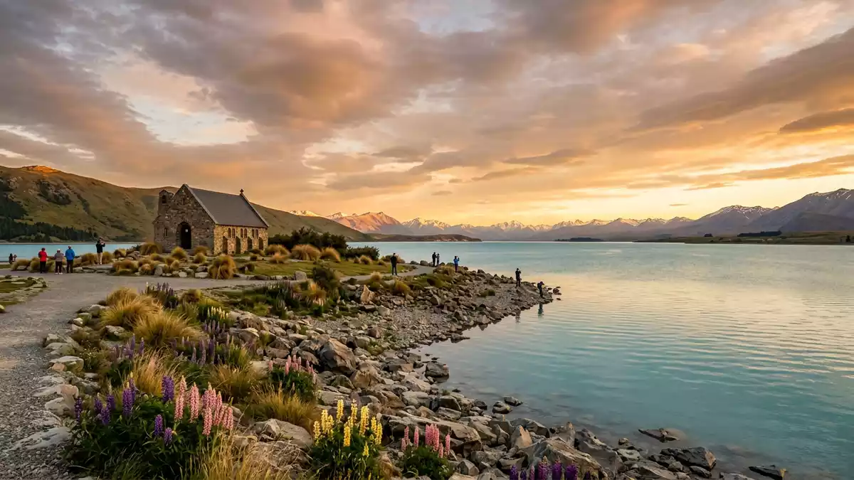
Lake Tekapo in New Zealand’s South Island is a high alpine lake with striking turquoise water, framed by the Mackenzie Basin and a small settlement on its southern shore. Set amid the Canterbury region and bordered by mountain ranges, it combines glacial geography, a compact township and wide skies into one landscape.
An alpine lake shaped by ice and rock
Lake Tekapo lies in the Mackenzie District of the Canterbury region on the South Island, occupying a long valley at the northern edge of the Mackenzie Basin.Mackenzie Basin setting The lake is a former glacial basin, dammed by moraine, with water fed from rivers flowing out of the Southern Alps.glacially dammed basin Its surface lies at an elevation of around 710 m (2,330 ft) above sea level, giving it a distinctly alpine character even though it is reached by road.elevated alpine lake
The lake stretches for several tens of kilometres along a north–south axis and covers more than 80 km² in area, with depths that reach well over 100 m in places.length and depth Rivers such as the Godley and Macaulay enter at the northern end, bringing meltwater from the Southern Alps, while the Tekapo River carries water away at the southern end.Godley and Macaulay rivers Finely ground glacial sediment suspended in this water gives Lake Tekapo its characteristic turquoise colour, especially visible in clear conditions.turquoise glacial colour
The settlement of Lake Tekapo and the Church of the Good Shepherd
At the southern end of the lake sits the township of Lake Tekapo, a small rural settlement that Statistics New Zealand records as covering just over 4 km².rural settlement area The town lies close to State Highway 8, the inland route through Mackenzie Country, and functions as a base for visitors exploring the surrounding lakes and nearby Aoraki / Mount Cook area.highway-linked township Low-rise buildings, lodgings and services cluster near the shore, with views across the water to ranges such as the Southern Alps to the west and the Two Thumb Range to the east.Southern Alps and Two Thumb Range
Immediately beside the lake, the Church of the Good Shepherd stands on Pioneer Drive, facing the water and the surrounding ranges.Church of the Good Shepherd This small Anglican church opened in 1935 as a memorial to the pioneers of Mackenzie Country and is registered as a Category I heritage building by Heritage New Zealand.memorial church opened in 1935 Built in stone and carefully sited so that the altar end looks out over the lake, it has become one of New Zealand’s most photographed churches, contrasting its compact form with the wide basin and high peaks behind.
M?ori name, basin landscape and dark skies
Lake Tekapo also carries the M?ori name Takap?, a term linked to the words “taka” or “teka” for a sleeping mat and “po” for night.Tekapo name origin The lake and settlement sit within a broad basin of tussock grassland, with the Southern Alps rising to the west and the Two Thumb Range forming a barrier to the east, sheltering the area from coastal weather systems.tussock basin and sheltering ranges Motuariki Island, a single island within the lake, adds another element to the water’s surface, appearing as a low landform amid the turquoise expanse.Motuariki Island in the lake
The Mackenzie Basin around Lake Tekapo is known for clear night skies and an absence of dense urban lighting, and the lake’s setting has supported the development of astronomical observatories and stargazing facilities on nearby hills.stargazing setting From the shore, the combination of high elevation, open basin and distant mountain silhouettes gives the area a distinctive sense of scale, with the lake acting as a foreground plane between low tussock and snow-covered peaks.alpine lake and peaks
Visiting Lake Tekapo: what travellers from Western Europe should know
- Lake Tekapo lies in the Mackenzie District of the Canterbury region on State Highway 8, inland from Timaru and Christchurch on New Zealand’s South Island.
- The lake and settlement sit at around 710 m (2,330 ft) elevation, with approaches that include gentle gradients and lakeside paths rather than steep alpine climbs.
- The surrounding terrain consists of open tussock grassland, lake shorelines and nearby hills, so footwear suitable for uneven ground is useful on longer walks.
- The official language is English and the currency is the New Zealand dollar.
- Entry requirements depend on your nationality; UK travellers can check the FCDO travel advice at gov.uk/foreign-travel-advice, Irish travellers the Department of Foreign Affairs at ireland.ie.
Searching for Lake Tekapo on social platforms
These links open searches for Lake Tekapo on each platform.
Frequently asked questions about Lake Tekapo
Where is Lake Tekapo?
Lake Tekapo is an alpine lake and township in the Mackenzie District of the Canterbury region on New Zealand’s South Island, reached along State Highway 8.
What can visitors expect on a visit to Lake Tekapo?
Visitors encounter turquoise glacial water, a small lakeside settlement, the stone Church of the Good Shepherd and surrounding tussock grassland framed by mountain ranges.
What makes Lake Tekapo distinctive among New Zealand lakes?
Its combination of high-elevation turquoise water, the Mackenzie Basin landscape, Motuariki Island and a heritage lakeside church creates a distinctive mix of geography and built heritage.


