
Laguna de Bacalar and the seven colours of Bacalar
Published on 09/15/2026 at 18:37 | Editorial responsibility: Rafael Müller, Editor-in-Chief AD HOC NEWS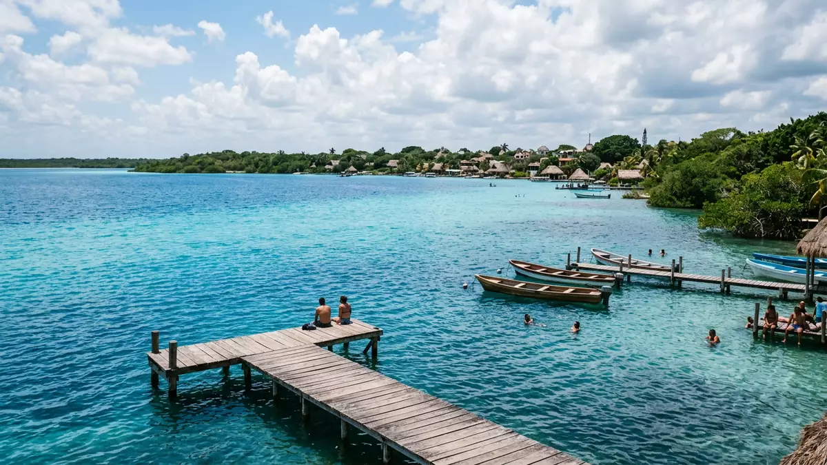
Laguna de Bacalar is a long freshwater lake on the edge of Bacalar in southern Quintana Roo, Mexico, close to the border with Belize. The lagoon is known for a striking band of blues that runs along its length, giving rise to the local name “Laguna de los Siete Colores”, the lagoon of seven colours.
A freshwater lagoon of remarkable scale
Laguna de Bacalar stretches for more than 40 km (about 25 mi) through the low-lying landscape of southern Quintana Roo, forming a narrow ribbon of water parallel to the Caribbean coast.a 42-kilometre stretch of freshwater Its width reaches around 2 km (1.2 mi) at the broadest points, yet much of the lagoon feels like an elongated corridor framed by vegetation and scattered jetties.a long, narrow freshwater lake
The lake forms one of the largest bodies of inland freshwater in Mexico, second only to Lake Chapala in overall size.the second largest freshwater lake in Mexico Unlike the nearby Caribbean Sea, Laguna de Bacalar is fed by groundwater and cenotes, the flooded sinkholes characteristic of the Yucatán Peninsula, which keep its waters clear and free of salt.aguas dulces nacidas del desbordamiento de aguas subterráneas This combination of length, narrow form and freshwater character gives the lagoon a distinct identity within the region’s network of coastal and interior waters.
Seven colours, stromatolites and cenotes
The most striking feature of Laguna de Bacalar is the succession of blue tones that appear along its surface, which locals describe as seven colours ranging from pale turquoise to deep navy.known as the Lake of Seven Colors These variations arise from changing depths, submerged features and the presence of cenotes that drop away sharply beneath the water. In places where the bottom falls into a cenote basin, the lagoon takes on darker tones, while shallower shelves close to shore show much lighter hues.
Laguna de Bacalar is also notable for living stromatolites, layered microbial structures that resemble rounded rock formations along some parts of the shore.home to an ancient population of stromatolites These formations connect the lagoon with deep geological time, as similar structures elsewhere on Earth are associated with some of the planet’s earliest life. Around them, the lagoon’s freshwater supports aquatic plants and fish typical of lowland tropical lakes, while the calm surface allows small boats and paddle craft to move easily between different inlets and channels, including the stretch known as the Pirates’ Canal.cenotes and the Pirates’ Canal
Bacalar town and the Fort of San Felipe
The town of Bacalar stands on the western shore of the lagoon, roughly 40 km (25 mi) north of Chetumal and close to the Belize frontier.about 40 km north of Chetumal Its low-rise streets run towards the water, where jetties, small piers and waterfront spaces provide direct access to the lagoon. Bacalar carries the official designation of Pueblo Mágico, a Mexican programme recognising towns with particular cultural, historical or natural interest, and the lagoon is central to that status.anchored by the Pueblo Mágico of the same name
Above the waterfront stands the Fort of San Felipe, a stone fortress dating to the eighteenth century, built under the orders of Antonio de Figueroa y Silva and designed by the Italian Juan Podio.forteresse coloniale du XVIIIe siècle The fort occupies a position overlooking the lagoon and the town’s central square, reflecting Bacalar’s former strategic role between Spanish colonial authorities, Maya communities and British interests in nearby Belize.declared a national historic monument in 1965 Cannon embrasures and thick walls frame views across the water, linking the lagoon’s calm surface with a history that included pirate attacks and military campaigns during the colonial period and the nineteenth-century Caste War.
Visiting Laguna de Bacalar: what travellers from Western Europe should know
- Laguna de Bacalar lies beside Bacalar in the Mexican state of Quintana Roo in south-eastern Mexico, north of Chetumal and relatively close to the Belize border.
- The waterfront around Bacalar includes jetties, small piers and modest slopes into the water, and some access points involve wooden walkways or steps down towards the lagoon.
- The region has a tropical climate, and rain showers can affect visibility across the lagoon; surfaces near the water may be slippery after rainfall.
- The official language is Spanish and the currency is the Mexican peso.
- Entry requirements depend on your nationality; UK travellers can check the FCDO travel advice at gov.uk/foreign-travel-advice, Irish travellers the Department of Foreign Affairs at ireland.ie.
Searching for Laguna de Bacalar on social platforms
These links open searches for Laguna de Bacalar on each platform.
Frequently asked questions about Laguna de Bacalar
Where is Laguna de Bacalar?
Laguna de Bacalar is in the state of Quintana Roo in south-eastern Mexico, beside the town of Bacalar and north of the city of Chetumal.
What can visitors expect at Laguna de Bacalar?
Visitors encounter a long freshwater lagoon with clear blue water, waterfront access points around Bacalar and views that extend along a narrow corridor of lake and vegetation.
What makes Laguna de Bacalar distinctive among Mexican lakes?
The lagoon stands out for its seven visible shades of blue, its length and narrow form, the presence of living stromatolites and the historic Fort of San Felipe overlooking the water.


