
Kinderdijk’s windmill landscape of water and land
Published on 09/08/2026 at 17:55 | Editorial responsibility: Rafael Müller, Editor-in-Chief AD HOC NEWS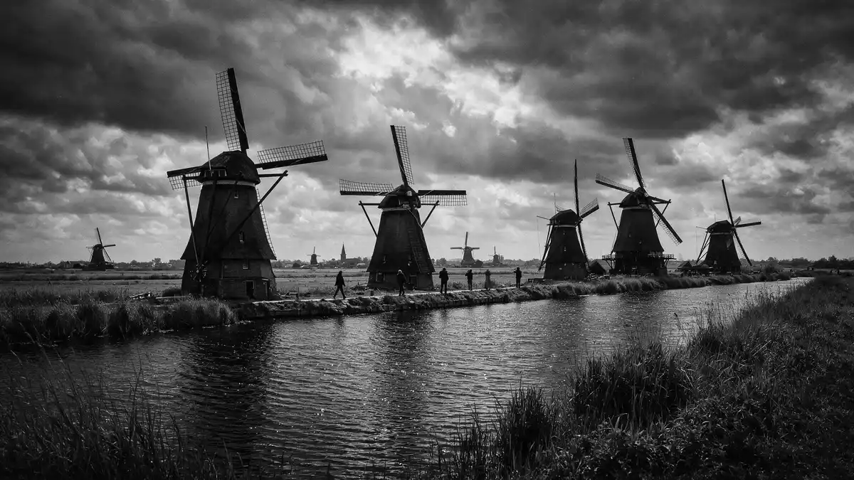
Kinderdijk in the Netherlands is a flat, open landscape where rows of historic windmills stand beside dykes, canals and reservoirs in a carefully engineered pattern. This network of hydraulic works, recognised as the Mill Network at Kinderdijk-Elshout, has been inscribed as a UNESCO World Heritage Site since 1997 and shows how Dutch communities shaped land and water into a single working system.
A landscape built around water management
The windmills of Kinderdijk stand in the Alblasserwaard polder in South Holland, a low-lying area where much of the land lies below sea level and has long been vulnerable to flooding.Kinderdijk windmills The landscape here is defined by straight drainage ditches, broad reservoirs and long dykes that hold back river water and guide excess into controlled channels.complex system of hydraulic works Walking through Kinderdijk, the relationship between water and land is visible everywhere: fields sit slightly raised above mirror-bright canals, and embankments frame the horizon.
The Mill Network at Kinderdijk-Elshout brings together nineteen monumental windmills, pumping stations, dykes, sluices and storage basins in a single polder system.Mill Network at Kinderdijk-Elshout The site covers more than 300 ha (around 800 acres), with each element playing a defined role in lifting water from the polders into higher reservoirs so that it can drain towards the rivers.322 ha area The result is not a single monument but an entire cultural landscape shaped around water management.
Windmills, pumps and centuries of engineering
Kinderdijk’s story stretches back many centuries, as communities in the Alblasserwaard began building dykes and hydraulic works in the Middle Ages to make settlement and agriculture possible in the marshy ground.construction of hydraulic works began in the Middle Ages The oldest windmill site in Kinderdijk is associated with the Blokweerse mill, where a windmill stood by 1542 and the current structure dates from 1630.Blokweerse windmill from 1630 These early drainage mills helped move water out of low-lying polder land and towards the river systems that surround the area.
The best-known phase of construction at Kinderdijk took place between 1738 and 1740, when sixteen windmills connected to storage basins were built and added to the older mills.sixteen windmills between 1738 and 1740 Together with the existing structures, these mills created the present total of nineteen, arranged so that water could be lifted step by step from lower polders into higher reservoirs before flowing out through sluice gates.windmills lifting water in series Some of the mills are built as stone ground-sailers, others as wooden smock mills, reflecting different engineering approaches within the same drainage network.
Living World Heritage in a Dutch village
Kinderdijk today is both a working landscape and a village, with farmhouses, towpaths and local roads woven around the historic infrastructure.Kinderdijk village The Mill Network at Kinderdijk-Elshout was inscribed on the UNESCO World Heritage List in 1997 for its outstanding demonstration of Dutch expertise in handling water and protecting settled land from inundation.inscribed in 1997 The site shows all the typical features of this technology: dykes, reservoirs, pumping stations, administrative buildings and historic windmills preserved in working condition.dykes, reservoirs and pumping stations
The windmills in the Nederwaard and Overwaard polders, along with later pumping stations, form a chain that still demonstrates how water can be controlled in a flat, river-fed landscape.Nederwaard and Overwaard polders While modern electric and diesel pumps have taken over much of the day-to-day work of drainage, the historic mills remain maintained and have been used as backup when mechanical systems were interrupted.historic mills as backup For visitors, Kinderdijk offers a chance to see how engineering, landscape and settlement have been intertwined across several centuries in one Dutch polder.
Visiting Kinderdijk: what travellers from Western Europe should know
- Kinderdijk lies in the province of South Holland, south-east of Rotterdam, and can be reached by regional roads and public transport links serving the village and nearby towns.
- The terrain around the windmills is flat but exposed, with long sections of paths on dykes and beside canals that involve walking on open embankments without shade.
- Kinderdijk is in the Netherlands, where the official language is Dutch and the currency is the euro.
Searching for Kinderdijk on social platforms
These links open searches for Kinderdijk on each platform.
Frequently asked questions about Kinderdijk
Where is Kinderdijk and what kind of place is it?
Kinderdijk is a village and polder landscape in South Holland, the Netherlands, known for its network of historic windmills, dykes and water management works.
What can travellers expect when visiting Kinderdijk?
Travellers encounter a wide, open landscape with canals, reservoirs and rows of windmills, reached by paths on dykes that give broad views over the surrounding polder.
What makes Kinderdijk distinctive among Dutch landscapes?
Kinderdijk is distinctive because its nineteen windmills, pumping stations and hydraulic structures form a single, well-preserved system recognised as a UNESCO World Heritage Site for water management.


