
Kerala Backwaters around Alappuzha: water, villages and paddies
Published on 09/12/2026 at 22:16 | Editorial responsibility: Rafael Müller, Editor-in-Chief AD HOC NEWS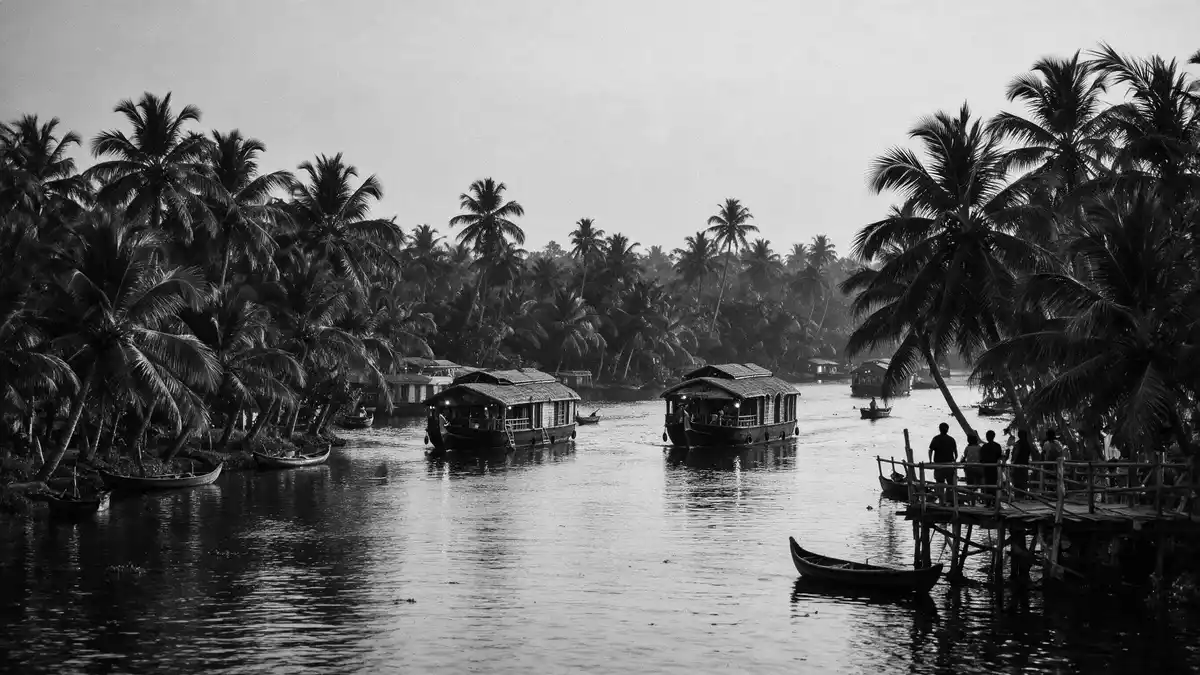
South of Kochi, around the coastal town of Alappuzha in Kerala, the Kerala Backwaters spread across a low-lying landscape of water channels, lakes and paddy fields. This is a brackish world of canals and lagoons running roughly parallel to the Arabian Sea along the Malabar Coast, shaped by the meeting of river water and the tide.
Waterways parallel to the Arabian Sea
The Kerala Backwaters form a network of brackish lagoons and canals that run inland alongside the Arabian Sea, following the line of Kerala’s Malabar Coast between the coast and higher ground further east.network of brackish lagoons The system includes rivers flowing down from the Western Ghats, small creeks and man-made canals that link natural lakes into continuous waterways.
Across the state, several river deltas feed into these waters, among them the Pamba and Meenachil rivers whose lower reaches form part of the canals and lakes near Alappuzha.important rivers from north to south The result is a landscape where stretches of open water such as Vembanad Lake sit alongside narrow channels bordered by coconut palms, embankments and clusters of houses.
Alappuzha and Kuttanad: a low-lying backwater region
Alappuzha stands in the Kuttanadu region, a low-lying area known for extensive paddy fields and for land lying close to, and in places below, sea level.Kuttanadu is a region spanning the Alappuzha and Kottayam districts Between the town and the Arabian Sea, canals and lakes create long water corridors lined with villages and fields separated by earthen bunds.
These fields and waterways have been part of local agriculture for generations, with the backwaters used to move produce and people between settlements and market towns.have been a thriving conduit for local trade and transport for centuries The waterways link Alappuzha to other backwater hubs such as Kumarakom and Kollam, forming continuous routes that pass churches, temples and small jetties on their way towards larger lakes including Vembanad.Vembanad, Ashtamudi, Sasthamkotta Lakes
Houseboats, ferries and life along the canals
On the water itself, movement ranges from small canoes to large converted barges known locally as houseboats. These craft draw on older cargo vessels that once carried rice and other goods along the canals and lakes, and now travel routes across Vembanad Lake and the narrower channels near Alappuzha.major component of back-water tourism is the houseboat cruising Traditional ferries and small passenger boats continue to run between banks and across waterways, connecting villages and paddy fields.
Along many channels the banks carry a ribbon of houses, small shrines and landing places, with narrow paths following the water and simple bridges crossing narrower canals.backwaters are a mesmerising network of lakes, canals, and lagoons In places, long embankments separate paddies from the backwaters, with sluices managing the flow between fields and canals. Travelling by boat gives a close view of this everyday waterside landscape, from fishing activity to agriculture in plots divided by straight bunds.
Visiting Kerala Backwaters: what travellers from Western Europe should know
- The Kerala Backwaters around Alappuzha lie in the southern Indian state of Kerala, with Alappuzha reachable by rail and road from Kochi and other regional centres.
- Boat journeys often start from jetties on canals or from the shores of Vembanad Lake, and access may involve walking along narrow paths or simple piers with steps down to the water.
- The terrain in the Kuttanadu region is low-lying and intersected by waterways, so routes between villages may include bridges over canals and stretches along embankments above paddy fields.
- The official language of the region is Malayalam and the currency is the Indian rupee.
- Entry requirements depend on your nationality; UK travellers can check the FCDO travel advice at gov.uk/foreign-travel-advice, Irish travellers the Department of Foreign Affairs at ireland.ie.
Searching for Kerala Backwaters on social platforms
These links open searches for Kerala Backwaters on each platform.
Frequently asked questions about Kerala Backwaters
Where are the Kerala Backwaters near Alappuzha located?
The Kerala Backwaters near Alappuzha lie in the Kuttanadu region of Kerala, India, between the Arabian Sea coast and inland higher ground.
What can a visitor expect when travelling through the Kerala Backwaters?
A visit brings slow journeys along canals and lakes, views of paddy fields and villages, and travel on boats ranging from small canoes to larger houseboats.
What makes the Kerala Backwaters around Alappuzha distinctive?
This area combines extensive low-lying rice fields, a long-established network of interconnected waterways and settlements which are closely tied to life on the water.


