
Kapadokya’s carved landscape around Göreme
Published on 09/01/2026 at 21:13 | Editorial responsibility: Rafael Müller, Editor-in-Chief AD HOC NEWS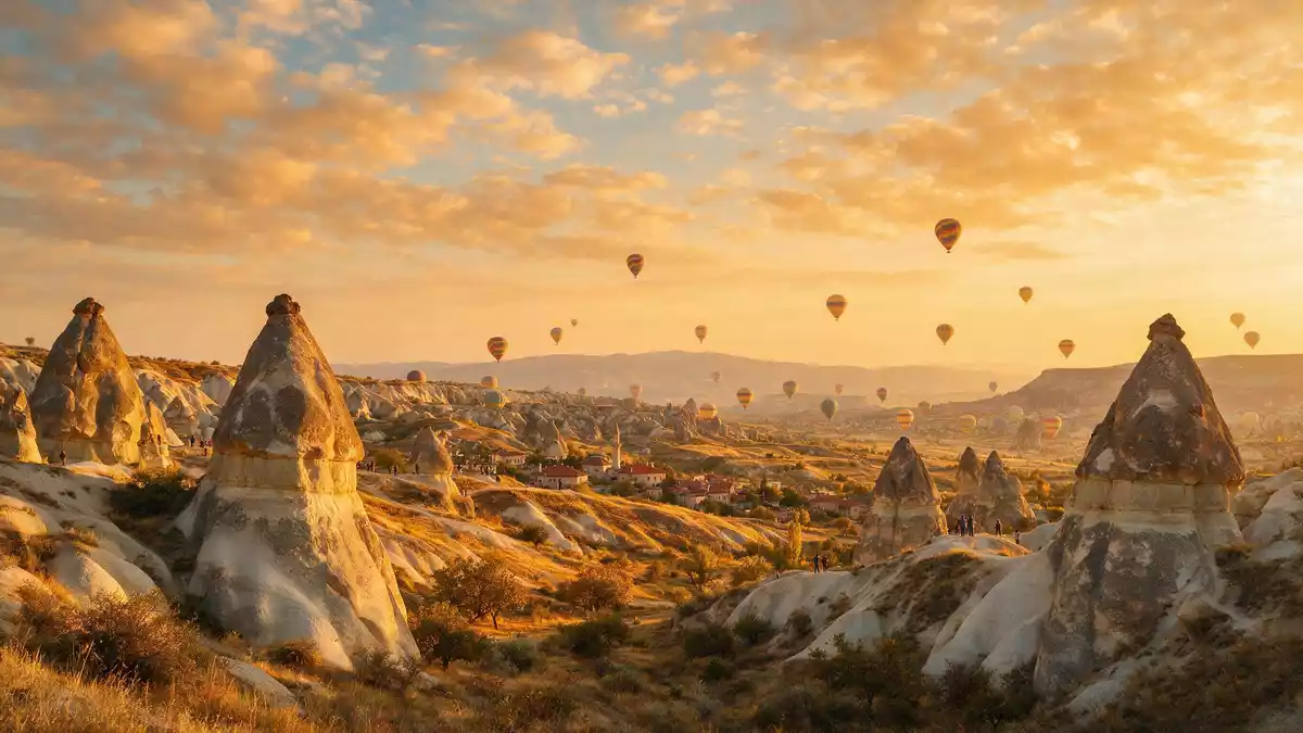
Kapadokya, the historical region known in English as Cappadocia, unfolds around Göreme in central Turkey as a landscape where soft volcanic rock has been sculpted into pinnacles and valleys and hollowed into homes and churches.Kapadocia in Central Anatolia is a long-settled region, but Göreme and its surroundings gained particular recognition in the twentieth century when the national park and rock sites were inscribed as a UNESCO World Heritage Site in 1985.Göreme National Park and the Rock Sites of Cappadocia
Kapadokya as a volcanic plateau of tuff and cones
The core of Kapadokya around Göreme lies on a plateau in Central Anatolia shaped by eruptions from Mount Erciyes and Mount Hasan, two extinct volcanoes rising to over 3,000 m (9,843 ft).volcanic landscape sculpted by erosion Over many millennia, ash from those eruptions compacted into a soft rock called tuff, while harder lava layers formed caps above it.tuff and capstone geology Wind, rain and seasonal temperature changes gradually carved this tuff into ridges, valleys and the tall pillars topped with harder stones that are known locally as fairy chimneys.
Around Göreme these rock formations stand in clusters, with slopes banded in colours where different layers of volcanic material are exposed.Göreme within the national park The softness of the tuff has allowed residents and monastic communities to carve into it with comparative ease, creating a landscape in which cliffs and freestanding cones are punctured by openings that lead into interior spaces rather than standing as solid rock faces. The result is a terrain where geology and building are closely intertwined and where the distinction between natural form and human-made structure can be subtle.
Rock-cut churches, cave dwellings and underground refuges
Kapadokya’s cultural significance around Göreme rests on the long tradition of carving religious and domestic spaces directly into the rock, especially from the fourth century onwards.rock-hewn sanctuaries and troglodyte villages Within a relatively compact area east of the town lies the Göreme Open Air Museum, where numerous Byzantine churches and chapels are hollowed out of the tuff, some with frescoes that retain vivid colour in dim interiors.Göreme Open Air Museum churches These sanctuaries form part of a wider network of monastic spaces, refectories and dwellings cut into the same slopes, creating stacked and adjoining rooms that follow the shape of the cliffs.
Further across Kapadokya are the underground cities of Derinkuyu and Kaymakl?, accessed by tunnels descending through the tuff to deep levels where chambers, passageways and ventilation shafts extend over large areas.Derinkuyu and Kaymakl? underground cities These subterranean complexes form part of the World Heritage listing together with the national park, underlining how human use of the rock ranges from surface dwellings to deep refuges. In the valleys nearer Göreme, smaller cave houses and pigeon cotes are also carved into slopes and cones, extending the carved landscape beyond explicitly religious architecture.
Göreme’s setting within the Kapadokya region
Göreme itself is a town (*belde*) in the Nev?ehir District of Nev?ehir Province, forming one of the main settlements in the touristic part of Kapadokya.Göreme in Nev?ehir Province The town sits within the boundaries of Göreme National Park, and valleys with names such as Red, Rose and Pigeon extend around it, each characterised by different shades and profiles of eroded tuff.Göreme and its surrounding valleys Nearby, other Kapadokya settlements including Uçhisar, Ürgüp and Avanos occupy terraces and slopes on the same plateau, and together they form the inhabited frame around the national park.
The UNESCO inscription covers both natural and cultural criteria, recognising that the erosional landscape and the rock-cut architecture form an interdependent whole across this part of Kapadokya.mixed natural and cultural World Heritage site Within the wider historical region of Kapadokya, Göreme and the national park occupy a central position between Nev?ehir, Ürgüp and Avanos, bounded at greater distance by the extinct volcanoes whose eruptions created the plateau in the first place.region between Nev?ehir, Ürgüp and Avanos The combination of small-scale town life, visible monastic history in the cliffs and wide views across sculpted valleys gives this part of Kapadokya a distinct character within Central Anatolia.
Visiting Kapadokya: what travellers from Western Europe should know
- Kapadokya around Göreme lies in central Turkey, in Nev?ehir Province, east of Ankara; Göreme is reached overland via Nev?ehir and Kayseri, the main transport hubs for the region.
- The national park landscape around Göreme consists of valleys, ridges and freestanding tuff cones, with many paths and stairways on uneven rock and earth surfaces that require steady footing.
- The nearest airports to Göreme are Nev?ehir Kapadokya Airport and Kayseri Airport, which stand to the west and east of the national park and connect the region with other parts of Turkey.
- The official language is Turkish and the currency is the Turkish lira.
- Entry requirements depend on your nationality; UK travellers can check the FCDO travel advice at gov.uk/foreign-travel-advice, Irish travellers the Department of Foreign Affairs at ireland.ie.
Searching for Kapadokya on social platforms
These links open searches for Kapadokya on each platform.Frequently asked questions about Kapadokya
Where is Kapadokya in relation to Göreme?
Kapadokya is a historical region in Central Anatolia, and Göreme is one of its principal towns within Nev?ehir Province, set inside Göreme National Park.
What should visitors expect when exploring Göreme and its surroundings?
Visitors encounter valleys and pinnacles of soft tuff, many carved into churches, dwellings and small cave spaces, with paths and stairways laid out across the eroded terrain.
What makes Kapadokya around Göreme distinctive among Turkish landscapes?
The combination of volcanic geology, fairy chimney formations, extensive rock-cut religious architecture and deep underground cities gives this part of Kapadokya a character that is closely tied to its sculpted rock.


