
Isla del Sol, Lake Titicaca’s sacred island ridge
Published on 09/01/2026 at 22:36 | Editorial responsibility: Rafael Müller, Editor-in-Chief AD HOC NEWS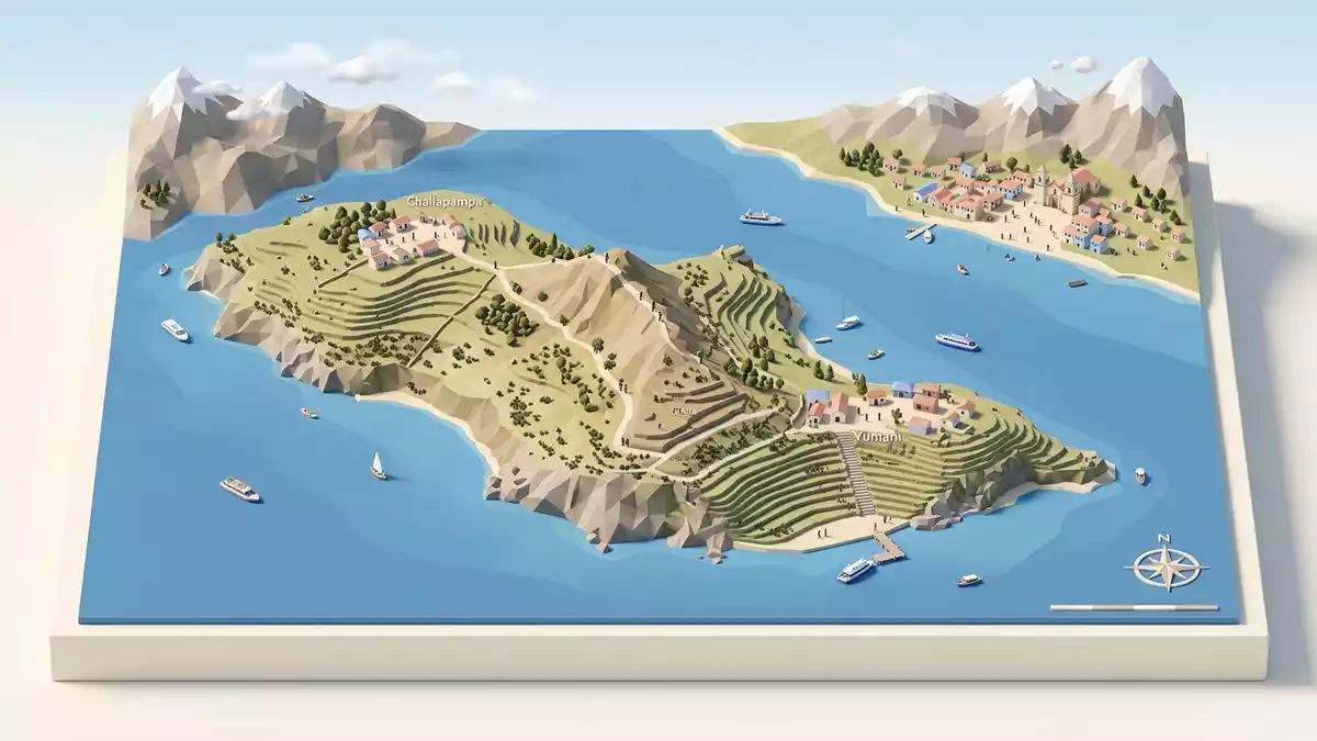
Isla del Sol is a high Andean island rising from the Bolivian side of Lake Titicaca, opposite the small town of Copacabana, with a long spine of paths and terraces running above the water. The island forms part of the La Paz Department and sits within the municipality of Copacabana in the province of Manco Kapac, linking Lake Titicaca’s blue expanse with a network of villages and archaeological remains.
An island ridge between lake and sky
Isla del Sol lies in the southern portion of Lake Titicaca, a vast body of water on the Bolivian–Peruvian Altiplano plateau.southern part of Lake Titicaca The lake surface stands at roughly 3,810 m (12,500 ft) above sea level, which means that even the shore approaches the elevation of many Alpine summits in Europe.lake level 3,810 m The island itself rises higher still into low, rounded ridges, with the highest points reaching over 4,000 m (13,123 ft) and carrying long stone paths along their crest.rocky 9.6 km² island
In plan, Isla del Sol stretches roughly north–south for around 9 to 10 km, with a width that reaches about 4.6 km at its broadest point and a total area in the region of 14 km².length and surface This makes it the largest island in Lake Titicaca and gives it a substantial presence on the water, visible from the bays and headlands around Copacabana.largest island in the lake The slopes are cut into agricultural terraces and dotted with small fields, creating horizontal bands of cultivation that follow the contour lines above the shoreline.
Sacred landscapes and Inca archaeology
For Aymara-speaking communities and for the Inca civilisation, Isla del Sol held a central place in myth and ritual. In pre-Columbian belief, the lake and the island were linked with the creation of the sun and with the origins of the first Incas, Manco Cápac and Mama Ocllo.Inca legend of Viracocha Archaeological work on the island has identified human presence dating back to at least the third millennium BC, showing that settlement predates the Inca period by centuries.inhabited since the third millennium B.C.
During the fifteenth century, under Inca rule, the island became a major ceremonial centre, with structures such as the Temple of the Sun and a dense pattern of shrines and ritual platforms.ruins dating to the 15th century More than 80 archaeological sites have been recorded, ranging from temple complexes and carved rock features to stairways, fountains and walls associated with Inca and earlier cultures.over 80 known archaeological sites These sites sit within walking distance of present-day villages, so paths between houses frequently pass foundations, carved stones and ritual features dating back several centuries.
Villages, terraces and car-free paths
Isla del Sol is car-free, and movement between its communities follows stone paths and stairways that rise from small harbours on the lake.small, car-free island Three main villages retain Aymara as an everyday language: Yumani in the south, Cha’lla near the centre and Challapampa to the north.three communities of indigenous origin Together, these communities are home to several hundred residents, whose livelihoods combine farming, fishing, weaving, boat work and small-scale tourism.about 800 Aymara families
The island’s terraces and ridge paths form a continuous walking route between north and south, generally described as a ridge trail of around 10 to 12 km linking Challapampa and Yumani.north–south ridge route This route passes fields edged by stone walls, small bays with boats drawn up on the shore, and elevated viewpoints from which the snow-capped Cordillera Real can sometimes be seen across the water. On the southern slopes, long stairways climb from the lakeside into the terraces, connecting the harbour with lodging, small eateries and informal gathering spaces in the upper part of Yumani.Yumani, Challa and Challapampa
Visiting Isla del Sol: what travellers from Western Europe should know
- Isla del Sol lies off the shore of Lake Titicaca to the north-west of Copacabana, which is reached overland from La Paz and serves as the embarkation point for boats crossing to the island.
- The island is entirely pedestrian, with stone paths, steps and terraced slopes connecting its villages; reaching the main ridge involves climbing significant stairways from the small harbours.
- The terrain combines lake-level paths at roughly 3,810 m (12,500 ft) with higher stretches over 4,000 m (13,123 ft), so walking routes include sustained gradients at high altitude.
- Nearby features include the bays and small headlands of Copacabana’s peninsula on the mainland and distant views towards the Cordillera Real mountains on clear days.
- The official language is Spanish and the currency is the Bolivian boliviano; entry requirements depend on your nationality, UK travellers can check the FCDO travel advice at gov.uk/foreign-travel-advice, Irish travellers the Department of Foreign Affairs at ireland.ie.
Searching for Isla del Sol on social platforms
These links open searches for Isla del Sol on each platform.
Frequently asked questions about Isla del Sol
Where is Isla del Sol located?
Isla del Sol lies in the southern part of Lake Titicaca, within Bolivia’s La Paz Department, off the shore from the lakeside town of Copacabana.
What can visitors expect on a visit to Isla del Sol?
Visitors encounter stone paths, agricultural terraces, small Aymara-speaking villages and a series of pre-Columbian archaeological sites set above the lake.
What makes Isla del Sol distinctive among Andean destinations?
The combination of high-altitude island geography, strong living community traditions and Inca-era ceremonial sites gives Isla del Sol a rare mix of landscape and archaeology.


