
Isla de Ometepe, the twin-volcano island on Lake Nicaragua
Published on 09/12/2026 at 18:06 | Editorial responsibility: Rafael Müller, Editor-in-Chief AD HOC NEWS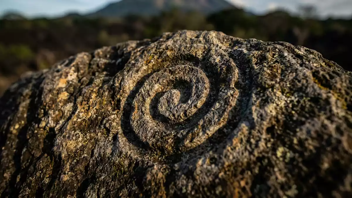
Isla de Ometepe is a freshwater island in Lake Nicaragua, its outline shaped by two volcanic cones rising from the water and joined by a narrow strip of land. The island lies in the Rivas Department of south?western Nicaragua and has been recognised as a biosphere reserve in the early twenty?first century, reflecting its mix of forest, farmland and lake shore habitats.UNESCO Biosphere Reserve
A figure?of?eight island of two volcanoes
Isla de Ometepe is formed by Volcán Concepción and Volcán Maderas, a pair of volcanoes joined by an isthmus that gives the island a figure?of?eight plan. Concepción is the higher of the two, reaching about 1,610 m (5,282 ft), while Maderas rises to around 1,394 m (4,573 ft), and together they create one of the most distinctive silhouettes on Lake Nicaragua.Concepción and Maderas The island’s name itself comes from the Nahuatl language, combining “ome” and “tepetl” to mean “two mountains”, a straightforward description of its twin peaks.name from Nahuatl
Measured from end to end, Isla de Ometepe is about 31 km (19 mi) long, and between roughly 5 and 10 km (3.1 to 6.2 mi) wide depending on the section of shoreline.length and width Its total area is around 276 km² (107 sq mi), making it the largest island in Lake Nicaragua and one of the larger islands found within any freshwater lake worldwide.largest lake island in Nicaragua The profile of Concepción dominates the northern part of the island, while Maderas occupies the southern half, and the low connecting land between them carries roads, farmland and small settlements.
Lake, fertile soils and rural communities
Isla de Ometepe sits in the western part of Lake Nicaragua, a large inland lake that occupies much of central Nicaragua, with the island lying a few kilometres offshore from the lakeside town of Rivas.location in Lake Nicaragua The shore around Ometepe alternates between sandy beaches, small harbours and stretches of vegetation reaching down to the water, so that views from the island take in both the open lake and distant mainland ridges. The lake itself is a defining presence, surrounding the volcanic land with an expanse of freshwater that contrasts with the island’s steep slopes.
The soils on Isla de Ometepe are enriched by volcanic material, and much of the lower ground is cultivated. Fields of crops, grazing land for livestock and patches of small?scale coffee and tobacco production share space with forest fragments and orchards.fertile and forested land Rural communities such as Moyogalpa and Altagracia are the main towns, acting as hubs for ferries, markets and accommodation, while smaller villages and roadside clusters extend along the loop of roads that ring each volcanic flank.Moyogalpa and Altagracia Life on the island reflects this combination of agriculture and nature, with houses, fields and forest patches sharing the slopes above the lake.
Trails, petroglyphs and protected landscapes
Visitors encounter Isla de Ometepe as a landscape of gradients, footpaths and forest tracks climbing from lake level into the flanks of Concepción and Maderas. Trails lead through tropical vegetation on the lower slopes and continue into higher, cloudier levels on the volcanoes, where the air cools and views open out across the lake and surrounding countryside.volcanic island with crater hikes Away from the main paths, the terrain can be steep and muddy, with exposed roots and sections of loose volcanic material underfoot, especially on the upper parts of Concepción.
The island is also known for pre?Columbian petroglyphs carved into stones, found in various locations on Maderas and in the surrounding countryside, where they sit amid farmland and forest clearings.pre-Columbian petroglyphs These engravings add archaeological interest to the natural setting, hinting at long human occupation on the island that predates Spanish contact by many centuries. The biosphere reserve status highlights both the ecological value of Ometepe’s forests and wetlands and the presence of communities whose livelihoods are closely tied to the land and the lake.
Visiting Isla de Ometepe: what travellers from Western Europe should know
- Isla de Ometepe lies in Lake Nicaragua in south?western Nicaragua, off the shore near the town of Rivas; ferries connect mainland ports such as San Jorge with island harbours including Moyogalpa.
- Roads encircle much of each volcanic flank, but away from these the terrain is demanding, with steep footpaths, sections of loose volcanic ground and long ascents for any traveller heading towards the higher slopes.
- The official language is Spanish and the currency is the Nicaraguan córdoba.
- Entry requirements depend on your nationality; UK travellers can check the FCDO travel advice at gov.uk/foreign-travel-advice, Irish travellers the Department of Foreign Affairs at ireland.ie.
Searching for Isla de Ometepe on social platforms
These links open searches for Isla de Ometepe on each platform.
Frequently asked questions about Isla de Ometepe
Where is Isla de Ometepe?
Isla de Ometepe is an island in Lake Nicaragua in south?western Nicaragua, part of the Rivas Department and lying a short distance offshore from the town of Rivas.
What can travellers expect on a visit?
A visit to Isla de Ometepe brings boat crossings on the lake, views of the twin volcanic cones, rural communities, cultivated land, forested slopes and trail networks on both volcanoes.
What makes Isla de Ometepe distinctive?
The island’s distinctive character comes from its twin volcanoes joined by an isthmus, its figure?of?eight outline on a large freshwater lake and its combination of fertile farmland, forest and archaeological remains.


