
Isla de Ometepe, the twin-volcano island in Lake Nicaragua
Published on 08/22/2026 at 08:50 | Editorial responsibility: Rafael Müller, Editor-in-Chief AD HOC NEWS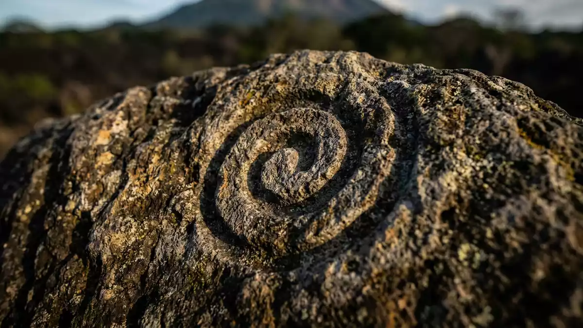
Isla de Ometepe is an island of twin volcanoes rising from Lake Nicaragua, where black volcanic slopes, rural farmland and lakeshore villages form a single, striking landscape. Set within the Rivas Department in south-western Nicaragua, the island centres on the silhouettes of Concepción and Maderas and the freshwater expanse that surrounds them.
Twin volcanic peaks shaped as a freshwater island
Isla de Ometepe lies in Lake Nicaragua, the largest freshwater lake in Central America, and is part of the Rivas Department in the south-west of the country.Lake Nicaragua, the largest freshwater lake The island is formed by two large stratovolcanoes, Concepción and Maderas, which are joined by a low isthmus into a single, elongated mass of land.two volcanoes rising out of Lake Nicaragua From the lake, the profile resembles a pair of uneven cones connected by a narrow waist, creating one of Nicaragua’s most distinctive inland horizons.
Concepción forms the north-western half of Isla de Ometepe and is an active stratovolcano whose cone rises to about 1,610 m (5,282 ft).Concepcion rises to 1,610 metres Maderas, to the south-east, is lower at about 1,394 m (4,573 ft) and has not erupted in historical times, its upper slopes cloaked in cloud forest and its summit holding a crater lake.Maderas holds a crater lake at its top A narrow strip of land, known locally as the Istian isthmus, links the two volcanoes, keeping the island’s overall area to around 276 square kilometres (107 sq mi) while giving it a recognisable dumbbell outline.combined area is about 107 square miles
A biosphere reserve of farms, forest and freshwater
In June 2010, Isla de Ometepe was recognised by UNESCO as a biosphere reserve under the Man and the Biosphere Programme, reflecting the mixture of volcanic slopes, freshwater shoreline and rural settlement.Ometepe Island Biosphere Reserve The designation covers the whole island and part of Lake Nicaragua around it, including sections of the San Juan River, and highlights both biodiversity and long-standing agricultural use.Reserva Isla de Ometepe
On the lower flanks of Concepción and Maderas, fields of plantain, banana and other crops reach almost to the lakeshore, interspersed with remnant patches of dry forest and small settlements. Higher up Maderas, the vegetation shifts into cloud forest, where epiphytes and dense canopy cover the upper slopes. Along parts of the shoreline, narrow black-sand and grey-sand beaches show the volcanic origin of the island, and in several areas the water stays shallow for some distance, giving broad views back to the twin peaks.
Villages, pre-Columbian traces and rural travel
Isla de Ometepe’s main settlements line the western and northern shores. Moyogalpa lies on the north-western coast below Concepción and serves as the principal gateway settlement, while Altagracia sits further east, closer to the isthmus and the lower slopes of Maderas.Alta Gracia and Moyogalpa are the island’s main towns Between and beyond these towns, smaller villages, farmsteads and lakeside hamlets follow the ring of the shore.
The human story on Isla de Ometepe runs much further back than the present-day villages. Archaeological finds on the island include petroglyphs and other pre-Columbian artefacts, many of them carved into boulders on the slopes of Maderas and in lowland fields.archaeological sites with petroglyphs Some of these stones stand near farm tracks or among cultivated land, where spirals, stylised figures and abstract motifs appear on weathered volcanic rock. Together with scattered remains of ancient settlements, they show how long the island’s freshwater setting and fertile soils have drawn people to live here.
Visiting Isla de Ometepe: what travellers from Western Europe should know
- Isla de Ometepe lies in Lake Nicaragua in the south-west of the country, reached by boat services from ports on the nearby mainland to towns such as Moyogalpa.
- The terrain combines lakeshore roads with stretches of unpaved track, and paths on the volcanoes rise steeply with long ascents on rough, sometimes muddy ground.
- On Maderas, higher paths pass through dense cloud forest with exposed roots and occasional slippery sections, while sections near the crater lake involve narrow, uneven ground.
- The official language is Spanish and the currency is the Nicaraguan córdoba.
- Entry requirements depend on your nationality; UK travellers can check the FCDO travel advice at gov.uk/foreign-travel-advice, Irish travellers the Department of Foreign Affairs at ireland.ie.
Searching for Isla de Ometepe on social platforms
These links open searches for Isla de Ometepe on each platform.
Frequently asked questions about Isla de Ometepe
Where is Isla de Ometepe?
Isla de Ometepe is an island in Lake Nicaragua in south-western Nicaragua, within the Rivas Department between the Pacific coast and the country’s central highlands.
What should visitors expect on a trip to the island?
Visitors encounter a rural landscape of two volcanoes, lakeshore villages, small farms, patches of forest and black-sand beaches, with basic roads and steep hiking terrain on the slopes.
What makes Isla de Ometepe distinctive?
The island is formed entirely by the twin volcanoes Concepción and Maderas in a freshwater lake and is recognised as a UNESCO biosphere reserve for its combined natural and cultural landscape.


