
Houmt Souk, market town of Djerba’s northern shore
Published on 09/07/2026 at 07:25 | Editorial responsibility: Rafael Müller, Editor-in-Chief AD HOC NEWS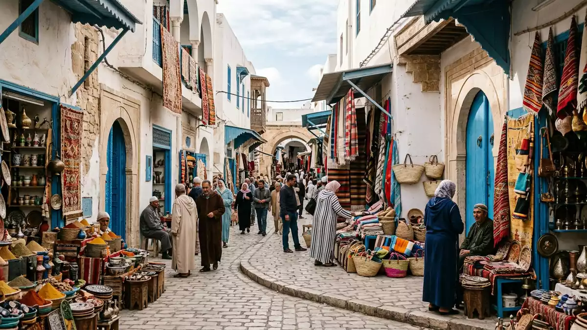
Houmt Souk on the island of Djerba in Tunisia is a market town on the northern coast where whitewashed houses, trading courtyards and a fishing harbour form a compact urban landscape that still revolves around commerce and the sea. As the main town of the Djerba-Houmt Souk municipality within the governorate of Médenine, it serves as the administrative centre for the island and its surrounding districts.main town of the island
A market neighbourhood shaped by trade
The name Houmt Souk comes from Arabic and can be translated as “market district” or “market neighbourhood”, a reminder that the town grew around its souk and trading activity rather than around a single monument.translated as market district The medina consists of narrow streets lined with small shops, stalls and covered passages where textiles, ceramics and everyday goods are displayed in dense rows. Many of the larger buildings in the centre were built as fondouks, caravanserai-like complexes with an internal courtyard used by travelling merchants as places to store goods and rest, some of which have been adapted into accommodation while keeping their arcaded layouts.fondouks turned into hotels
The town developed as a stopping point on trading routes that connected the Sahara, the Mediterranean and inland Tunisia, and its central area remains focused on exchange and small-scale commerce.a trading place between regions Within the medina, shops are grouped by craft or product, so whole streets are devoted to textiles or jewellery. The white and blue colour scheme on façades, shutters and doors gives the older quarters a unified appearance, with low-rise buildings creating an intimate scale that contrasts with the open space of the coastal edge.
Houmt Souk as Djerba’s administrative capital
Houmt Souk is the chief town of the Djerba-Houmt Souk municipality, which had tens of thousands of inhabitants in the early twenty-first century and covers more than 170 km² when outlying districts are included.municipality covers 176.54 km² The town itself had over 40,000 residents in mid-2000s census figures, and later counts for the wider commune give a population above 70,000, underlining its role as the main urban centre on Djerba.population figures for town and commune It stands within the governorate of Médenine, the administrative region that covers Djerba and parts of mainland south-eastern Tunisia.depends on the governorate of Médenine
Within Houmt Souk, municipal organisation divides the area into sectors or districts, separating the historic centre from more residential zones. The town lies on the northernmost part of Djerba, close to the island’s airport and roughly 20 km from Ajim, reached by ferry, and from El Kantara, approached by the causeway known as the Roman road.about twenty kilometres from Ajim and El Kantara Its coastal location places administrative offices, markets and transport connections within short reach of the sea, so that daily life is framed by the shoreline as much as by the streets.
Fortress, harbour and the sea-facing edge
Houmt Souk’s northern waterfront combines a small fishing harbour with fortifications that overlook the water. The town is known for a fort commonly referred to as Borj El Ghazi Mustapha or Bordj el-Kebir, an Ottoman-era coastal fortress that forms part of the ensemble of historic structures on Djerba.Borj El Ghazi Mustapha The fort stands close to the shoreline, with thick walls and defensive towers set above low ground near sea level. From its ramparts the view takes in the fishing port and the gentle curve of the island’s northern coast.
Beside the fort, the harbour area accommodates fishing boats that bring in catches sold at the town’s fish market, a daily institution located within walking distance of the medina. The urban edge between the fort and the market marks the transition from commercial streets to the open seafront, with a few beaches reachable on foot from the centre.fort, harbour and nearby beaches Other religious and civic buildings, including mosques and a nineteenth-century Catholic church, stand in the town, adding layers of architecture from different periods to the otherwise predominantly low and whitewashed fabric.nineteenth-century Catholic church
Visiting Houmt Souk: what travellers from Western Europe should know
- Houmt Souk lies on the northern part of Djerba in southern Tunisia, within the governorate of Médenine; the town is reached from the mainland via Ajim ferry or the El Kantara causeway road.
- The historic centre consists of narrow streets and trading courtyards, with some approaches involving uneven paving and short flights of steps between the medina and the harbour.
- The official language is Arabic and the currency is the Tunisian dinar.
- Entry requirements depend on your nationality; UK travellers can check the FCDO travel advice at gov.uk/foreign-travel-advice, Irish travellers the Department of Foreign Affairs at ireland.ie.
Searching for Houmt Souk on social platforms
These links open searches for Houmt Souk on each platform.
Frequently asked questions about Houmt Souk
Where is Houmt Souk located?
Houmt Souk is on the northern coast of Djerba, an island in southern Tunisia, and forms part of the governorate of Médenine.
What can visitors expect in Houmt Souk?
Visitors find a dense medina with souks, fondouks and small shops, a coastal fishing harbour and a historic fort on the sea-facing edge of the town.
What makes Houmt Souk distinctive on Djerba?
Houmt Souk combines the island’s main market streets, administrative functions and a waterfront fortress, concentrating much of Djerba’s everyday and historic life in one town.


