
Hakodateyama and the harbour skyline of Hakodate
Published on 09/18/2026 at 18:40 | Editorial responsibility: Rafael Müller, Editor-in-Chief AD HOC NEWS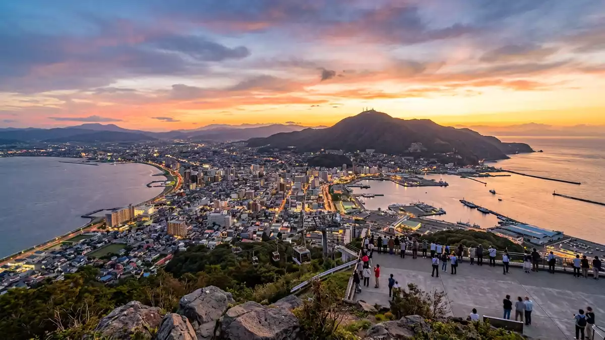
Hakodateyama, known in English as Mount Hakodate, is a low volcanic mountain rising above the port city of Hakodate in Japan’s northern island of Hokkaido. Its wooded slopes and compact summit sit at the southern end of the Hakodate peninsula, giving wide views over the harbour districts and the open water on both sides.
A harbour mountain shaped by land and sea
Hakodateyama is a modest mountain by elevation, reaching a height of around 334 m (1,096 ft) above sea level, yet it dominates the city’s southern skyline because much of Hakodate spreads out on the low-lying peninsula beneath it.334 m wooded mountain The slopes rise steeply from the harbour-front streets into a broad summit area, so the change from city grid to mountain terrain is abrupt and visible almost as a single sweep.
The mountain forms a natural backdrop to central Hakodate: warehouses, piers and ferry terminals line the waterfront, while traditional residential districts such as Motomachi climb partway up the hillside before giving way to forest. From the summit, the city appears sandwiched between two contrasting coasts, with the main harbour to one side and more open waters on the other.broad views over the city and harbour On clear days the view extends beyond the urban area to low hills and headlands further along the shoreline.
Reaching the summit: ropeway and mountain roads
Hakodateyama is accessible by several routes that climb from the city to the summit area. One of the most visible is the Hakodateyama Ropeway, an aerial lift that carries large gondolas from a lower station in the Motomachi district up to the observatory near the top of the mountain.Mt. Hakodate Ropeway aerial lift The line has been in operation since 1958 and functions as both a public transport link to the summit and a viewpoint in its own right, giving passengers an elevated perspective as it climbs above the rooftops.
The ropeway’s lower station stands close to Hakodate’s historic tram routes and the sloping streets of Motomachi, so it connects the hillside districts directly with the summit facilities.Hakodateyama Ropeway station in Motomachi In addition to the aerial lift, a toll-free mountain road leads up to the top during the warmer months, tracing a series of curves through the forest and joining parking areas near the observatory.road to the summit of Mount Hakodate Bus services also connect the railway station with the summit area when the road is open, tying Hakodateyama into the wider transport network of the city.
Summit observatories and the Hakodate skyline
The top of Hakodateyama is laid out as an accessible viewpoint, with observation platforms and terraces arranged to face the city and the enclosing waters. These platforms stand close to the ropeway’s upper station and give unobstructed panoramic views, with railings and open decks designed for visitors to look out across the peninsula.observation platforms at the summit The summit area also includes indoor spaces such as a café and souvenir outlets, so the viewpoint functions both as a lookout and as a small hilltop complex.
From these terraces the urban plan of Hakodate becomes legible: rectilinear streets align towards the harbour, rail lines and ferry quays mark the transport corridors, and the outline of the peninsula is visible as a narrow strip of land between two bodies of water.view over both sides of the peninsula At night the skyline changes character, with illuminated streets and harbour structures tracing lines of light along the shoreline and into the hills. The combination of low mountain, extended cityscape and enclosing sea gives Hakodateyama a distinct profile among Japanese harbour viewpoints.
Visiting Hakodateyama: what travellers from Western Europe should know
- Hakodateyama rises at the southern end of the Hakodate peninsula in Hokkaido, immediately above central Hakodate’s harbour and Motomachi districts. The mountain is reached from the city by the Hakodateyama Ropeway or by bus and mountain road.
- The summit area is laid out with terraces and buildings close together, so moving between the ropeway station, observation platforms and indoor facilities involves short walks on paved surfaces with some steps.
- Hakodateyama stands in northern Japan, where winters are cold and snowfall is common, so conditions on the mountain can differ from those at sea level even though the elevation is modest.
- The official language is Japanese and the currency is the yen.
- Entry requirements depend on your nationality; UK travellers can check the FCDO travel advice at gov.uk/foreign-travel-advice, Irish travellers the Department of Foreign Affairs at ireland.ie.
Searching for Hakodateyama on social platforms
These links open searches for Hakodateyama on each platform.Frequently asked questions about Hakodateyama
Where is Hakodateyama located?
Hakodateyama stands at the southern end of the Hakodate peninsula in Hokkaido, Japan, rising directly above the city’s harbour and central districts.
What can visitors expect at the summit?
The summit area has observation platforms, terraces and indoor facilities clustered near the ropeway’s upper station, all arranged to face the city and surrounding waters.
What makes Hakodateyama distinctive among Japanese viewpoints?
Hakodateyama combines a relatively low volcanic summit with wide views over a harbour city set on a narrow peninsula between two bodies of water, giving a characteristic skyline.


