
Gunung Rinjani on Lombok: Indonesia’s high volcanic ridge
Published on 08/27/2026 at 16:44 | Editorial responsibility: Rafael Müller, Editor-in-Chief AD HOC NEWS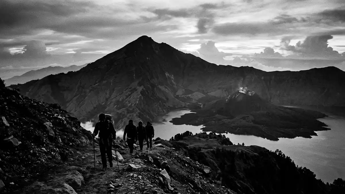
Gunung Rinjani is the dominant mountain mass on the Indonesian island of Lombok, an active stratovolcano whose ridges and crater lake shape the island’s northern skyline. Rising to 3,726 m (12,224 ft) above sea level, it is recognised as one of Indonesia’s highest volcanoes and forms the core of Gunung Rinjani National Park on Lombok. active stratovolcano on Lombok
The high volcanic ridge and its crater lake
Seen from the lowlands of Lombok, Gunung Rinjani appears as a broad volcanic massif, with steep flanks rising from coastal plains to a broken summit rim that encloses a large caldera. The summit reaches a confirmed elevation of 3,726 m (12,224 ft), placing the mountain well above the surrounding landscape and making it the highest point in the province of West Nusa Tenggara. 3,726 m summit elevation Inside the caldera lies Segara Anak, a crater lake set in the hollow left by earlier volcanic activity, with an active cone rising from its floor and emitting vapour at intervals. Segara Anak crater lake and cone
The broad form of the mountain reflects its identity as a stratovolcano: layers of lava and ash built up over hundreds of thousands of years to create a high cone with steep sides and a complex summit area. historic stratovolcano development The caldera’s inner cone, sometimes referred to as Barujari, sits offset within the lake and marks the focus of more recent eruptions recorded since the nineteenth century, while the outer rim offers long views across Lombok and towards neighbouring islands.
Gunung Rinjani National Park and protected landscapes
Gunung Rinjani and its surrounding highlands are protected within Taman Nasional Gunung Rinjani, a national park designated in 1990 that covers about 41,330 hectares (102,100 acres) of mountainous terrain on Lombok. 41,330-hectare national park The park boundary takes in the main summit, satellite peaks and extensive forests, with altitudes ranging from a few hundred metres above sea level to the top of the mountain. protected highland forests Within this area, land use shifts from cultivated valleys and traditional villages at the foot of the massif to grasslands, shrub zones and montane forest higher up.
The mountain and park form part of a broader conservation framework recognised under UNESCO’s Man and the Biosphere Programme, which identifies the Rinjani Lombok area as a biosphere reserve centred on the volcano. Rinjani Lombok biosphere reserve This status reflects the mix of ecosystems found on the slopes, from lower-elevation agroforestry and villages to upper ridges, crater walls and alpine-style zones around the summit. The protected status also encompasses cultural practices linked to the mountain, including ceremonies held by communities on Lombok in relation to the crater lake and summit area.
Geology, eruptions and cultural significance
Geologically, Gunung Rinjani stands within the volcanic arc that runs along southern Indonesia, where the Australian tectonic plate descends beneath the Sunda plate and magma rises to form chains of stratovolcanoes. volcanic arc context Historical records and scientific studies trace eruptions associated with the Rinjani massif back at least to the nineteenth century, including activity centred on the inner cone within the caldera. documented eruptions since 1847 The broader volcanic complex is linked in research to the much larger Samalas eruption in the thirteenth century, which reshaped the summit region and contributed to the current caldera form.
Beyond its physical presence and scientific interest, Gunung Rinjani holds a recognised place in the cultural life of Lombok. The mountain is described in travel and cultural accounts as sacred for Hindus and Sasak people, who visit the summit and crater lake on pilgrimages during specific rituals. Hindu and Sasak ritual visits Offerings are made at the lake and on the mountain, connecting contemporary religious practice with the landscape of the volcano and its long geological history. For visitors, the combination of high ridges, volcanic features and living traditions makes Gunung Rinjani a notable mountain environment within Indonesia.
Visiting Gunung Rinjani: what travellers from Western Europe should know
- Gunung Rinjani rises in the northern part of Lombok, Indonesia, within Gunung Rinjani National Park, reached from lowland towns on the island by road.
- The mountain involves sustained ascents over steep volcanic terrain, with long trails, loose rock underfoot in places and significant altitude differences between valley approaches and the summit rim.
- In addition to the high ridges, the park includes Segara Anak crater lake and forested slopes, so weather and visibility can vary markedly between lower valleys, lake level and the upper rim.
- The official language on Lombok is Indonesian and the national currency is the Indonesian rupiah.
- Entry requirements depend on your nationality; UK travellers can check the FCDO travel advice at gov.uk/foreign-travel-advice, Irish travellers the Department of Foreign Affairs at ireland.ie.
Searching for Gunung Rinjani on social platforms
These links open searches for Gunung Rinjani on each platform.Frequently asked questions about Gunung Rinjani
Where is Gunung Rinjani located?
Gunung Rinjani stands on Lombok in Indonesia, in the northern part of the island within Gunung Rinjani National Park, in West Nusa Tenggara province.
What should visitors expect when approaching Gunung Rinjani?
Visitors encounter a large volcanic massif with steep trails, changing vegetation zones and, at higher levels, a wide caldera containing the Segara Anak crater lake and an inner cone.
What makes Gunung Rinjani distinctive among Indonesian mountains?
Gunung Rinjani combines a high summit ridge, an extensive caldera with a crater lake and active cone, national park protection and recognised cultural and biosphere reserve significance on Lombok.


