
Gunung Rinjani and its high volcanic amphitheatre
Published on 08/22/2026 at 13:39 | Editorial responsibility: Rafael Müller, Editor-in-Chief AD HOC NEWS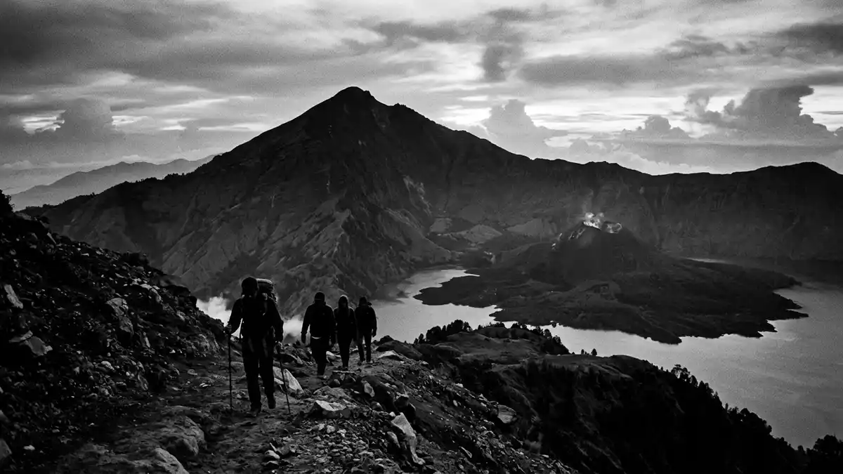
Gunung Rinjani on Lombok in Indonesia rises to 3,726 m (12,224 ft), forming a high volcanic massif that dominates the northern half of the island’s skyline. The mountain’s broad summit area encloses a caldera with a crater lake and a younger volcanic cone, creating a layered landscape of rock, water and ash that frames almost every view of this part of Lombok.
A high volcano above Lombok’s north
Gunung Rinjani is an active stratovolcano in the province of West Nusa Tenggara, rising in the northern part of Lombok and forming the highest point of the island.active stratovolcano in Lombok The mountain stands within Gunung Rinjani National Park, a protected area that covers a significant part of the massif and its surrounding forests.Gunung Rinjani National Park Viewed from the lowlands, its slopes rise from coastal plains into ridges and valleys that converge towards a broken summit rim.
With an elevation of 3,726 m (12,224 ft), Gunung Rinjani is recorded as the second-highest volcano in Indonesia after Kerinci in Sumatra.second-highest volcano in Indonesia The summit area forms part of a wide caldera that opens towards the east, its walls stepping down in cliffs and scree slopes to the interior. From ridges such as those above the villages of Senaru and Sembalun, the skyline shows the crescent shape of the caldera enclosing a high-altitude lake and newer volcanic vents.
Segara Anak, the crater lake within the caldera
Inside the caldera of Gunung Rinjani lies a crater lake known as Segara Anak, whose surface is a little over 2,000 m (6,562 ft) above sea level.surface of Segara Anak The lake spreads across an area measured at about 45 square kilometres (17 square miles), with a shape that follows the curve of the enclosing walls and a maximum depth reaching around 230 m (755 ft). Its blue water has given rise to the name Segara Anak, “child of the sea”, and on clear days the surface reflects the surrounding cliffs and the younger cone that rises from its shoreline.
The Segara Anak basin forms part of a wider geological story that includes the eruption of Mount Samalas in 1257, which created much of the present caldera on Lombok.volcanic lake formed in the caldera The lake occupies the western part of this amphitheatre-like depression, with steep slopes rising above its shores and areas of flatter ground used as camping sites near the water’s edge.Segara Anak crater lake description From the crater rim, paths descend to the lakeside, where the contrast between the high walls, the blue water and the cinder-covered slopes of newer vents is especially sharp.
UNESCO Global Geopark and sacred landscape
Gunung Rinjani and its surroundings form part of the Rinjani UNESCO Global Geopark, a designation recognising the area’s volcanic landforms, crater lake and associated geological heritage.Rinjani UNESCO Global Geopark The geopark encompasses the main summit, the Segara Anak caldera and the younger cone of Barujari, as well as lava flows and volcanic deposits that extend down the slopes towards inhabited valleys. Within this landscape, visitors encounter not only the steep topography of a high volcano but also forests, grasslands and agricultural land on the lower flanks.
The mountain holds religious significance for communities on Lombok, particularly Balinese Hindus and Sasak Muslims, who undertake pilgrimages to Segara Anak and to points on the crater rim.sacred to Hindus and Sasaks Offerings and rituals at the lake and around the hot springs mark the mountain as both a place of worship and a striking volcanic feature. This combination of geological scale and cultural practice gives Gunung Rinjani a dual identity as a natural structure and a sacred site, visible in shrines, ceremonial platforms and periodic gatherings around the caldera.
Visiting Gunung Rinjani: what travellers from Western Europe should know
- Gunung Rinjani rises in northern Lombok in Indonesia, within Gunung Rinjani National Park, and is reached by road from towns such as Mataram, Senaru and Sembalun.
- The terrain on the mountain includes steep paths on volcanic ash and rock, narrow ridges near the crater rim and descents into the caldera, requiring sure footing over uneven ground.
- At higher elevations the air becomes thin and temperatures can drop well below those in coastal Lombok, so layered clothing and protection against wind and rain are important on extended routes.
- The official language is Indonesian and the currency is the Indonesian rupiah. Entry requirements depend on your nationality; UK travellers can check the FCDO travel advice at gov.uk/foreign-travel-advice, Irish travellers the Department of Foreign Affairs at ireland.ie.
- Conditions on the mountain change with the seasons; the local cable-car operators and alpine clubs provide information.
Searching for Gunung Rinjani on social platforms
These links open searches for Gunung Rinjani on each platform.
Frequently asked questions about Gunung Rinjani
Where is Gunung Rinjani?
Gunung Rinjani stands in the northern part of Lombok in Indonesia, within Gunung Rinjani National Park in the province of West Nusa Tenggara.
What can visitors expect on a visit?
Visitors encounter a high volcanic massif with steep trails, a wide summit caldera, the crater lake Segara Anak and views across Lombok’s ridges towards the surrounding seas.
What makes Gunung Rinjani distinctive?
Gunung Rinjani combines a 3,726 m (12,224 ft) summit, a large caldera with the high crater lake Segara Anak and the status of a Rinjani UNESCO Global Geopark landscape.


